Missouri Climate Summary for 2010
In like a shivering lamb, out like a roaring lion
Pat Guinan
State Climatologist
Commercial Agriculture/University of Missouri Extension
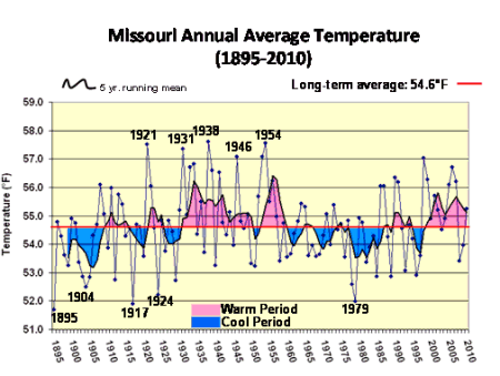
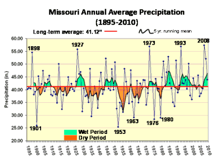
Weather wise, 2010 was another eventful year for the Show-Me state. It started off with abundant sunshine and bitterly cold temperatures during the first 10 days of the month and ended with a deadly tornado outbreak on New Years Eve. Overall, annual temperature and precipitation averaged above normal for the state and 2010 ranked as the 30th warmest and 31st wettest on record (Figures 1 and 2).
One of the strongest cold snaps in more than a decade occurred during the first 10 days of January and had a grip on the Show-Me state for much of February with temperatures averaging 5-7 degrees below normal for the month. Evaporation rates were minimal with the unusually cold winter temperatures and soils remained frozen for extended periods of time, contributing to continued surplus soil moisture conditions statewide.
March, April and May were all warmer than normal averaging 0.4, 5.7 and 0.7°F above normal, respectively. The last spring frost for the year occurred 1 to 2 weeks earlier than normal with most northern locations experiencing their last =32°F on 4/8 or 4/9 and central and southern sections during the last week of March. Some low-lying areas along the Ozark Plateau witnessed freezing temperatures as late as mid-April whereas the Bootheel counties saw their last frost during the first week of March, nearly 4 weeks earlier than normal.
Three weeks of mild weather during April made it the 7th warmest April on record for Missouri, and three consecutive months with above normal temperatures translated to the 15th warmest spring out of the past 116 years. A weather pattern shift in May led to a more seasonable to below-normal temperature regime during the first 3 weeks of the month with several days of cool, cloudy and damp conditions occurring during mid-month.
Springtime precipitation was variable across the state from month to month, but overall statewide average precipitation for March and April totaled 3.21 and 3.50 inches, respectively, and was slightly below normal for both months. May rainfall was heavier and averaged 6.79 inches, or about 2-inches above normal. The combined springtime average was 13.50 inches, which is 1.13 inches above the seasonal norm.
The summer of 2010 was hotter and more humid than normal for all of Missouri with varying amounts of precipitation, ranging from excess to drought. June, July and August were all warmer than normal averaging 4.6, 1.8 and 3.6°F above normal, respectively. Overall, the average summer temperature was 78.7°F, or 3.3°F above normal. Three consecutive months of above normal temperatures resulted in this summer being the 7th hottest in the past 116 years and the hottest since 1980. Individually, June ranked as the 7th warmest, July-21st warmest and August-14th warmest on record.
The heat was more intense across southern sections of the state where drought conditions evolved and persisted for much of the summer, especially across southeastern sections. Some communities in the Bootheel experienced 10 days with triple digit heat this summer and 69 days with temperatures =90°F.
Summertime rainfall was variable across the state from month to month, but overall statewide average precipitation for June and July totaled 4.82 and 6.99 inches, respectively, and was above normal for both months. August rain events were infrequent and averaged 2.53 inches, or just over 1-inch below normal. The combined summertime average was 14.34 inches, which is 2.55 inches above the statewide seasonal norm.
Some notable characteristics of autumn were above normal temperatures, large month to month disparities in precipitation and numerous cloud free days during October. September, October and November were all warmer than normal averaging 1.3, 1.7 and 2.6°F above normal, respectively. Overall, the average autumn temperature was 57.9°F degrees, or 1.9 degrees above normal. Three consecutive months of above normal temperatures resulted in this fall being the 30th warmest in the past 116 years and the warmest since 2007. Individually, September, October and November ranked as the 45th, 38th, and 29th warmest on record, respectively.
Autumn rainfall was variable across the state from month to month, but overall statewide average precipitation for September was 7.88 inches, or 3.91 inches above normal. Conditions turned dry in October and total monthly precipitation averaged 0.71 inches, or 2.65 inches below normal. It was the 9th wettest September and 4th driest October on record. Dry conditions persisted through the first half of November, but a wetter pattern established itself during the last two weeks of the month. November average precipitation was 2.92 inches, or 0.84 inches below normal. The combined autumn average precipitation was 11.51 inches, which is 0.42 inches above the statewide seasonal norm.
For the first time since February, monthly temperatures in Missouri during December were below normal. Preliminary data indicated an average statewide temperature of 30°F, which is 3 degrees below normal for the state. Statewide precipitation averaged around 1-inch and it was the third consecutive month with below normal precipitation for the Show-Me state.
An extraordinary tornado outbreak occurred on December 30-31 and preliminary surveys indicate it was the largest single day tornado outbreak on record in Missouri for the month of December. National Weather Service surveys determined 2 tornadoes touched down on December 30, shortly before midnight, and 17 tornadoes touched down on New Years Eve. The New Years Eve total surpasses the previous single day December record of 15 tornadoes on December 2, 1982 and the two-day outbreak ranks the month as the second most active December since 1950. Only December 1982 was more active when 28 tornadoes were documented. Unfortunately, there were 5 fatalities associated with the tornadoes that touched down on New Years Eve.
