
September 2022 Weather and Its Impacts on Missouri
Pat Guinan
State Climatologist
University of Missouri Extension
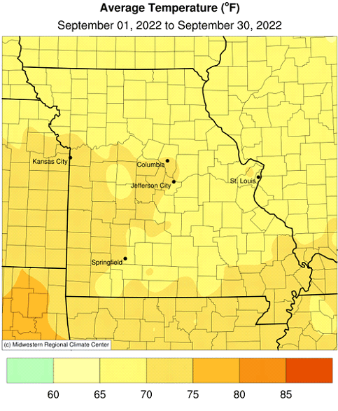
Seasonably warm conditions were the rule in September with a few brief periods of below average temperatures, especially toward the end of the month, Figure 1. The hottest weather occurred around the fall equinox when temperatures climbed well into the 90's around the state, some triple-digit heat was also reported. The southeastern community of Marble Hill, in Bollinger County, reported a high of 101°F on the 21st of the month.
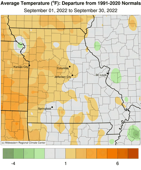
Preliminary data indicate a statewide average temperature of 69.4 °F, or 1.2 degrees above the long-term average. The mild month followed the trend over the past decade with 8 out of the past 10 Septembers hotter than average, Figure 2. It was the sixth above average month for the year, Figure 3.
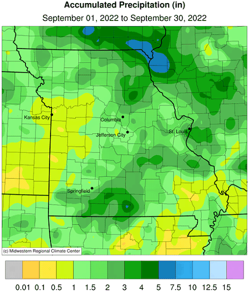
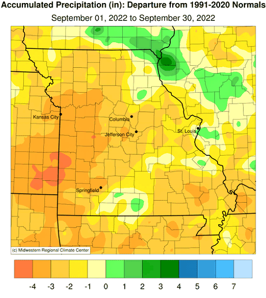
Dry conditions impacted most of Missouri in September with preliminary data indicating a statewide average of 1.60 inches, 2.50 inches below the long-term average. It was the sixth consecutive dry September for the state and ninth time in the past decade where September had below normal rainfall, Figure 4. It was also the third month this year with below average precipitation, Figure 5.
September rainfall totals were variable across Missouri with radar-estimates indicating highest amounts from northeastern Missouri and driest conditions in west central, southwestern and southeastern Missouri, Figure 6. Some of the heaviest and lightest rain gauge reports for September are listed in Table 1.
| Missouri High and Low Rainfall Extremes for September 2022* | |||
| Station Name* | County | Rainfall (in.) | |
| Heaviest | Kahoka 5.2 ESE | Clark | 6.67 |
| Dora 3SE | Ozark | 6.17 | |
| Paris 0.7 S | Monroe | 5.39 | |
| Monticello 0.4 SSW | Lewis | 5.38 | |
| Arbela 2.7 ESE | Scotland | 5.14 | |
| Lightest | Poplar Bluff 3.7 WNW | Butler | 0.33 |
| Greenville 5.2 WNW | Wayne | 0.33 | |
| Bloomfield 2.9 S | Stoddard | 0.35 | |
| Nevada 0.2 W | Vernon | 0.37 | |
| Marble Hill 6.8 E | Bollinger | 0.38 | |
| *Rain gauges are from the NWS Cooperative Network and CoCoRaHS observations. | |||
| Table 1. | |||
The U.S. Drought Monitor map for September 27, 2022 showed over half of Missouri experiencing moderate drought or worse, Figure 7. Driest conditions were occurring over west central and southwestern sections where parts of the region were experiencing severe to extreme drought, with exceptional drought conditions impacting all or portions of six counties in far southwestern Missouri (Jasper, Barton, Vernon, Cedar, Dade and Lawrence counties).
Dryness impacts continued to expand and accumulate across the state during September. Parts of west central and southern Missouri have been especially hard hit, where varying degrees dryness have persisted for much of the summer. There have been reports of significant crop and pasture losses, and dwindling feed and water supplies for livestock. Dry September conditions provided little or no opportunity for renewed grass growth for pastures and lawns statewide and seeding efforts for cool season turfgrasses were severely hampered.
According to the Missouri Agricultural Statistics Service, as of September 25, 2022, the majority of the corn crop was in fair to good condition at 27% and 42%, respectively. Remaining corn conditions this year were 6% excellent, 9% poor and 16% very poor. Corn harvest was running behind at 19%, compared to the 5-year average of 30%. The majority of the soybean crop this year was reported in fair (36%) to good (40%) condition with only 9% reported as excellent. Last year, at this time, soybean was 24% fair, 54% good and 13% excellent.
The majority of hay and roughages were adequate (61%) with 0% surplus this year and 29% short and 10% very short. Stock water supplies were mostly adequate at 62%, with 30% short and 7% very short. The majority of pastures were reported in fair (35%) to good (28%) condition with 1% in excellent condition and 20% in poor, 16% very poor condition.
The majority of topsoil moisture conditions were short (40%) and adequate (35%), while 2% were surplus and 23% very short. The subsoil moisture conditions were reported 1% surplus, 39% adequate, 37% short, and 23% very short.
Most sections of the Missouri will experience their first fall frost during October, Figure 8. Using climatology, the northern quarter of Missouri and eastern Ozarks will generally experience a light freeze (32°F or cooler) by mid-October. Central Missouri and the western Ozarks will experience a light freeze by October 21st, and a few days later in urban areas. The Bootheel will have a light freeze typically toward the end of October or early November. For more information on frost/freeze probabilities for Missouri, including additional temperature thresholds, please visit the following link: http://ipm.missouri.edu/FrostFreezeGuide.
Jump to:
- Figure 1
- Figure 2
- Figure 3
- Figure 4
- Figure 5
- Figure 6
- Figure 7
- Figure 8
- Figure 9
- Figure 10
- Figure 11
- Figure 12
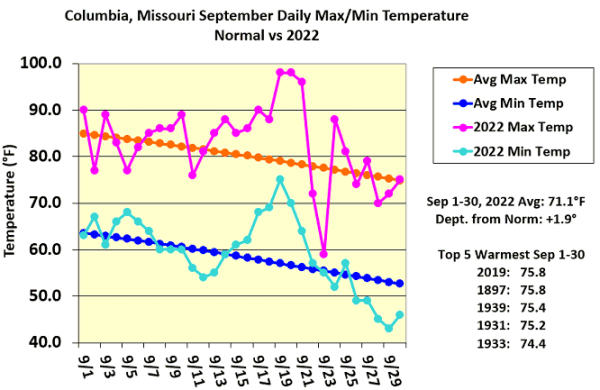
Figure 1.
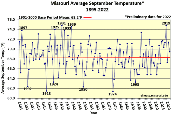
Figure 2.
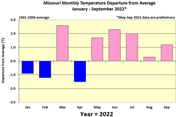
Figure 3.
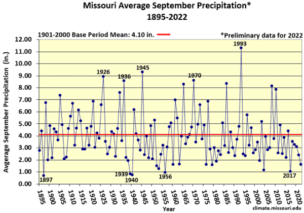
Figure 4.
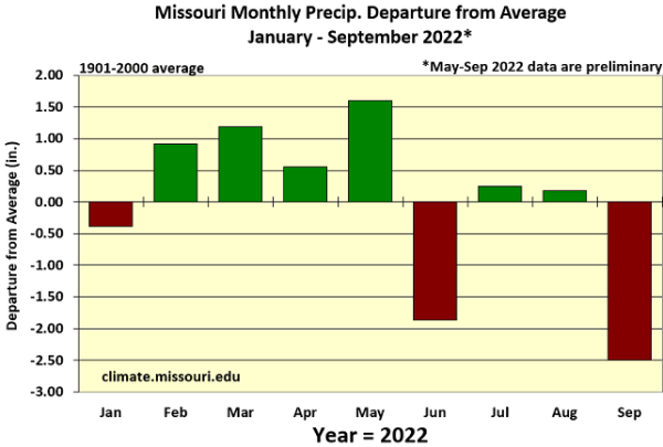
Figure 5.
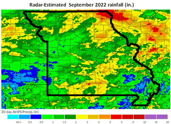
Figure 6.
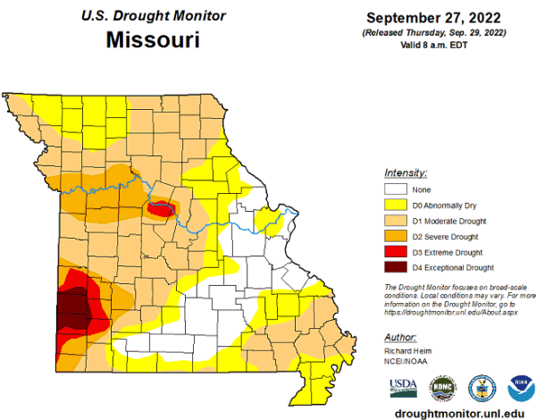
Figure 7.
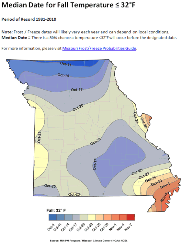
Figure 8.
Source: Pat Guinan, 573-882-5908