
September 2020 Weather and Its Impacts on Missouri
Pat Guinan
State Climatologist
University of Missouri Extension
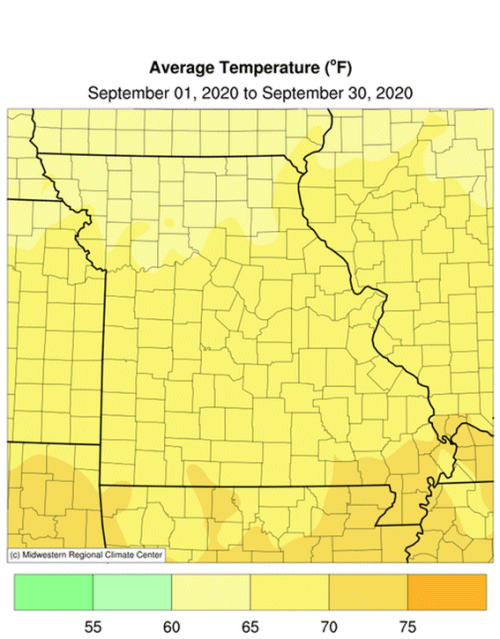
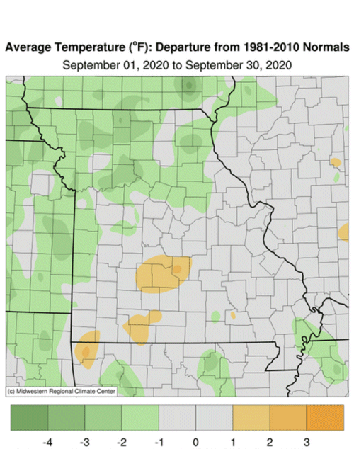
Mostly pleasant late-summer, early fall-like temperatures occurred during September with preliminary data indicating a statewide average temperature of 67.1 °F, or 1.2 degrees below the long-term average, Figure 1. It was the second consecutive cooler than average month and fourth for the year, Figure 2.
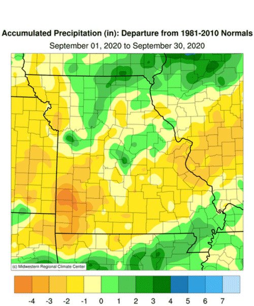
Drier than average weather impacted most of Missouri in September with preliminary data indicating a statewide average of 3.27 inches, 0.80 inches below the long-term average. It was the fourth consecutive dry September for the state and eighth time in the past decade where September had below normal precipitation, Figure 3. It was also the second consecutive dry month and fourth for the year, Figure 4.
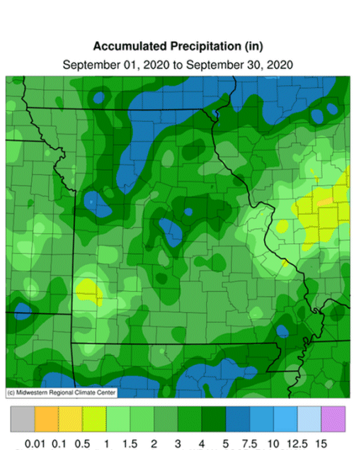
Monthly precipitation totals were highly variable across Missouri with radar-estimates indicating highest amounts in parts of west central, central, north central, northeast and far southeastern Missouri and a dry corridor extending from east central to southwestern Missouri, generally paralleling I-44, Figure 5. Another area of dryness was indicated in far northwestern Missouri. Some of the heaviest and lightest rain gauge reports for September are listed in Table 1.
| Missouri High and Low Rainfall Extremes for September 2020 | |||
| Station Name* | County |
Rainfall (in) | |
| Heaviest | Blue Springs 2.2S | Jackson | 10.49 |
| Eugene 4.8NE | Cole | 8.30 | |
| Carrollton 1.0NNE | Carroll | 6.98 | |
| Green City 5.0N | Sullivan | 6.77 | |
| Linneus 2.4ESE | Linn | 6.64 | |
| Lightest | Lamar 0.3ESE | Barton | 0.29 |
| Festus | Jefferson | 0.79 | |
| Mt. Vernon 1.3NNW | Lawrence | 0.79 | |
| Ash Grove 4.0S | Greene | 0.90 | |
| St. Louis Lambert AP | St. Louis | 0.90 | |
| *Rain gauges are from the NWS Cooperative Network and CoCoRaHS Network | |||
| Table 1. | |||
The U.S. Drought Monitor map for September 29, 2020 showed portions of Missouri experiencing abnormally dry conditions to severe drought. Driest conditions were located in southwestern Missouri where some counties have reported dry weather since early June. Impacts are mounting in the area ranging from poor crop yields, burned-up pastures, and dry springs, creeks and ponds. Some people are hauling water, but the big concern for livestock operators is they are feeding a lot of hay now and are concerned of running out before spring.
According to the Missouri Agricultural Statistics Service, as of September 28, 2020, the majority of the corn crop was in good to excellent condition at 62% and 18%, respectively. Remaining corn conditions this year were 16% fair, 3% poor and 1% very poor. Corn harvest was behind schedule at 21% compared to the 5-year average of 41%. The majority of the soybean crop this year was also reported in good (61%) to excellent (20%) condition compared to 44% good and 6% excellent at the same time last year.
The majority of hay and roughages were adequate (76%) to surplus (14%) this year with 7% short and 3% very short. Stock water supplies were mostly adequate at 91%, with 8% short and 1% very short. The majority of pastures were reported in good (47%) to excellent (7%) condition while 12% were in poor or very poor condition. The majority of topsoil moisture conditions were adequate (73%) and 0% surplus while 24% were reported short and 3% very short. The majority of subsoil moisture conditions were also reported to be adequate (76%) to surplus (0%) with 21% short and 3% very short.
Most sections of the Missouri will experience their first fall frost during October, Figure 7. Using climatology, the northern quarter of Missouri and eastern Ozarks will generally experience a light freeze (32°F or cooler) by mid-October. Central Missouri and the western Ozarks will experience a light freeze by October 21st, and a few days later in urban areas. The Bootheel will have a light freeze typically toward the end of October or early November. For more information on frost/freeze probabilities for Missouri, including additional temperature thresholds, please visit the following link: http://ipm.missouri.edu/FrostFreezeGuide.
Jump to:
- Figure 1
- Figure 2
- Figure 3
- Figure 4
- Figure 5
- Figure 6
- Figure 7
- Figure 8
- Figure 9
- Figure 10
- Figure 11
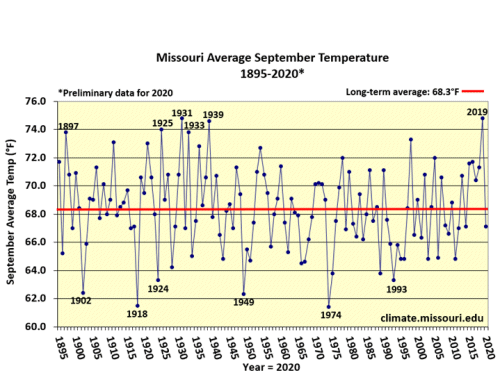
Figure 1.
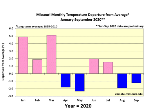
Figure 2.
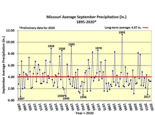
Figure 3.
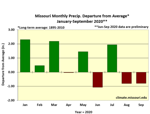
Figure 4.
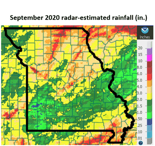
Figure 5.
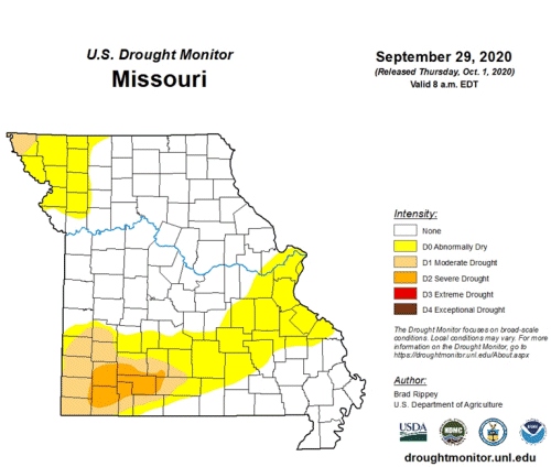
Figure 6.
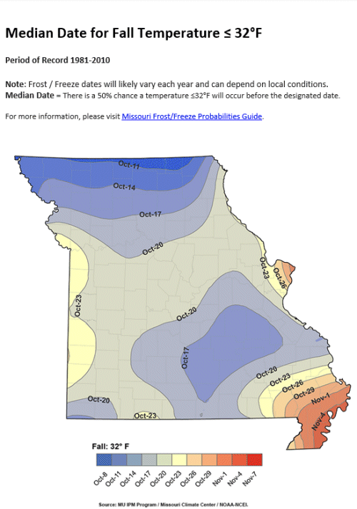
Figure 7.
Source: Pat Guinan, 573-882-5908