
September 2013 Weather and Its Impacts on Missouri
Pat Guinan
State Climatologist
Commercial Agriculture/University of Missouri Extension
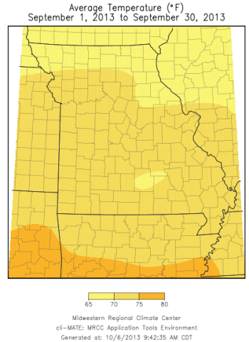
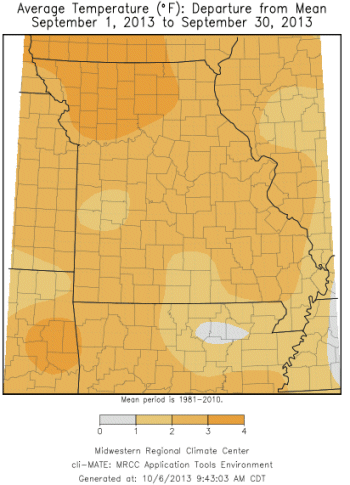
Summer-like temperatures prevailed for much of September in Missouri and resulted in the first warmer than normal month since February, Figure 1. Preliminary data indicate a statewide average temperature of 70.6°F, or 2.3 degrees above the long-term average. The abnormal warmth was especially notable during the first half of the month with high temperatures on several days reaching the 90's, Figure 2. A few locations across the northern half of Missouri broke records when unusual late-season triple digit heat was reported from September 7-11. The Kansas City Downtown Airport climbed to 102°F on the 8th of the month. There were only a handful of cooler than normal days, and no freezing temperatures were reported across the state.
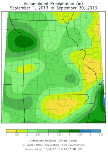
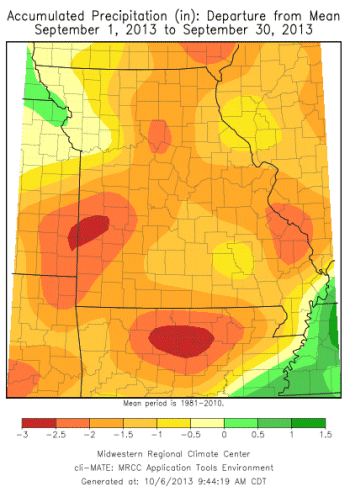
Rainfall was below normal across all of Missouri during September and averaged slightly less than 3-inches, or about 1.25 inches below normal, Figure 3. There were some notable precipitation events including one on September 1 that benefited soybeans and pastures in the northwestern tip of the state, and some west central counties. Another event on the 8th of the month brought some much needed rain to a few counties in east central Missouri. Parts of extreme northern Missouri received between 0.5-1.5 inches of rain on the 11th and 12th. The northeastern community of Edina, MO went a record 43 consecutive days, Jul 31 - Sep 11, with no measureable rainfall. The streak ended when 1.23" was reported on the 12th of the month. The longest period of unsettled weather occurred between the 15th and 21st. The heaviest and most widespread rainfall occurred on the 19th and 21st when much of the state received 0.5 to 3-inches. Parts of the Kansas City metro area experienced flash flooding during the evening of the 19th when 2-3 inches of rain fell over a short period of time. Additional rain events occurred on the 24th, 28th and 29th.
Heaviest monthly rainfall totals fell across pockets of northwestern and southwestern Missouri where 3-5 inches were common. A CoCoRaHS observer just south of Plattsburg, MO, in Clinton County, reported 6.02 inches for September. Lightest monthly totals, less than 1-inch, were observed in a few southeastern counties. A small area of dryness was also noted in southwestern Missouri where a CoCoRaHS observer just northwest of Appleton City reported only 0.89" for the month. Jackson, MO, in Cape Girardeau County, had a meager 0.59 inches.
Cooler and wetter conditions during the latter half of September re-invigorated vegetative growth, and slightly improved hydrological conditions, but much of the northern half of the state was still experiencing moderate to severe drought by the end of September according to the Drought Monitor map, Figure 4.
As of September 30th, the Missouri Agricultural Statistics Service reported 74% of the pastures in fair to good condition, and 78% of the hay supply and other roughages adequate. Cooler than normal temperatures this past summer mitigated evaporative loss and 78% of the stock water supplies remained adequate. Crop conditions across the state were mostly fair to good condition with corn at 70%, and soybean at 67%.
Jump to:
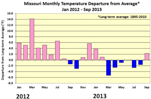
Figure 1
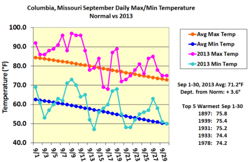
Figure 2
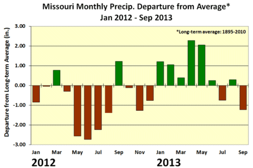
Figure 3
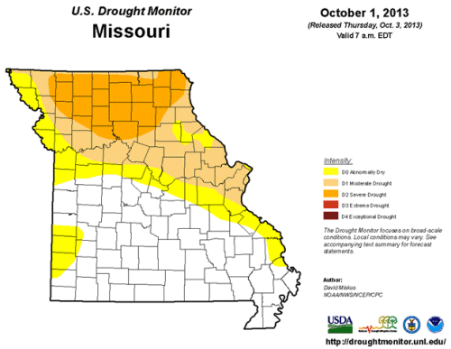
Figure 4
Source: Pat Guinan, 573-882-5908