September 2012 Weather and Its Impacts on Missouri
Pat Guinan
State Climatologist
Commercial Agriculture/University of Missouri Extension
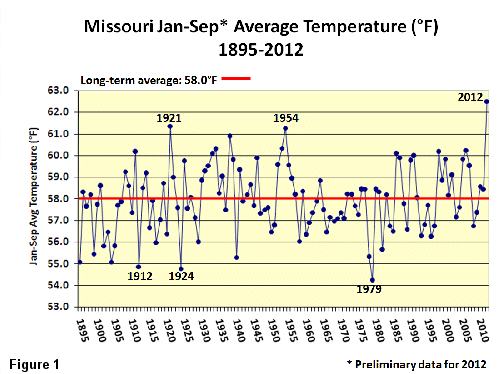
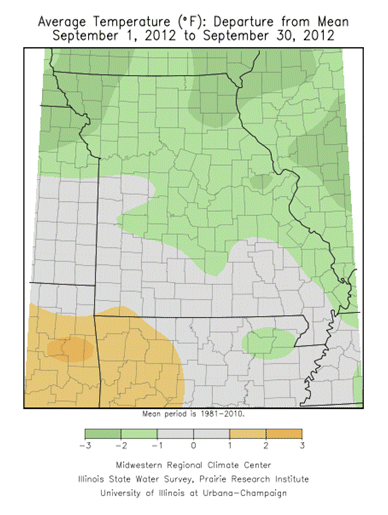
Cooler September temperatures in Missouri, in combination with some rain events, mitigated the severe drought conditions impacting the state, but by no means eliminated it. Preliminary temperature data indicate a statewide average temperature of 67.0°F, or slightly more than 1 degree F below normal. The cooler than normal month broke a string of 11 consecutive months with above normal temperatures for Missouri and was the first cooler than normal month since September 2011. Despite a cooler than normal September, the year-to-date average temperature ranks as the warmest January through September period on record for Missouri, Figure 1.
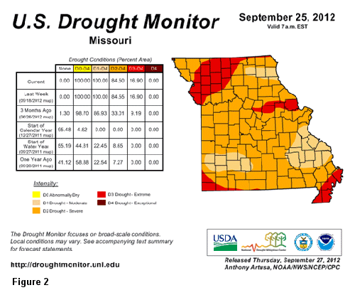
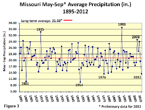
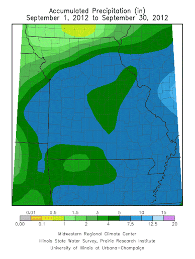
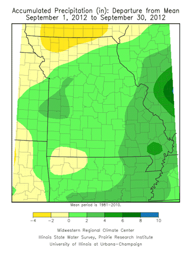
Preliminary rainfall data for September indicates an average statewide total of 5.30 inches, nearly 1-inch above normal, and only the second time this year, following March, when a month recorded above average rainfall. Remnants of Hurricane Isaac dropped widespread, significant rainfall over the state during Labor Day weekend and monthly September totals include accumulated rainfall beginning 7 a.m., August 31st through 7 a.m. September 30th, 2012. According to the Drought Monitor map, all counties in Missouri were in various stages of drought toward the end of the September, ranging from moderate drought (D1) to extreme drought (D3), Figure 2. Heaviest September totals fell across southern Missouri where 5-7 inches were common. Year-to-date statewide precipitation averaged 24.5 inches, or 8 inches below normal. Growing season rainfall, beginning May through September, averaged 13.5 inches, or 7.5 inches below normal. This year tied 1976 for the 3rd driest May through September period on record, Figure 3.
Recovery from the current drought will take time. Complete drought elimination for Missouri will require frequent, significant precipitation events as we progress through the fall season and it will take a substantial amount of water to bring conditions back to normal. Remnants of Isaac, in combination with cooler September temperatures and additional rain events have led to improvement, especially over southern sections. Moistening of the topsoil layer and greening up of pastures and lawns have occurred across the state, but more rainfall is needed to recharge surface water and groundwater supplies, and to stimulate vegetative growth prior to first fall freeze. Some of the driest conditions this month were in far northern and northwestern sections, where rainfall was below normal, and 1-2 inches were common. Unfortunately, precipitation amounts typically decline more quickly across northern sections of Missouri when transitioning from the fall to winter season, and hopefully a wetter pattern will emerge soon over the region.
According to the Missouri Agricultural Statistics Service, at the end of September, 61% of topsoil moisture in the state was in short to very short supply, and 89% of the subsoil moisture supply was reported short to very short. Additionally, 82% of the stock water supplies were reported to be in short to very short supply and 71% of the pastures were in poor to very poor condition.
Most parts of the state will experience their first fall frost during October. Using climatology, the northern quarter of Missouri and eastern Ozarks will experience a light freeze (32° or cooler) as early as October 10 on 5 out of 10 years. Central Missouri and the western Ozarks will experience a light freeze on 5 out of 10 years by October 15. The Bootheel will have a light freeze on 5 out of 10 years by October 30. A map displaying the average date of first fall frost in Missouri can be found at the following web link: http://agebb.missouri.edu/weather/frost2.htm
The 30-day outlook for Missouri for the month of October as issued by the Climate Prediction Center calls for below normal temperatures and equal chances for above, below and near normal precipitation for all of the Show Me state. Normal precipitation for Missouri during October ranges from 3.5-4.0 inches in west central and southwestern sections to between 3.0-3.5 inches in the remainder of the state except the southeastern counties where 2.75-3.0 inches are expected.