September 2011 Weather and
Its Impacts on Missouri
Pat Guinan
State Climatologist
Commercial Agriculture/University of Missouri Extension
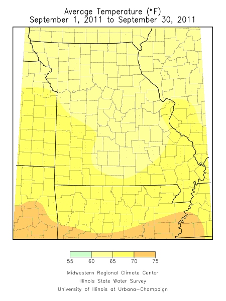
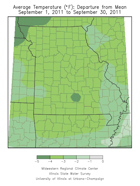
Preliminary September weather data for Missouri were indicating an average statewide temperature of nearly 3 degrees Fahrenheit below normal. Generally cool conditions were dominant over the entire state where monthly average temperatures ranged 2.5 to 3.5 degrees below normal for many locations. Some parts of the Ozarks and far northwestern Missouri had cooler departures running 3.5 to 4.5 degrees below normal for the month.
The first half of the month experienced a couple periods that were hot, but thankfully brief. Temperatures climbed into the middle and upper 90’s during the first 3 days of the month with some locations reaching the century mark. Many locations across drought stricken areas of southwestern, west central and northeastern Missouri climbed into the 100’s with Clinton, MO topping out at 105°F on September 1st. Another warm spell impacted southern sections on the 12th and 13th when temperatures climbed into the upper 80’s and 90’s. A strong cold front swept through the state during this time and effectively put an end to the hot weather.
Aside from the brief heat, temperatures were seasonably cool and pleasant during the month as high temperatures mostly climbed into the 60’s and 70’s. With few exceptions, minimum temperatures dipped into the 40’s and 50’s. No freezing temperatures were reported during the month, but the northern communities of Spickard and Monroe City dropped to 35° on the morning of September 15th. Brookfield, MO dropped to 33° during the morning of the 25th.
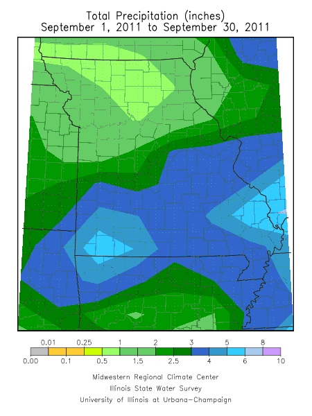
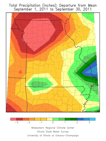
A fairly active and progressive weather pattern dominated much of the month as several frontal boundaries swept through the state and brought periods of precipitation. Most rain events, however, were not widespread, nor heavy, and preliminary data indicated an average statewide total of nearly 2.90 inches, more than 1-inch below normal for the month.
Notable rain events were confined to mostly central, east central and southeastern sections for the first half of the month, and southern Missouri during the latter half of September. Monthly rainfall increased from northern through southern Missouri with northern sections receiving 0.5-1.5 inches for the month, central sections, 1.5-3.0 inches, and southern Missouri, 3-5 inches.
Lightest monthly totals occurred across northern sections and include Monticello – 0.40”, Princeton – 0.38”, Spickard – 0.37”, and the Macon County community of Ethel where a paltry 0.06” was reported. Heaviest amounts were confined to southern Missouri and include several locations in Barry, Stone and Taney Counties with 6-9 inches, but the heaviest official total was reported in southeastern Missouri where Cape Girardeau reported 10.21 inches for the month.
According to the Missouri Agricultural Statistics Service, the generally dry weather during September hastened fieldwork activity over much of the state and allowed producers to harvest nearly two thirds of the corn by the end of the month. Soybean harvest was going at a normal pace and nearly 10% was harvested by the end of the month.
Nearly 50% of the pastures were in poor to very poor condition at the end of the month due to lingering effects of summer heat and drought that impacted west central and southwestern Missouri, emerging severe drought across northeastern sections, and abnormally dry September conditions across the rest of northern Missouri. There were numerous reports of farmers feeding hay as well as hauling water due to dry ponds, springs and creeks.
During this time of year concerns arise over the prospects of freezing temperatures occurring in Missouri. Most sections of the state will experience their first fall frost during October. Using climatology, the northern quarter of Missouri and eastern Ozarks will experience a light freeze (32° or cooler) as early as October 10 on 5 out of 10 years. Central Missouri and the western Ozarks will experience a light freeze on 5 out of 10 years by October 15. The Bootheel will have a light freeze on 5 out of 10 years by October 30. A map displaying the average date of first fall frost in Missouri can be found at the following web link: http://agebb.missouri.edu/weather/frost2.htm