October 2024 Weather and Its Impacts on Missouri
Dr. Pat Guinan |
Dr. Zachary Leasor |
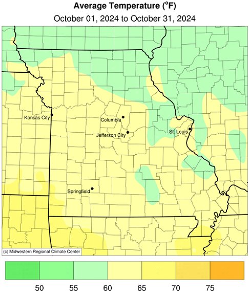
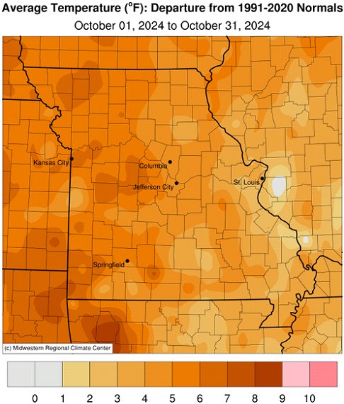
Mild weather and abundant sunshine impacted Missouri in October with preliminary data indicating a statewide average temperature of 61.6°F, 4.6 degrees above normal and 11th warmest October on record, Figure 1. It was the 7th month in 2024 with above average temperatures, Figure 2, and third warmest Jan-Oct period in Missouri since 1895, Figure 3.
Using Columbia, MO as a midpoint for the state, daily temperatures remained above normal for much of October, with a few days reporting slightly cooler than average conditions, Figure 4. Record to near-record warmth occurred on October 5th when temperatures climbed into the mid 90's across western Missouri.
Most of Missouri experienced freezing conditions in mid-October, with minimum temperatures in the mid 20's to lower 30's. Coldest weather occurred in low-lying areas of the Ozarks and a few northern locations. Temperatures remained above freezing the rest of the month and autumn colors were slow to show. Foliage remained on most shrubs and trees by the end of October.
Cloudy days were sparse in October with full-sunshine days dominating. According to Missouri Mesonet solar radiation data, and using Columbia, MO as a midpoint for the state, it was the sunniest October in more than three decades (1994-2024), Figure 5.
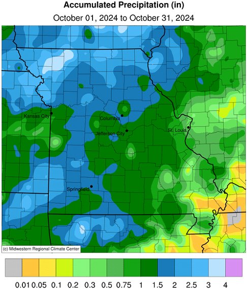
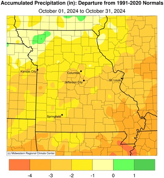
There were few precipitation events and much of the state reported below normal rainfall in October. Preliminary data indicate an average statewide total of 1.50 inches, or 1.69 inches below normal. It was the third consecutive October with drier than average weather, Figure 6, and third consecutive below average month, Figure 7. It was the driest Aug-Oct period for Missouri in 25 years, Figure 8.
According to precipitation reports, highest monthly totals of 2-3 inches fell over northwestern and far northern Missouri. A few border counties in southwestern Missouri also reported 2-3 inches. Much of the rest of the state reported 1-2 inches for the month. Driest conditions were over far southeastern sections where less than 1-inch was common. A few locations in southeastern reported no measurable rainfall for the month. Some of the heaviest and lightest rainfall reports for October are listed in Table 1.
A coronal mass ejection from the sun on October 8th caused a geomagnetic storm and made the northern lights visible across Missouri during the evening of October 10th. A beautiful display of green, purple and pink shades shimmered across the northern sky and were most vivid when taking long-exposure photographs, Figure 9.
| Missouri High and Low Precipitation Extremes for October 2024 | |||
| Station Name* | County | Precipitation (in.) | |
| Heaviest | |||
| Ridgeway 4.4NW | Harrison | 4.16 | |
| Platte City 0.3ENE | Platte | 3.64 | |
| Conception 0.7NE | Nodaway | 3.49 | |
| Albany 0.7NE | Gentry | 3.46 | |
| Savannah 0.9ENE | Andrew | 3.30 | |
| Oregon 1.3ESE | Holt | 3.11 | |
| Unionville 0.8W | Putnam | 2.94 | |
| Lightest | |||
| Hornersville | Dunklin | 0.00 | |
| Malden Municipal AP | Dunklin | 0.00 | |
| Sikeston 1.7ENE | Scott | 0.02 | |
| Lesterville 2 | Reynolds | 0.10 | |
| Marble Hill 6.8E | Cape Girardeau | 0.49 | |
| Williamsville | Wayne | 0.57 | |
| Ste. Genevieve | Ste. Genevieve | 0.61 | |
| *CoCoRaHS and National Weather Service Cooperative reports | |||
| Table 1. | |||
The dry October conditions hastened harvest and fieldwork activity around the state. Corn and soybean harvest was running ahead of schedule and crop dry-down opportunities were numerous. According to the Missouri Agricultural Statistics Service, corn and soybean harvest was 86% and 75% complete, respectively, by October 27. Topsoil and subsoil moisture conditions were mostly dry with topsoil at 41% short and 29% very short and subsoil at 42% short and 22% very short. Pasture and stock water supplies were generally adequate at 80% and 62%, respectively.
The Drought Monitor map as of October 29 indicated most of the state experiencing moderate to extreme drought, especially northern and western sections. Much of southwestern Missouri was in extreme drought, Figure 10.
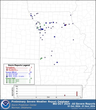
October 2024 Storm Prediction Center Severe Weather Report for Missouri
Submitted by Evan Cargill, University of Missouri
Comparison to Averages
- There is a 30-year average of three tornadoes in Missouri during the month of October. In 2024, there was just one report. There were six hail reports during October, close to the monthly average of 5.3. Finally, there were fifty-three reports of strong winds. compared to the average of 15.
Discussion
- While the number of tornado and hail reports were less than average in October, the number of severe wind reports was significantly higher. This is most likely due to squall lines moving through Missouri causing a large amount of wind damage rather than spawning tornadoes and significant hail.
Jump to:
- Figure 1
- Figure 2
- Figure 3
- Figure 4
- Figure 5
- Figure 6
- Figure 7
- Figure 8
- Figure 9
- Figure 10
- Figure 11
- Figure 12
- Figure 13
- Figure 14
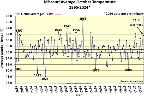
Figure 1.
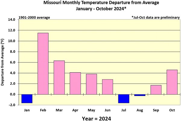
Figure 2.
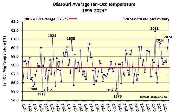
Figure 3.
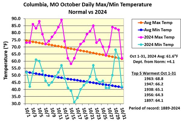
Figure 4.
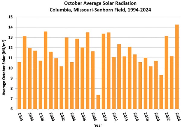
Figure 5.
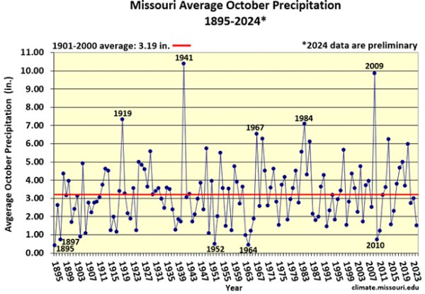
Figure 6.
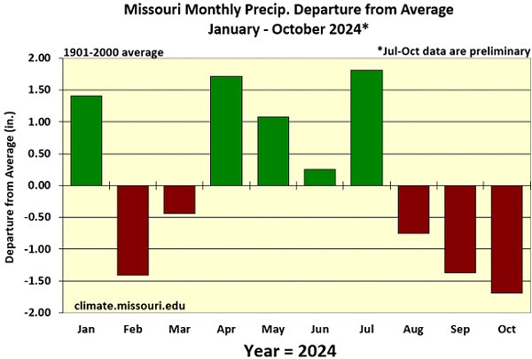
Figure 7.
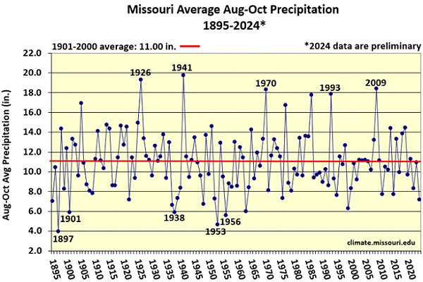
Figure 8.
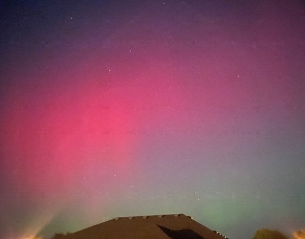
Figure 9. Northern lights during the evening of October 10, 2024, Columbia, MO.
Photo credit: Zack Leasor, iPhone.
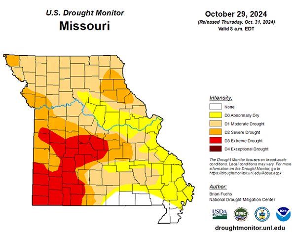
Figure 10.
Source: Dr. Pat Guinan and Dr. Zack Leasor | 573-882-5908


