November 2011 Weather and
Its Impacts on Missouri
Pat Guinan
State Climatologist
Commercial Agriculture/University of Missouri Extension
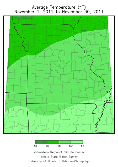
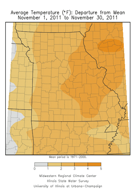
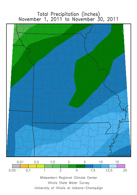
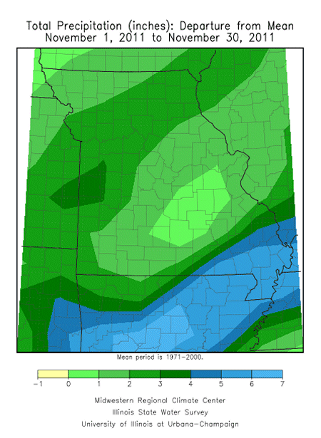
Mild and wet conditions prevailed in Missouri during November with preliminary data indicating temperatures averaging two degrees above normal and precipitation just over two inches above normal for the month. The average statewide November temperature and precipitation was 47°F and 5.71 inches, respectively.
Generally, much of the state received 4-6 inches of precipitation, but lighter amounts were reported across portions of northwestern Missouri where 3.5-4.0 inches were common. Rock Port, in the northwestern tip of the state, reported only 2.53 inches for the month, which is still nearly 1-inch above normal. Additionally, a 100-mile wide corridor of 3-4 inches occurred from Houston, in Texas County, northeastward to St. Louis. Heaviest precipitation occurred in far southeastern sections, especially in the Bootheel region, where 9-11 inches were common. Preliminary reports indicate it was the wettest November for the Bootheel since 1973, and the 3rd wettest on record. The Farm Service Agency office in Poplar Bluff reported 12.50 inches for the month.
Despite inclement weather conditions during the month, temperatures were seasonable to above normal on most days, reaching the 50’s and 60’s on most occasions. Minimum temperatures dipped mostly into the 30’s and 40’s. Warmest and coldest conditions occurred on the first and last day of the month, respectively. High temperatures peaked into the mid and upper 70’s on the first of the month and bottomed out in the mid teens to twenties on the 30th. Some locations managed to avoid a hard freeze for much of the month, as evidenced by roses still blooming toward the end of November.
A rare November snow event blanketed portions of the Bootheel with 2-6 inches of snow falling between the afternoon hours of the 28th and into the early a.m. hours of the 29th. A small but intense band of heavy snow impacted far northeastern Arkansas northeastward into portions of Dunklin, Pemiscot, Butler, Stoddard and New Madrid Counties. A CoCoRaHS observer residing 6 miles south-southwest of Gideon, in extreme northwestern Pemiscot County, reported 6.3 inches of snow on the ground during the a.m. hours of November 29th. It was the heaviest November snow event for the Bootheel in 36 years, when similar snow totals were reported on November 30th, 1976.
Even though precipitation was excessive across far southeastern sections, the above normal precipitation was welcomed over drought affected northern, central, and southwestern Missouri. Water resources above and below the ground benefited from the precipitation events, and drought conditions improved markedly according to the National Drought Mitigation Center’s Drought Monitor map: http://droughtmonitor.unl.edu/monitor.html
