April 2011 Weather and Its Impacts on Missouri
Pat Guinan
State Climatologist
Commercial Agriculture/University of Missouri Extension
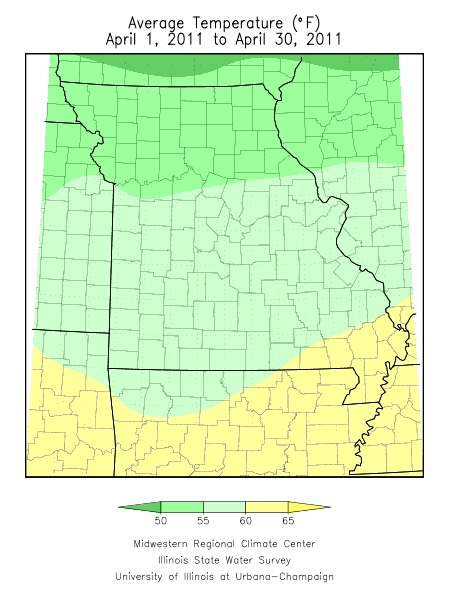
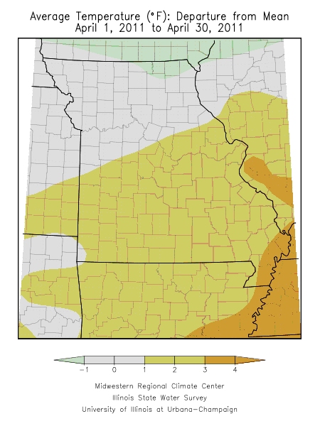
Preliminary data from Missouri indicated temperatures averaged around 2 degrees above normal for the state but high variability during the month masked some unusually warm and cool periods. In fact the first half of April was warmer than the latter half of the month.
A very mild weather pattern dominated during the first two weeks of the month when temperatures for the period averaged 5-7 degrees above normal across the state. Cooler conditions prevailed during the last two weeks of the month with more variability in temperature departures due to a frontal boundary languishing across the region. Temperatures across northern Missouri averaged 5-7 degrees below normal during the latter half of the month, 2-4 degrees cooler than normal over central sections and 1-2 degrees below normal in southern Missouri.
Numerous high temperature records occurred on April 3-4 and April 9-10 when several locations experienced maximum temperatures in the mid to upper 80's and lower 90's. Some notable temperature records include 90°F at St. Louis on the 3rd and 4th, and 89°F at Columbia on the 3rd and 4th. Kansas City smashed their temperature record on the 3rd by 9 degrees when the mercury climbed to 91°F. St. Joseph bettered their high temperature mark by an amazing 10 degrees on the 3rd when it topped out at 93°F. St. Joseph also recorded record warmth on the 9th and 10th when the mercury climbed to 88°F on both days. Springfield, Joplin, Vichy/Rolla and West Plains all broke maximum temperature records on the 3rd and 4th when highs reached the middle and upper 80's.
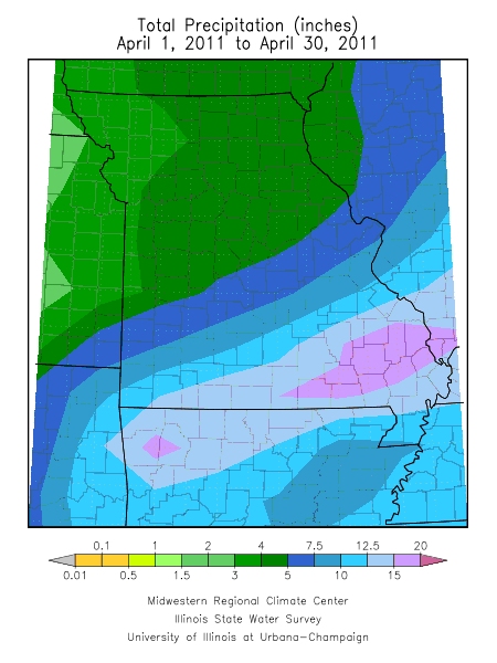
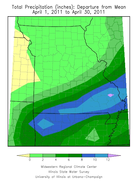
There were numerous precipitation events during the month including a week long historic rain event across southern Missouri that brought record rainfall and flooding to the region. Overall, preliminary data indicated an average monthly rainfall of 8 inches for the state, making it the 3rd wettest April in the past 117 years. Only 1994 and 1927 were wetter when April precipitation averaged 9.86 and 8.76 inches, respectively. Most counties across southern Missouri recorded their wettest April on record. Generally, more than a foot of rain fell southeast of a line extending from Newton to Sainte Genevieve counties. Some southeastern locations in Shannon, Carter, Butler and Cape Girardeau counties reported more than 20 inches of rain for the month. The southeastern community of Poplar Bluff reported a whopping 21.39 inches during April.
The majority of precipitation across southern Missouri fell from April 21-27 and resulted in major flooding and hardship across the region. A stalled frontal boundary over southern Missouri was a catalyst for waves of heavy rainfall to impact the region on a daily basis. Poplar Bluff experienced six consecutive days with an inch or more of rain - a highly unusual occurrence. Specifically, from April 22-27, Poplar Bluff received 18.10 inches. Rivers and streams rapidly climbed out of their banks inundating roads, residences and flooding hundreds of thousands of acres of farmland.
A steep gradient of precipitation fell across Missouri during the month ranging from 400% of normal across southeastern sections to near 100% of normal across northern and central sections. Amounts totaling 3-4.5 inches were common across northern and central sections, especially northwest of a line extending from 50 miles south of Kansas City through Columbia to Bowling Green, MO. Lightest totals were confined to some northwestern communities where 2.5-3.0 inches were reported. In Holt County, Mound City reported only 2.38 inches for the month.
In addition to flooding, severe thunderstorms with tornadoes impacted the state during the month with the majority of hail, wind damage and tornado reports affecting the southeastern half of the state during the latter half of the month.
The most notable severe weather event occurred on Good Friday, April 22nd, and impacted the greater St. Louis metropolitan area. An EF4 tornado touched down on the northern edge of Creve Coeur Lake just before 8 p.m. and tracked continuously eastward for 22 miles through Maryland Heights, Bridgeton, St. Ann, Edmundson, Lambert St. Louis International Airport, Berkeley, Ferguson, and over the Mississippi River into Granite City, IL. The community of Bridgeton experienced the most severe damage where National Weather Service surveys indicated EF4 damage occurred. Remarkably, no fatalities occurred with this or other tornadoes in the region that day, due in part to advanced warning and widespread media attention. Lambert International Airport incurred substantial damage to the main terminal building and Concourse C and was closed for the first time since the Blizzard of January 1982. It was the strongest tornado to impact St. Louis County since January 24, 1967.
The cool, wet weather during the latter half of the month halted spring planting opportunities across the state. According to the Missouri Agricultural Statistics Service, spring tillage at the end of the month was 50% complete and 8 days behind average. Just under a third of the corn crop had been planted and was 10 days behind normal. Replanting was going to be necessary with water standing in numerous fields across the state.