
February 2021 Weather and Its Impacts on Missouri
Pat Guinan
State Climatologist
University of Missouri Extension
After what was appearing to be another mild winter for Missouri, Mother Nature had a different plan for February. Early in February, the polar vortex migrated from near the North Pole to southern Canada and the north central U.S. bringing exceptionally cold temperatures and wind chills to the central U.S., from North Dakota to Texas, Figure 1. Temperature departures in Missouri for the 2-week period, February 6-19, 2021, averaged more than 20 degrees below normal, Figure 2, with a statewide average temperature of 10.2°F, Figure 3. Preliminary data indicate it was the coldest 2-week period to impact Missouri in over 30-years.
The last time a colder 2-week period occurred in Missouri was 1989, between Dec 11-24. Statewide temperature departures during the 1989 cold wave were also more than 20 degrees below normal, Figure 4, and the statewide average temperature for the 2-week period was 8.5°F, Figure 5. The coldest 2-week period on record for Missouri occurred during an extreme cold wave in late January and February 1899, when the statewide average temperature for the 2-week period, Jan 31-Feb 13, was a bone-chilling 4.5°F, and chunks of ice were reported flowing from the Mississippi River into the Gulf of Mexico.
Minimum temperatures during the 2021 cold wave occurred during the morning of February 16th, with many locations reporting record-breaking double-digit temperatures below 0°F, especially across the western and northern half of the state, Figure 6. The core of the coldest air impacted western and northern Missouri where a fresh snowpack, clear skies and calm conditions resulted in an extremely cold morning, Table 1. Two locations in northwestern Missouri, Corning (Atchison Co.) and Smithville Lake (Clay Co.) reported morning low temperatures of -26°F on the morning of the 16th.
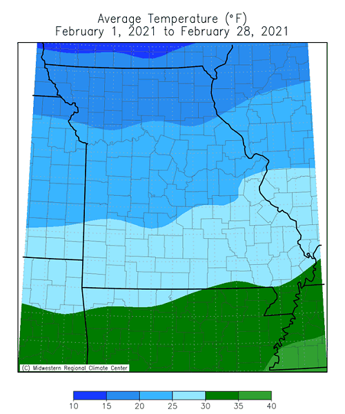
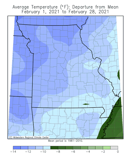
Seasonably mild days during the beginning and toward the end of February, Figure 7, slightly moderated the overall statewide average temperature for all of February, but it was still a much below average month. Preliminary data indicate a statewide average temperature of 23.5°F, or 10 degrees below the long-term average. It was the coldest February since 1979 and ranked as the 7th coldest February on record, Figure 8. The rankings could change if the month turns out to be slightly cooler than the current estimate.
Even though the two previous months, December and January, were mild, Figure 9, the extreme 2-week cold wave in February resulted in a below average meteorological winter for the Show Me State, and the first cooler than average winter in six years, Figure 10.
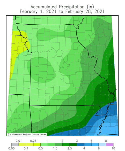
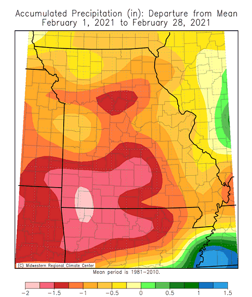
Preliminary precipitation data indicated a statewide average monthly total of 1.41 inches, or 0.64 inches below the long-term average. It was the first drier than average February in four years, Figure 11. Lightest monthly totals were generally between 0.5-1.0" and fell over the western half of the state. The precipitation gradient increased heading eastward and southeastward through the rest of the Missouri, ranging from 1-3 inches. Heaviest totals were in the Bootheel, from 3-4 inches. Winter precipitation (Dec-Jan-Feb) was slightly below average, with only January wetter than usual, Figure 12. It was also the first drier than average winter in four years, Figure 13.
The cold weather translated to most precipitation events falling in the form of snow, and above normal snowfall reported statewide, ranging from 6-14 inches for the month, Figure 14. A CoCoRaHS observer just south of Kirksville reported 15.9 inches for February. Visible satellite pictures taken on February 20, 2021, indicated all of Iowa, Illinois and Missouri under a blanket of snow, an unusual occurrence, Figure 15.
Impacts were numerous with the anomalously cold February temperatures not seen in more than a generation. Energy consumption was unusually high and reflected in consumer's home heating bills. Cold stress on outdoor workers, exposed livestock and pets was unrelenting, especially with wind chills dropping to -30°F. Ranchers were challenged with keeping newborn calves warm, feeding hay and routinely chopping ice-covered ponds for water. Dock damage due to freezing and thawing of ice on lakes was also reported and the extended period of cold weather contributed toward a deeper frost line than usual in the soil with numerous instances of frozen and broken pipes reported.
With spring around the corner, farmers and gardeners are likely thinking about planting. University of Missouri Extension, in collaboration with MU Integrated Pest Management, developed a Missouri Frost Freeze Probabilities Guide. Median dates for the last hard freeze in Missouri (≤24°F) range from March 4 (extreme southeast Missouri) to April 3 (MO/IA border), Figure 16.
Jump to:
- Figure 1
- Figure 2
- Figure 3
- Figure 4
- Figure 5
- Figure 6
- Table 1
- Figure 7
- Figure 8
- Figure 9
- Figure 10
- Figure 11
- Figure 12
- Figure 13
- Figure 14
- Figure 15
- Figure 16
- Figure 17
- Figure 18
- Figure 19
- Figure 20
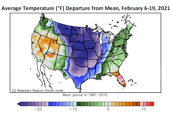
Figure 1.
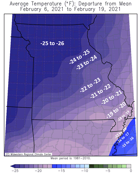
Figure 2.
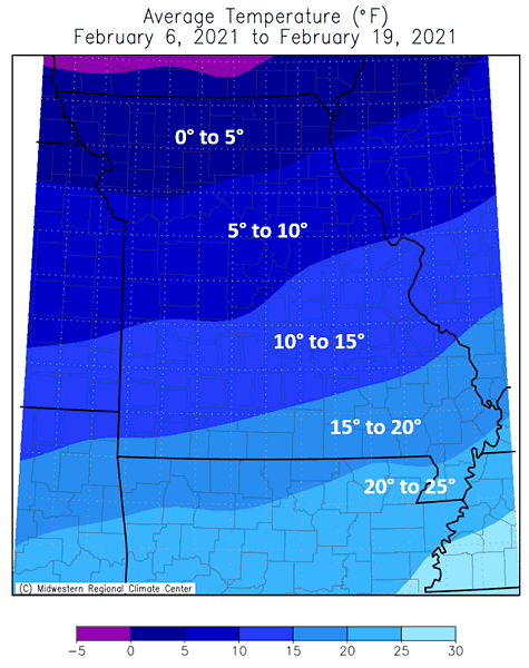
Figure 3.
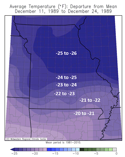
Figure 4.
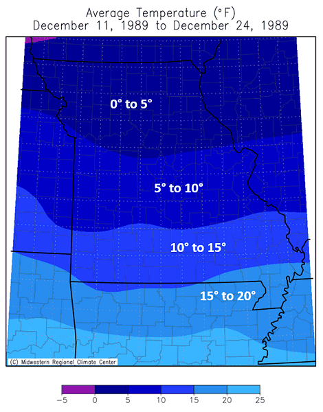
Figure 5.
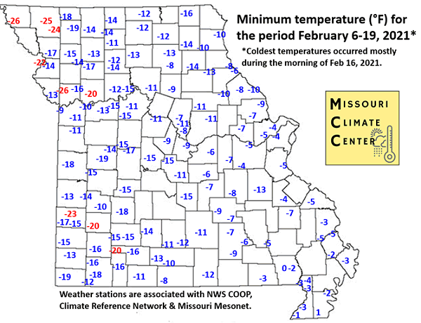
Figure 6.
| February 2021 Minimum Temperature Extremes* | |||
| Station Name* | County |
Min Temp (°F) | Date |
| Corning | Atchison | -26 | 2/16 |
| Smithville Lake | Clay | -26 | 2/16 |
| Maryville 2E | Nodaway | -25 | 2/16 |
| Conception | Nodaway | -24 | 2/17 |
| Lamar 7N | Barton | -23 | 2/16 |
| St. Joseph Airport | Buchanan | -22 | 2/16 |
| Billings 1SW | Christian | -20 | 2/16 |
| Lockwood | Dade | -20 | 2/16 |
| Richmond | Ray | -20 | 2/16 |
| *Reports are from the NWS Cooperative Network and Missouri Mesonet | |||
| Table 1. | |||
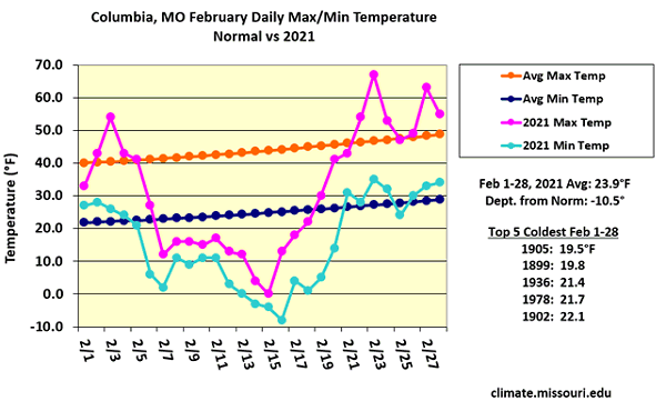
Figure 7.
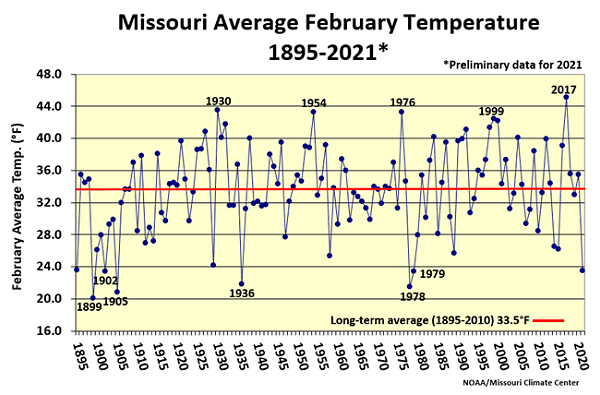
Figure 8.
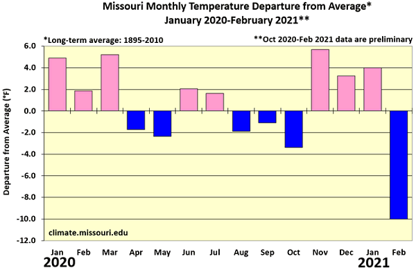
Figure 9.
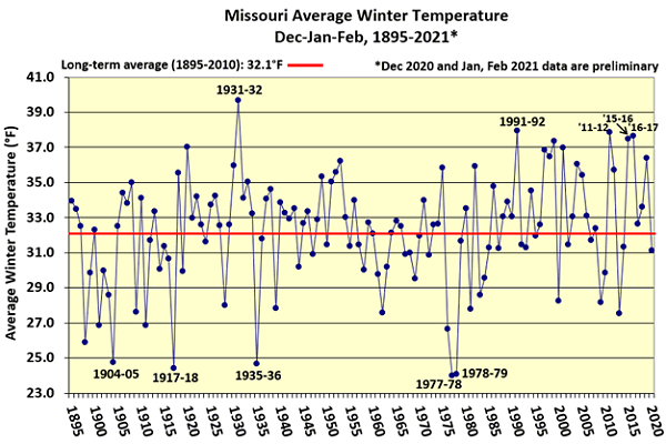
Figure 10.
Figure 11.
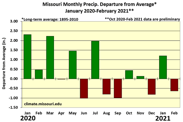
Figure 12.
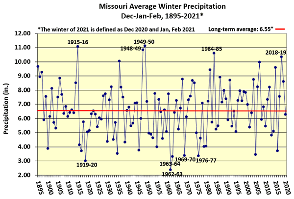
Figure 13.
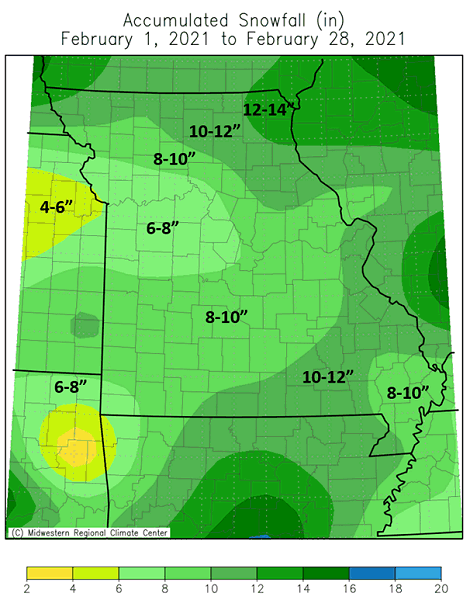
Figure 14.
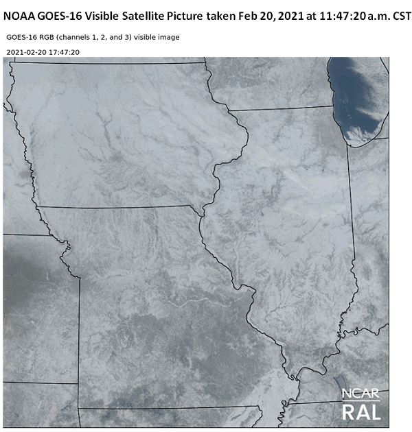
Figure 15. Snow covers all of Iowa, Illinois and Missouri
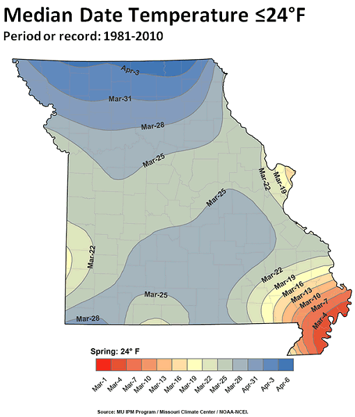
Figure 16.
Source: Pat Guinan, 573-882-5908