
February 2019 Weather and Its Impacts on Missouri
Pat Guinan
State Climatologist
University of Missouri Extension
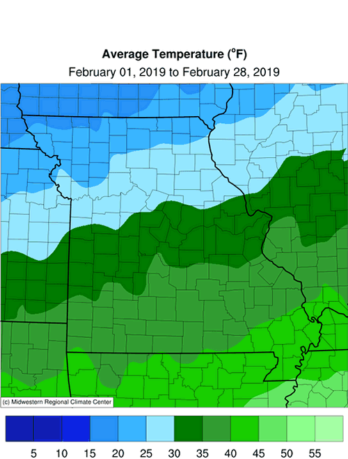
Highly contrasting temperatures impacted Missouri during February with cold and below normal conditions over the northern half of the state and near to above average temperatures over the southern half of Missouri. A strong polar jet stream, oriented southwest to northeast, bisected the state during the month and resulted in amazing temperature disparities. For example, the average February temperature in the far northwest corner of the state, Atchison County, was 18.6�, while Pemiscot County, in the southeastern tip of the Bootheel, averaged a balmy 43.6�F, Figure 1. The twenty-five degree temperature difference was highly unusual, since the average temperature difference in February between both counties is 11 degrees.
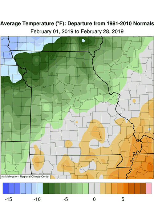
Preliminary data indicate an average statewide monthly temperature of 31.8�F, nearly two degrees below the long-term average, Figure 2. A retreating arctic air mass at the beginning of February was quickly replaced with unusually mild weather and resulted in the warmest and coldest daily temperature extremes occurring in the same week, Tables 1 and 2.
February was the first colder than average month for the winter season, Figure 3. The preliminary average winter temperature (Dec-Jan-Feb) for Missouri was 33.2�F, about 1 degree above the long-term average, Figure 4.
| February 2019 Minimum Temperature Extremes* | |||
| Station Name* | County | Min Temp (°F) | Date |
| Kirksville | Adair | -8 | 2/1 |
| Memphis | Scotland | -8 | 2/1 |
| Shelbina | Shelby | -8 | 2/1 |
| Green City | Sullivan | -7 | 2/1 |
| Unionville | Putnam | -7 | 2/1 |
| *Reports are from the NWS Cooperative Network | |||
| Table 1. | |||
| February 2019 Maximum Temperature Extremes* | |||
| Station Name* | County | Min Temp (°F) | Date |
| West Plains | Howell | 76 | 2/5 |
| Ozark Beach | Taney | 75 | 2/5 |
| Eminence 1N | Shannon | 74 | 2/5 |
| Winona | Shannon | 74 | 2/5 |
| Ava | Douglas | 73 | 2/4 |
| *Reports are from the NWS Cooperative Network | |||
| Table 2. | |||
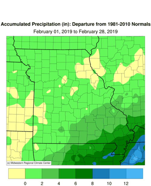
Wet winter weather continued into February with preliminary data indicating a statewide average monthly total of 3.62 inches, or 1.57 inches above the long-term average, Figure 5. It was the third consecutive month with wetter than average conditions, Figure 6, and wettest winter in 35 years, Figure 7. The winter of 2018-19 ranks as the 5th wettest winter on record for the Show Me state.
Exceptionally wet conditions were observed across southeastern Missouri, especially in the Bootheel region, where average winter precipitation approached 20-inches. Preliminary data indicate it was the 4th wettest winter on record for the Missouri Bootheel and wettest winter since 1949-50. There were numerous reports of flooded roads and fields across far southeastern Missouri. Some of the heaviest February and winter precipitation totals are listed in Table 3, and are confined to the Missouri Bootheel.
| February 2019 and Winter (Dec 2018, Jan-Feb 2019) Precipitation Reports (inches) | |||
| Location | County |
Feb Precip | Winter Precip |
| Steele 6W | Pemiscot | 13.35 | 22.33 |
| Hornersville | Dunklin | 12.74 | 22.53 |
| Cardwell | Dunklin | 11.91 | 20.63 |
| Senath 2NE | Dunklin | 11.79 | 20.50 |
| Portageville | Pemiscot | 11.57 | 20.87 |
| Hayward 1.5E | Pemiscot | 11.52 | 20.05 |
| Clarkton 1.5N | Dunklin | 10.05 | 18.38 |
| Charleston 5S | Mississippi | 10.02 | 18.28 |
| *Reports are from the NWS Cooperative Network and Missouri Mesonet | |||
| Table 3. | |||
A couple notable winter weather events occurred during the month with a mixed bag of freezing rain, sleet and snow occurring during both events. Travel and outdoor conditions were hazardous. The first event impacted a sizeable portion of the state on Feb 15-16. Heaviest daily accumulations of 3-6 inches were reported across portions of northwest, west central and central Missouri. The other event impacted mostly west central and northwestern Missouri on Feb 19-20, with 5-7 inches of snow reported in the northwestern tip of the state. Monthly snowfall accumulations were heaviest in the northwest corner of Missouri where 10-15 inches were common, Figure 8.
For the northern half of Missouri, it was the snowiest winter since 2010-11, Figure 9. Snowfall accumulations starting Oct 1, 2018 thru Feb 28, 2019, ranged from 25-35 inches across the area, and are above average for the period, Figure 10. Amounts in far northwestern Missouri were over 40 inches. Below average snowfall was reported across southern Missouri where less than 10-inches were observed for the same period.
The cold and snowy conditions across the northern half of the state translated to higher than usual energy consumption and hardship for outdoor workers, exposed livestock and pets. Some ranchers dealt with chopping ice for livestock due to frozen ponds.
Wet weather conditions this winter across much of the Missouri and Mississippi River basins have increased the likelihood for spring flooding, Figure 11. Abundant snowpack over the northern and central Plains and upper Midwest, elevated river levels, and moist soil profiles have increased the threat for significant flooding across the region, especially if above normal precipitation persists into spring.
With spring around the corner, farmers and gardeners are likely thinking about planting. University of Missouri Extension, in collaboration with MU Integrated Pest Management, developed a Missouri Frost Freeze Probabilities Guide. Median dates for the last hard freeze in Missouri (≤24°F) range from March 4 (extreme southeast Missouri) to April 3 (MO/IA border), Figure 12.
Jump to:
- Figure 1
- Figure 2
- Figure 3
- Figure 4
- Figure 5
- Figure 6
- Figure 7
- Figure 8
- Figure 9
- Figure 10
- Figure 11
- Figure 12
- Figure 13
- Figure 14
- Figure 15
- Figure 16
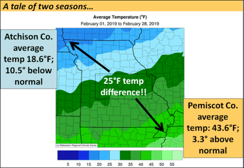
Figure 1.
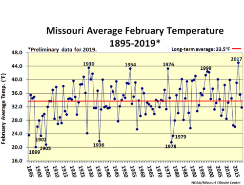
Figure 2.
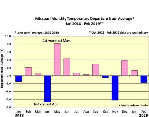
Figure 3.
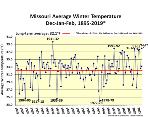
Figure 4.
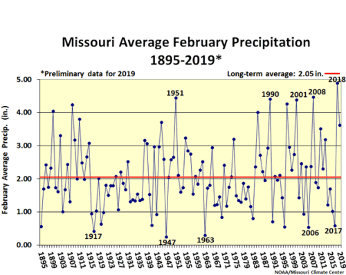
Figure 5.
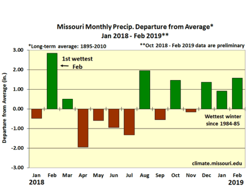
Figure 6.
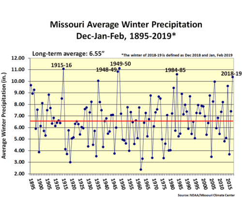
Figure 7.
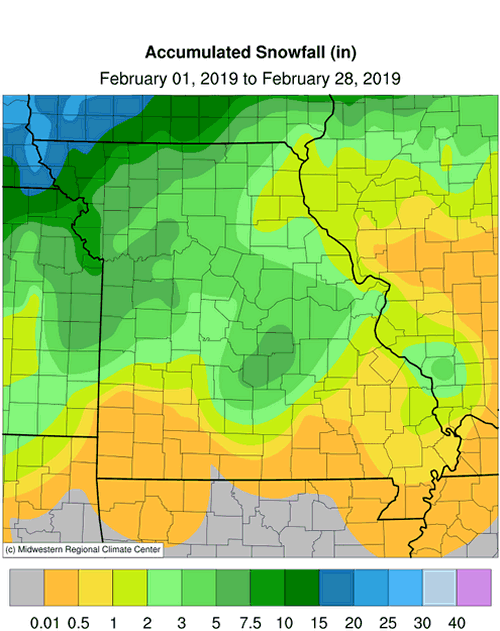
Figure 8.
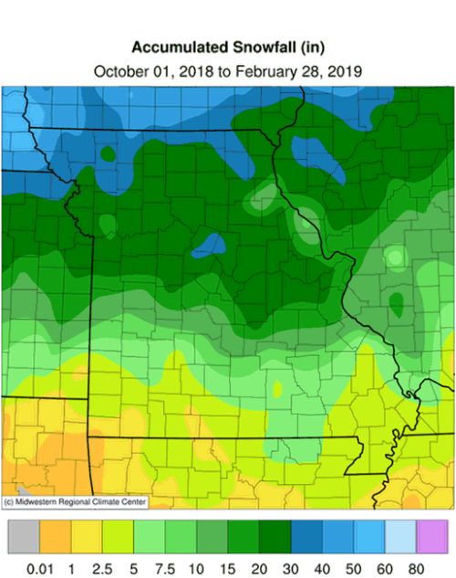
Figure 9.
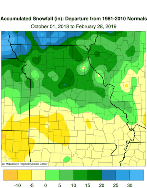
Figure 10.
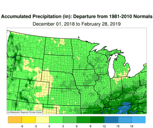
Figure 11.
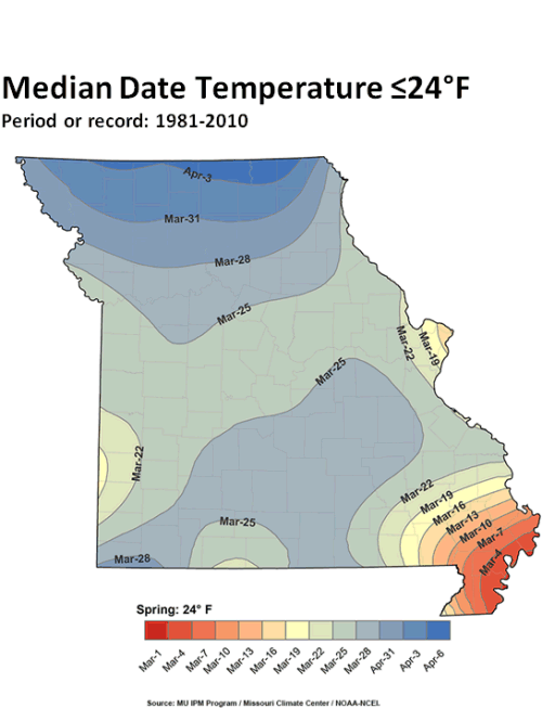
Figure 12.

Source: Pat Guinan, 573-882-5908