
Making Good Management Decisions
MU Extension researchers create automated system to track precipitation
Story by: Logan Jackson
February 10, 2017
Nearly five years ago, the Missouri Department of Natural Resources (MDNR) revised its CAFO regulatory rules for catastrophic and chronic weather events.
CAFOs, concentrated animal feeding operations, are large animal agricultural facilities that raise a specific number of animals in production barns or confinement pens. Because catastrophic and chronic weather events happen, MDNR can issue a permit to a farmer to help with the management of that farmer's facilities. Not only do farmers have the ability to manage their facilities, they have a responsibility to manage them. Farmers must comply with those regulatory rules or face fines or other penalties.
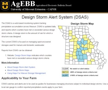 |
| The homepage of the Design Storm Alert System website. |
Managing those CAFOs is key. With more than 500 permitted CAFOs across the state, a handful of University of Missouri Extension researchers have combined their efforts to create an automated system to track precipitation accumulations across the state. The Design Storm Alert System (DSAS) is focused on providing information and data so that farmers can be more proactive with their management strategies. The system sends stakeholders alerts if a certain county is experiencing a catastrophic or chronic weather event.
"Our goal was to help to mitigate a catastrophic situation where a farmer's water containment facility could breach or overtop," said Pat Guinan, state climatologist and MU Extension associate professor. "We want these individuals to have an awareness that these weather events are occurring."
Guinan said climate data has shown an increase in heavy precipitation events in the Midwest over the past few decades. The DSAS uses the MDNR wet weather regulation criteria, the AHPS Precipitation Analysis and the NOAA Atlas 14, Volume 8. It was unveiled last year.
The DSAS uses past weather data for its assessments as well. The MU group identifies extreme precipitation events over various time periods using a radar analysis provided by the National Weather Service. The radar breaks the state into grid points - with 11,000 grid points in Missouri alone. If any grid point in a county reaches 90 percent or greater of the precipitation frequency criteria, the county will be activated for a watch or alert status.
Joining Guinan in developing the system was Ray Massey, extension professor, department of agricultural and applied economics; John Lory, extension associate professor, Division of Plant Sciences; Joe Zulovich, extension assistant professor, commercial agricultural engineer/livestock housing systems; and John Travlos, system administrator-expert, agricultural economics, MU Extension.
"There's so much information coming at you," Massey said. "Our thought was - can we put everything in a package where we've already done the work for you? We have been able to put that package together. We've divided one number by another number and given them the factor that they need.
"They would have had to go to a very specific place to get one of the numbers, then to another very specific place to get the second number. Then they would have to divide it. They would have to do that every day. We've done that work for them, and, hopefully, made it easier for them to gather that data."
The various stakeholders include farmers, as well as MDNR. Farmers generally call MDNR to see if they are in a catastrophic or chronic weather event when those situations occur. MDNR then advises the farmer as to whether or not they are in an event and what the regulations say they are allowed to do.
It's important for farmers to be aware of these weather events, as nutrient loss and runoff can be a big problem for animal feeding operations.
"With a lot of these structures, they're designed to handle so much precipitation," Zulovich said. "Having this data has a huge impact for farmers, as they can be better prepared for when these weather events happen."
"It's very similar to balancing your checkbook. Money comes in and money goes out. Do we check it every day? Not usually. If it looks tight, you'll check it more regularly. If it doesn't look tight, you'll ignore it until the end of the month. This system helps farmers make good management decisions. If they are getting a lot of rain, then they will probably check it more often. If things are going smoothly, they won't check it as often." Ray Massey, extension professor, department of agricultural and applied economics
The NOAA Atlas provides gridded precipitation frequency estimates, which were used to calculate an average for each county using specified design storm periods. For example, for a 25-year, 24-hour storm in Boone County, it translates to just less than six inches of precipitation. So, if any location in Boone County receives close to six inches of precipitation in a 24-hour period, that storm can be identified as an event that occurs about once every 25 years for that location.
"The alert system that we've developed looks at the radar estimated accumulation for each of the design storm periods and compares it to the NOAA Atlas," Guinan said. "If that radar estimate reaches or exceeds the precipitation frequency estimates provided by NOAA, then it triggers an alert. Any stakeholder will then receive an automated email alert that identifies the design storm."
The system also benefits MDNR, as they become aware of a possible event.
"By sending the alert out, we're alerting farmers that there is a concern and you have a right and responsibility to talk to DNR about your options," Massey said. "By alerting DNR, we're letting them know that they might get some phone calls.
"We think this information will help farmers understand what they can do. The weather event doesn't just affect you the week you get it, either. It will affect you months after because your facility may be full. We want to help farmers with their short-term and long-term thinking."
The system is based purely on radar estimated precipitation, so it's important to note the totals are approximate and not absolute. It's a valuable tool, though, as it keeps farmers in the know about extreme weather events.
"It's very similar to balancing your checkbook," Massey said. "Money comes in and money goes out. Do we check it every day? Not usually. If it looks tight, you'll check it more regularly. If it doesn't look tight, you'll ignore it until the end of the month.
"This system helps farmers make good management decisions. If they are getting a lot of rain, then they will probably check it more often. If things are going smoothly, they won't check it as often."
The goal is to bring the system to other areas of agriculture as well.
"We feel as though there are opportunities to go beyond what we're doing now," Guinan said. "These storm events affect other sectors, and we think we can apply this tool to those sectors."
The DSAS is a free tool. Interested individuals need to register to receive the alerts. Anyone can sign up to receive the "Design Storm Report" online.
For more information on DSAS, please visit the DSAS information website, or contact Guinan at (573) 882-5908 or GuinanP@missouri.edu.
Original story posted here.
Source: Pat Guinan, 573-882-5908