
February 2013 Weather and Its Impacts on Missouri
Pat Guinan
State Climatologist
Commercial Agriculture/University of Missouri Extension
The mild winter regime came to end in mid-February with a significant weather pattern change, and two major snow storms impacting the Show Me state. Temperatures during the first half of the month averaged 4-7°F above normal, but a shift in the jet stream during the latter half of February, translated to cold air incursions and temperatures averaging 5 to 9°F below normal. Overall, preliminary data indicate the statewide monthly average temperature was 33.6°F, or 1.5°F below normal.
Precipitation averaged above normal across most areas of the state, with preliminary data indicating a statewide average of 3.32 inches, or 1-inch above normal for February. This was the first time since Nov-Dec 2011 when two consecutive months recorded above normal precipitation. Regionally, the southeastern 2/3 of the state received 3-4 inches of precipitation, with some counties in far south central and southeastern sections reporting 4-5 inches. Heaviest monthly totals were reported in the Bootheel where locations in Butler, Dunklin and Pemiscot counties reported 5.08, 5.30 and 6.08 inches, respectively. Less than 3-inches of precipitation fell across northwestern sections, with the northwestern tip receiving the least amount. Below normal precipitation, or generally less than 1-inch, was reported across DeKalb, Holt, Andrew and Nodaway counties where locations reported 0.69, 0.52, 0.51, and 0.48 inches, respectively.
Most of the February precipitation occurred in the form of snow, and was associated with two major winter storms. These snowstorms occurred over a 5-day period, each dropping several inches of snow, and creating widespread travel problems.
The first winter storm impacted much of the state on 2/21. A wall of snow moved northward from Oklahoma and Kansas and blitzed the state with heavy snow during the morning and early afternoon hours. Road conditions rapidly deteriorated, and caught unsuspecting travelers off guard. Numerous reports of thunder snow occurred and intense snow rates of 1-3 inches per hour were observed. Columbia, Missouri reported 9-inches of snow within a 6-hour period. A band of 5-12 inches fell across the northern half of the state, with the heaviest totals, 10-inches or more, occurring along a 60-mile wide band centered on I-70 from Kansas City to Columbia, Figure 1. Portions of I-70 were shut down during the height of the snow storm. The University of Missouri-Columbia closed during the afternoon of the 21st and all day on the 22nd. Locations in Monroe, Howard, Saline and Cass counties reported one foot of snow, and 13-inches was reported just south of Rush Hill, in Audrain County.
A second major winter storm began to impact Missouri during the evening of 2/25 and continued into the next day. A strong surface low pressure system moved from Arkansas into southeastern Missouri and dropped a band of heavy wet snow over west central and northern Missouri. Generally, 5-10 inches were common in the region, with a heavier band of 12-inches or more extending from Putnam to Pettis counties, Figure 2. Thunder snow was also reported with this system. Locations in Linn, Macon and Cooper counties reported 14.0, 15.0 and 15.5 inches of snow, respectively. Much of the snow fell when temperatures were at or slightly above freezing, leading to a heavy wet snow. The high water content of the snow created numerous problems in regard to downed power lines, broken limbs, and collapsed structures. Thousands of residences and businesses lost power for many days and structural damage reports mounted from the effects of two major snow storms in less than one week. Total snow water equivalent core samples taken from Kansas to Columbia were around 3-inches, and was testimony to the extreme weight loads from the moisture laden snow. Leaky roof incidents were also commonplace. The snowstorm also closed the University of Missouri on February 26th.
Kansas City and Columbia experienced their second snowiest February on record, each recording 20.5 inches for the month. Only February 1960 (Kansas City) and February 2011 (Columbia) were snowier. Snowfall records for Kansas City and Columbia begin 1888 and 1890, respectively.
After the second winter storm, there were reports of the snow having a bluish look to it, especially under the curls of drifts and in cracks and crevasses, Figure 3. Due to the interplay of sunlight and high water content snow, most of the visible light wavelengths are absorbed as they pass through snow, but blue remains.
The Climate Prediction Center's spring outlook (Mar-Apr-May) indicates a higher likelihood of above normal temperatures for all of Missouri, Figure 4. The odds also slightly favor above normal precipitation for the eastern half of the state, but equal chances for above, below and near normal precipitation for the rest of Missouri, Figure 5.
Jump to:
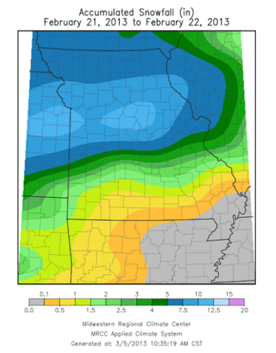
Figure 1
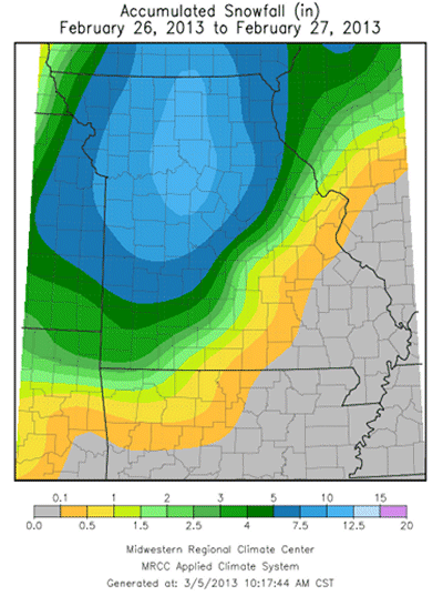
Figure 2
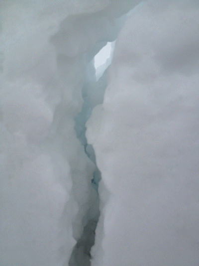
Figure 3 - "Blue snow" in Columbia, Missouri
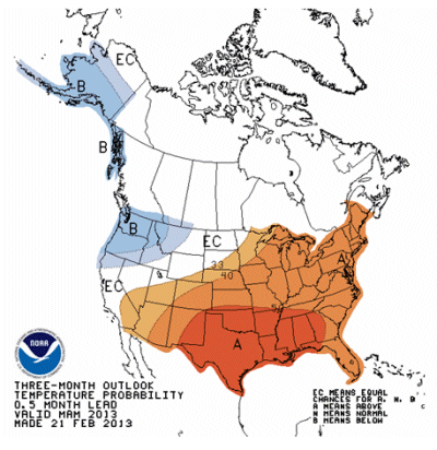
Figure 4 - 2013 Spring Temperature Outlook, Mar-Apr-May
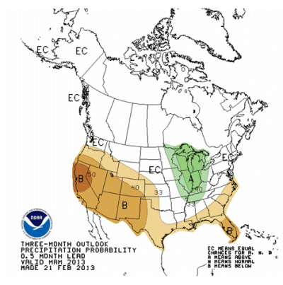
Figure 5 - 2013 Spring Precipitation Outlook, Mar-Apr-May
Figure 6
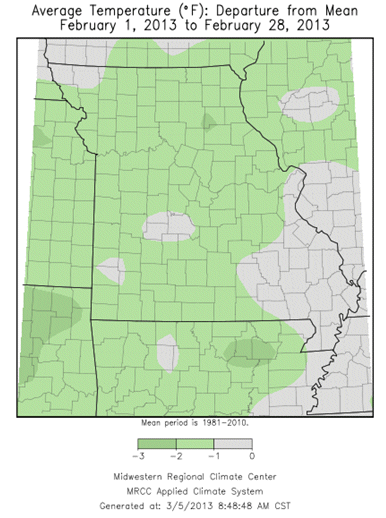
Figure 7
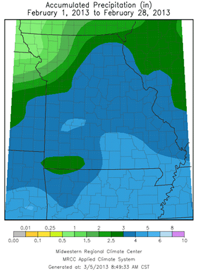
Figure 8
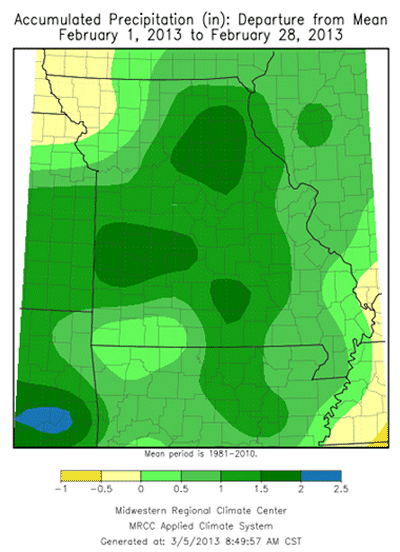
Figure 9