
May 2021 Weather and Its Impacts on Missouri
Pat Guinan
State Climatologist
University of Missouri Extension
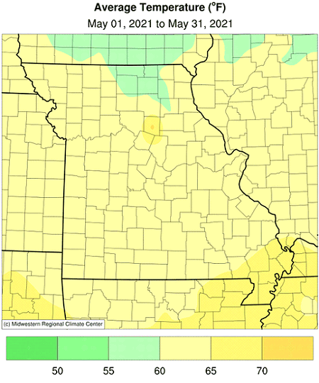
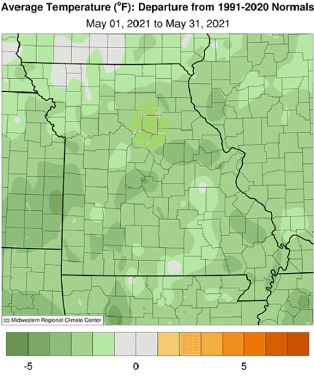
Cool temperatures were the rule in Missouri during May, especially with maximum daily temperatures remaining below average, Figure 1. Preliminary data indicate the statewide average temperature was 62.0°F, or 2.2° below the long-term average. The cool conditions were similar to May weather the previous year, Figure 2. It was the second consecutive cool month and third below average month for the year, Figure 3.
Preliminary data for the spring season (Mar-Apr-May) indicate an average temperature of 55.4°F, or 1.2° above the long-term average. Unusually mild March temperatures offset the negative departures in April and May. Over the past 24 years, there have been only five cooler than average springs, Figure 4.
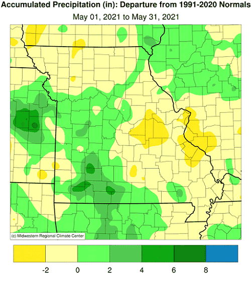
May precipitation was variable across Missouri but averaged above normal for the state. Preliminary data indicate a statewide average total of 5.30 inches, or 0.64 inches above the long-term average. The wet conditions mimic the trend over the past 32 years. Since 1990, 22 Mays, or 69% of them, have been wetter than average, Figure 5. Four out the five wettest Mays on record have occurred since 1990. Wetter than average months have been dominant since October of last year, where six out of the past eight months have been wetter than average, Figure 6.
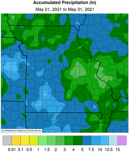
May precipitation varied across the Show Me State, ranging between 2-3 inches in some east central counties to more than 10-inches in parts of west central and southwestern Missouri, Figure 7. Some of the highest and lowest monthly totals are listed in Table 1.
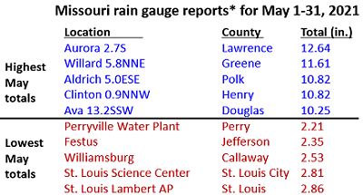
*Rain gauges are from the NWS Cooperative network or CoCoRaHS
Table 1.
There were several days during the month with cloudy, showery weather, especially during the latter half of May. Several locations experienced measurable rainfall and overcast conditions for more than half the May days. Using solar radiation records for Columbia, MO, it was the lowest solar May since 1995, Figure 8.
Preliminary precipitation data for the spring season indicate a statewide average total of 14.82" or 2.98 inches above the long-term average. It was the third consecutive wetter than average spring for the state, Figure 9. Precipitation for 20 out of the past 32 springs (63%) has been above average.
According to the Missouri Agricultural Statistics Service, as of May 30, 2021, 92% of the corn and 49% of the soybean crop had been planted; the 5-year average is 91% and 53%, respectively. The cool, cloudy weather generally benefited pastures with 71% of them reported to be in good condition and 6% excellent. Hay supplies and other roughages were listed at 85% adequate and 4% surplus. Stock water supplies were reported mostly adequate at 87% and 13% surplus. Topsoil moisture supplies were mostly adequate (57%) to surplus (42%) statewide. Subsoil moisture supplies were mostly adequate (74%) to surplus (25%).
Jump to:
- Figure 1
- Figure 2
- Figure 3
- Figure 4
- Figure 5
- Figure 6
- Figure 7
- Figure 8
- Figure 9
- Figure 10
- Figure 11
- Figure 12
- Figure 13
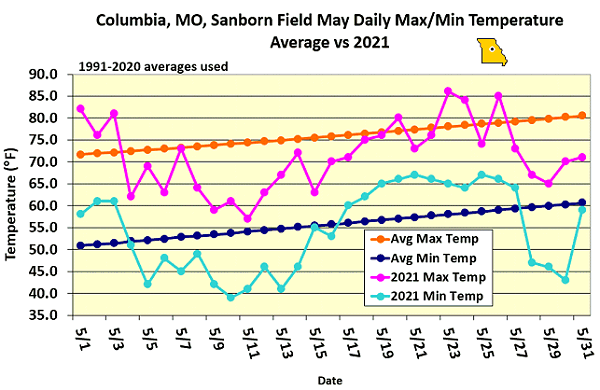
Figure 1.
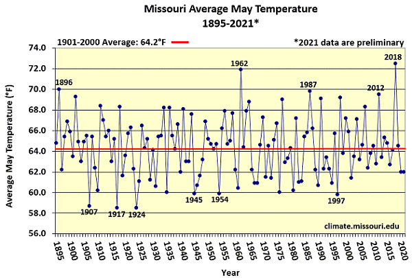
Figure 2.
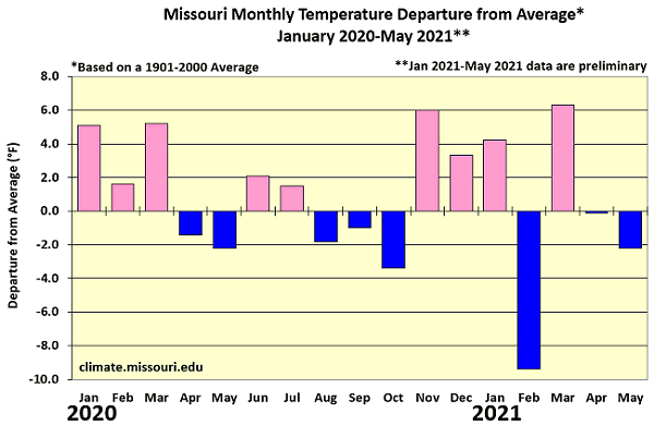
Figure 3.
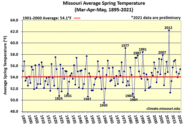
Figure 4.
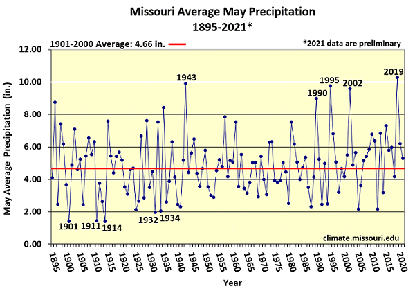
Figure 5.
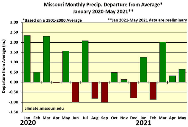
Figure 6.
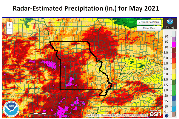
Figure 7.
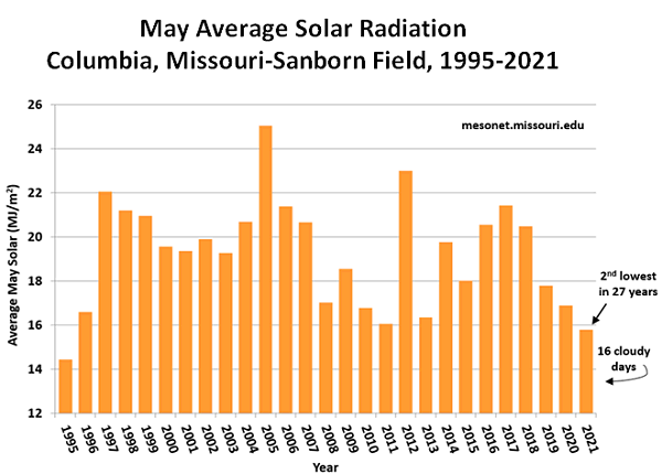
Figure 8.
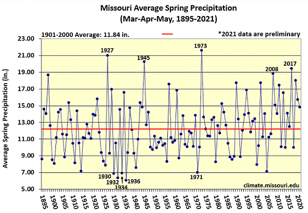
Figure 9.
Source: Pat Guinan, 573-882-5908