
May 2017 Weather and Its Impacts on Missouri
Pat Guinan
State Climatologist
Commercial Agriculture/University of Missouri Extension
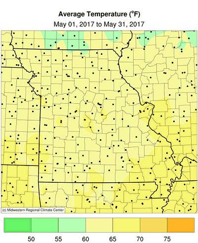
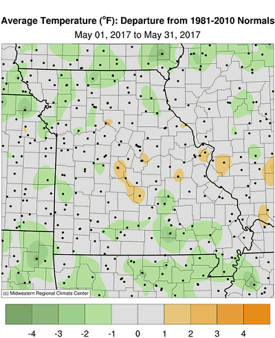
Alternating cool and warm weather periods occurred in May with coldest temperatures during the first week of May, warmest conditions during mid-month and near average temperatures toward the end of the month, Figure 1. Preliminary data indicate the average statewide temperature for May was 64.0°F, or 0.3 degrees below the long-term average. It was only the third time in the past 17 months where cooler than average temperatures occurred, Figure 2. With the exception of 2012, May temperatures have trended near average to seasonably cool over the past decade in Missouri, Figure 3.
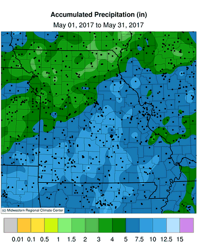
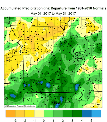
Preliminary precipitation data indicated a statewide average May total of 6.03 inches, or 1.26 inches above the long-term average. The wetter than average conditions followed the historic trend of wet Mays over the past several years, Figure 4. There have been only four years since 2001 where May precipitation averaged below normal. It was also the third consecutive wetter than average month for the year, Figure 5, wettest spring (Mar-Apr-May) in more than 40 years, and 4th wettest spring on record for the Show Me State, Figure 6.
Rainfall was variable across the state with heaviest totals observed across the southeastern half of Missouri, where 5-8 inches were common. Some locations across southern Missouri reported more than 10-inches of rain for the month, Table 1. Drier, below normal rainfall occurred across much of northern Missouri where some locations observed less than 2-inches for the month, less than 50% their monthly average, Table 2.
The Springfield National Weather Service forecast office reported their 2nd wettest spring on record, 24.24 inches, and the wettest spring since 1945 when 25.16 inches was observed. West Plains Missouri (Howell county) reported its wettest spring on record this year with 30.78 inches.
| Highest May 2017 Rainfall (NWS Coop and CoCoRaHS reports) | ||
| Location* | County | May 1-31 Rainfall (in.) |
| Ava 0.8NNW | Douglas | 12.15 |
| Poplar Bluff | Butler | 12.15 |
| Springfield 4.9SE | Greene | 11.55 |
| Neosho 3.9WNW | Newton | 11.33 |
| Lake Wappapello SP | Wayne | 11.24 |
| Table 1. | ||
| Lowest May 2017 Rainfall (NWS Coop and CoCoRaHS reports) | ||
| Location* | County | May 1-31 Rainfall (in.) |
| Maysville 0.4SSE | DeKalb | 1.19 |
| Kirksville Regional AP | Adair | 1.79 |
| Kansas City Downton AP | Clay | 1.91 |
| Kahoka 0.6S | Clark | 2.40 |
| Brookfield 3.7NNE | Linn | 2.62 |
| Table 2. | ||
Overall the wet spring conditions eliminated statewide growing season dryness concerns following the driest Oct-Feb period in more than 50 years, Figure 7. According to the Missouri Agricultural Statistics Service, as of May 28, 99% of Missouri was reporting adequate to surplus topsoil moisture conditions, and 98% of the state reported adequate to surplus subsoil moisture conditions. Statewide pasture conditions were reported 75% good to excellent. Nearly all the corn was planted by the end of the month (97%) and 53% of the corn was reported in good to excellent condition. Just over half of the soybean had been planted by the end of May (54%).
At the end of May, Missouri was experiencing no dryness according to the U.S. Drought Monitor map, Figure 8, but conditions can deteriorate quickly as summer approaches. Evaporative demand is highest during the summer months (Jun-Jul-Aug) and can exceed two feet during hot, dry weather. Vegetation with high clay content soil, Figure 9, is especially vulnerable to vegetative stress when growing season dry periods emerge.
When it comes to assessing drought for your area, all Missouri residents have the opportunity to submit drought impact reports to the National Drought Mitigation Center. A website called the Drought Impact Reporter, http://droughtreporter.unl.edu/, is a resource for submitting these reports. In order to contribute impact reports, and provide local expertise to authors of the Drought Monitor map, participants are encouraged to use the Drought Impact Reporter. Drought impact statements are seen by the Drought Monitor author, as well as the general public, and become archived documentation for future authors to refer to. More participation and input from local Missourians will establish a consensus of opinions among folks and hopefully provide a more accurate portrayal of drought in the Show Me State.
Figure 10 is the latest summer temperature and precipitation outlook (Jun-Jul-Aug) issued by the Climate Prediction Center. The outlook indicates a slightly enhanced likelihood of above normal temperatures over southeastern Missouri and equal chances of above, below and near normal temperatures across the rest of the state. There is a slightly enhanced likelihood of above normal rainfall forecasted for far western Missouri, and equal chances for above, below and near normal precipitation for the rest of the state.
Jump to:
- Figure 1
- Figure 2
- Figure 3
- Figure 4
- Figure 5
- Figure 6
- Figure 7
- Figure 8
- Figure 9
- Figure 10
- Figure 11
- Figure 12
- Figure 13
- Figure 14
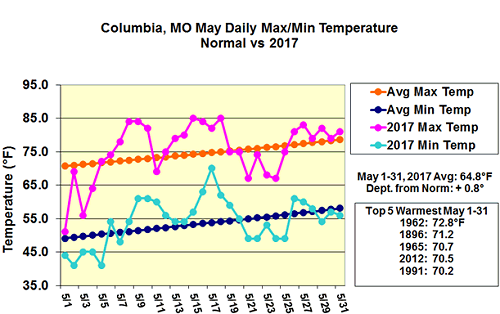
Figure 1.
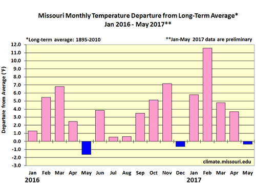
Figure 2.
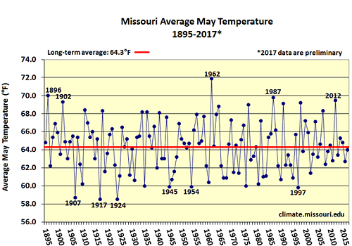
Figure 3.
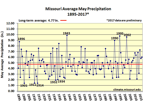
Figure 4.
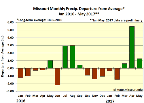
Figure 5.
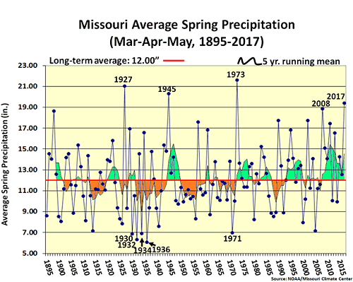
Figure 6.
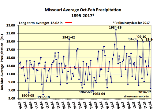
Figure 7.
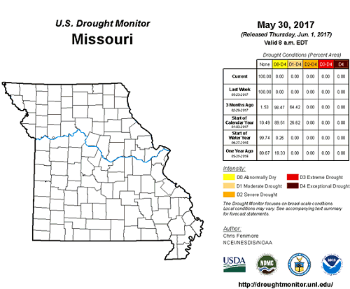
Figure 8.
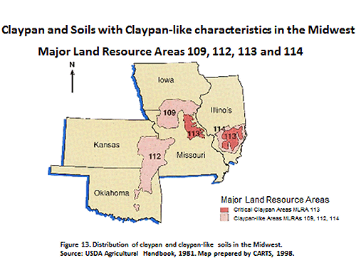
Figure 9.
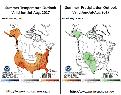
Figure 10.
Source: Pat Guinan, 573-882-5908