
May 2016 Weather and Its Impacts on Missouri
Pat Guinan
State Climatologist
University of Missouri Extension
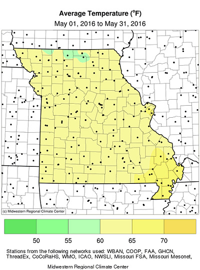
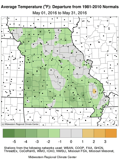
For the first time in eight months the monthly temperature averaged below normal in the Show Me state, Figure 1. Preliminary data indicate the average statewide temperature for May was 62.6°F, or 1.7 degrees below the long-term average. It was the first time since 2013 when May temperatures were cooler than average, Figure 2. From the onset, temperatures were variable during the month with alternating cool and mild periods, Figure 3.
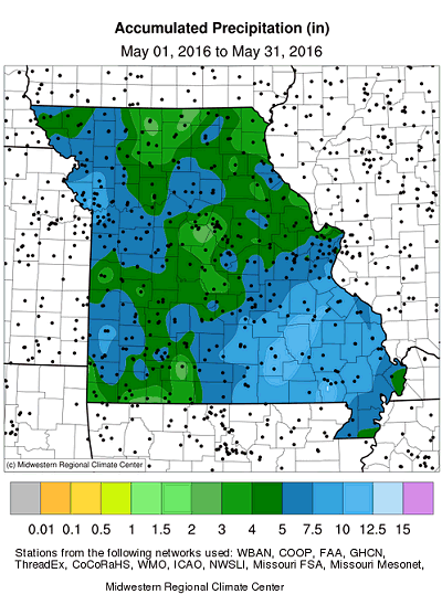
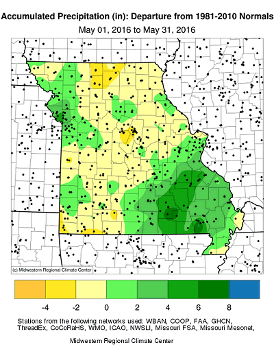
Preliminary precipitation data indicated a statewide average May total of 5.90 inches, or a little more than one-inch above the long-term average. The wetter than average conditions followed the historic trend of wet Mays over the past several years, Figure 4, and it was the first wetter than normal month for the year, Figure 5.
Rainfall was variable across the state with heaviest totals reported across southeastern and northwestern sections, where 5-8 inches were common. Another area of higher rainfall, 5-7 inches, was located in southwestern Missouri, from Nevada to Joplin. Below average rainfall, with amounts ranging from 3-5 inches, were typical over north central, northeast, central and portions of southwestern Missouri. Some of the highest and lowest monthly totals are listed in Table 1.
| Highest May 2016 Rainfall | ||
| Location | County | May 1-31 Rainfall (in.) |
| 1. Van Buren | Carter | 11.50 |
| 2. Eminence | Shannon | 11.28 |
| 3. Ellington | Reynolds | 11.07 |
| 4. Farmington | St. Francois | 10.84 |
| 5. Alton | Ripley | 10.49 |
| Lowest May 2016 Rainfall | ||
| Location | County | May 1-31 Rainfall (in.) |
| 1. Milan | Sullivan | 3.10 |
| 2. Columbia | Boone | 3.01 |
| 3. Boonville | Cooper | 2.90 |
| 4. Monticello | Lewis | 2.67 |
| 5. Butler | Bates | 2.63 |
| Table 1. | ||
Even though statewide rainfall was above normal for the month, a significant portion of Missouri has accumulated notable water deficits for the year, Figure 6. Parts of northeastern, central and southwestern Missouri are running 4-6 inches below normal since January 1, and, with the onset of summer, a wetter pattern is necessary in order to avoid water stress. According to the Missouri Agricultural Statistics Service, as of May 29, 48% of southwestern Missouri was reporting topsoil moisture in short to very short condition. Springfield, MO reported their driest January through May since 2000 with 11.25 inches (-6.78 inches), and Columbia, MO observed its driest January-May period since 1992, with 10.13 inches (-6.42"), Figure 7.
The Evaporative Demand Drought Index (EDDI) indicates abnormally dry to moderate drought conditions impacting a significant portion of Missouri as of June 1, 2016, Figure 8. The EDDI is a good precursor for detecting emerging dryness for a region, including flash drought, and is relevant to Missouri agriculture during the growing season. For more information on EDDI, please visit the following link: http://wwa.colorado.edu/publications/reports/EDDI_2-pager.pdf.
A direct link for EDDI maps of Missouri can be accessed at: ftp://ftp.cdc.noaa.gov/Public/mhobbins/EDDI/MO/.
As of the end of May, Missouri was not officially experiencing drought according to the Drought Monitor map, Figure 9, but conditions can deteriorate quickly as summer approaches. Evaporative demand is highest during the summer months and can exceed two feet, Figure 10. Vegetation with high clay content soil, Figure 11, is especially vulnerable to vegetative stress when dry periods first emerge.
When it comes to assessing drought for your area, all Missouri residents have the opportunity to submit drought impact reports to the National Drought Mitigation Center. A website called the Drought Impact Reporter, http://droughtreporter.unl.edu/, is a resource for submitting these reports. In order to contribute impact reports, and provide local expertise to authors of the Drought Monitor map, participants are encouraged to use the Drought Impact Reporter. Drought impact statements are seen by the Drought Monitor author, as well as the general public, and become archived documentation for future authors to refer to. More participation and input from local Missourians will establish a consensus of opinions among folks and hopefully provide a more accurate portrayal of drought in the Show Me State.
Figure 12 is the latest summer temperature and precipitation outlook (Jun-Jul-Aug) issued by the Climate Prediction Center. The outlook indicates a slightly enhanced likelihood of above normal temperatures over much of Missouri, with the exception of far western sections where equal chances of above, below and near normal temperatures are anticipated. There is a slightly enhanced likelihood of above normal rainfall forecasted for the western half of Missouri, and equal chances for above, below and near normal precipitation for the rest of the state.
Jump to:
- Figure 1
- Figure 2
- Figure 3
- Figure 4
- Figure 5
- Figure 6
- Figure 7
- Figure 8
- Figure 9
- Figure 10
- Figure 11
- Figure 12
- Figure 13
- Figure 14
- Figure 15
- Figure 16
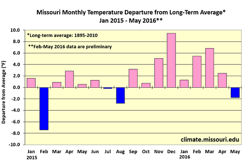
Figure 1.
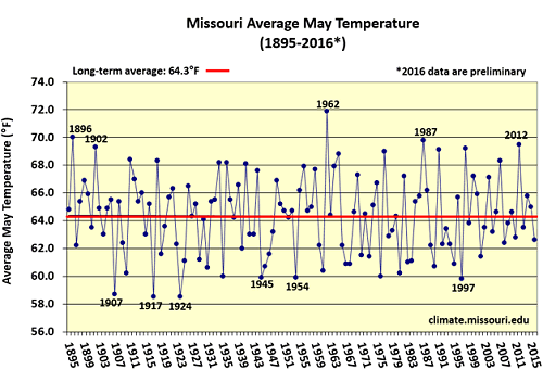
Figure 2.
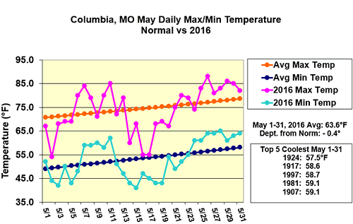
Figure 3.
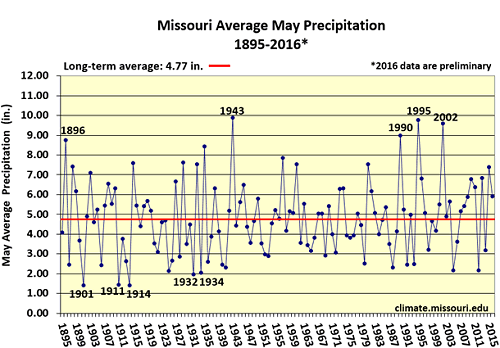
Figure 4.
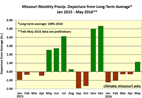
Figure 5.
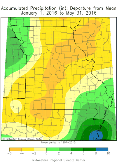
Figure 6.
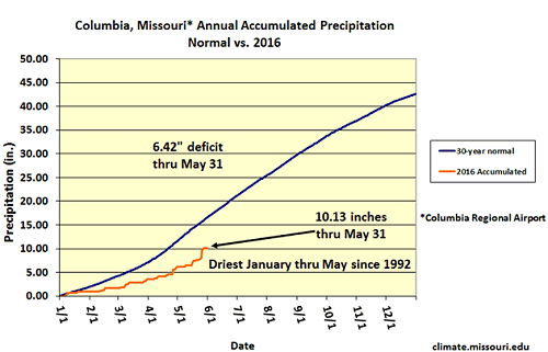
Figure 7.
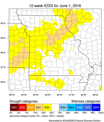
Figure 8.
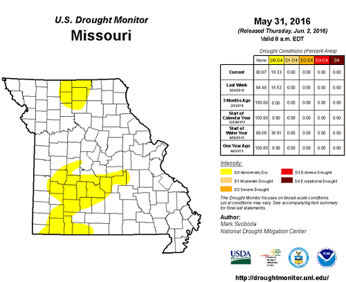
Figure 9.
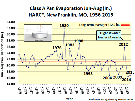
Figure 10.
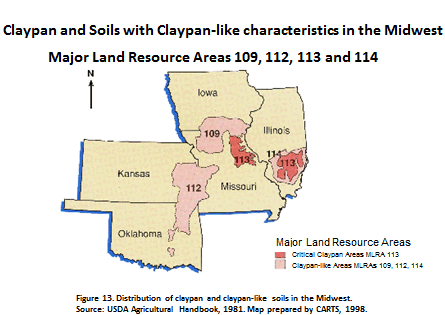
Figure 11.
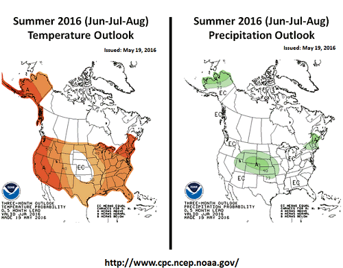
Figure 12.
Source: Pat Guinan, 573-882-5908