
Driest May-June period in Missouri since 1988
Pat Guinan
State Climatologist
Commercial Agriculture/University of Missouri Extension
June 27, 2012
Very dry conditions were impacting all of Missouri by the end of June, with nearly 90% of the state experiencing various levels of drought, ranging from moderate to extreme drought according to the U.S. Drought Monitor map. The dry spell, however, has not been exclusively a June phenomenon. Dryness first began to emerge in April over southeastern and west central sections of Missouri, where a few locations in the Bootheel reported less than 1-inch for the month.
As May progressed, the dryness spread northward to encompass much of the state by the end of the month. May precipitation was nearly 3 inches below normal statewide, with preliminary rainfall data indicating a statewide average monthly total of 2.20 inches, and guaranteeing a position in the "Top 10" driest Mays for Missouri.
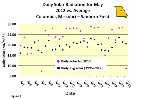
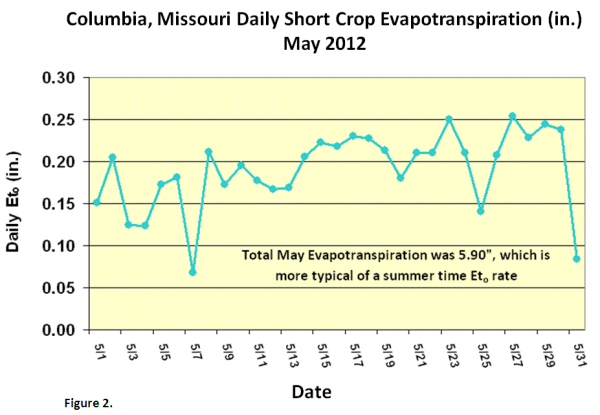
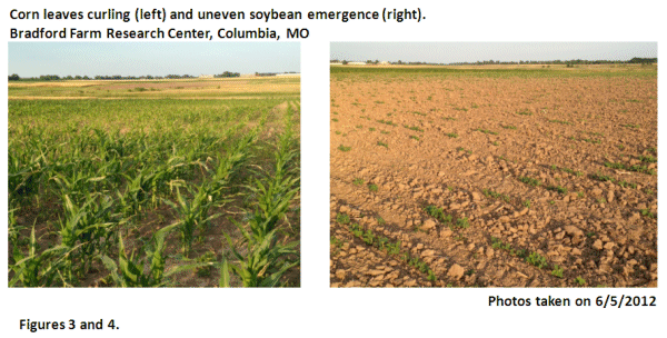
Numerous sunny days during May (Figure 1), coupled with above normal temperatures and below normal relative humidity led to unusually high moisture loss from soils, vegetation and water surfaces for the month — a process known as evapotranspiration, or ETo (Figure 2). These conditions, in combination with lack of rainfall, resulted in a flash drought across much of the state as agricultural and horticultural impacts rapidly emerged. Reports of deteriorating pastures, declining soil moisture reserves, limited stock water supplies, and crop stress (Figures 3 and 4) increased as May progressed. Homeowners’ lawns began turning brown and irrigation was going at a summer-like pace in many locations. Several automated weather stations across the state estimated short crop ETo rates of 0.20"/day, and totals approached 6 inches for the month, more typical of summer.
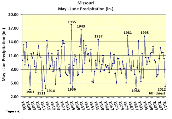
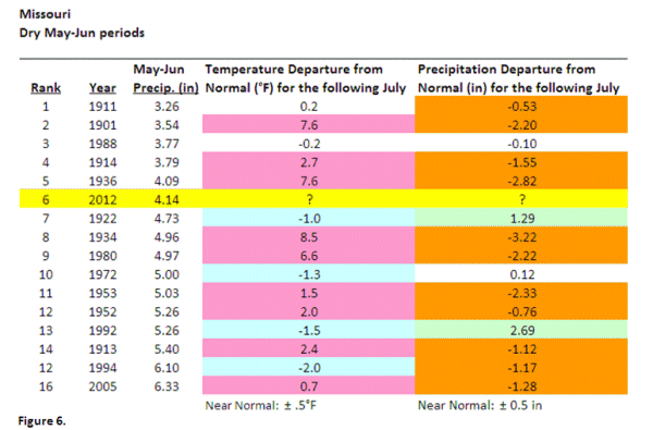
Drought conditions persisted in June and preliminary data indicate a statewide average precipitation total of less than 2-inches, likely ranking in the "Top 10" driest Junes on record for Missouri (Figure 5). The combined May-June average rainfall for the state was just over 4-inches, ranking it the 6th driest May-June period on record and the driest since 1988. Highly unusual triple digit temperatures were also experienced throughout the state toward the end of the June, which was the earliest since 1988.
According to the Missouri Ag Statistics Service Field Office, 87% and 85% of the topsoil and subsoil moisture supplies, respectively, were in short to very short condition toward the end of June. Corn and soybean conditions were 26% and 35% poor to very poor, respectively. Pasture condition had declined to 58% poor to very poor. Hay and stock water supplies were also declining.
Historically, a dry May-June period does not bode well for Missouri. Figure 6 shows the Top 16 driest May-June periods on record for the state, and what happened the following July in regard to temperature and precipitation departures. Climatology indicates 60%, 27% and 13% were hotter, cooler, and near normal, respectively and 73%, 13%, and 13% were drier, wetter, and near normal, respectively.
 |
 |
 |
 |
 |
Questions? Comments?
Please e-mail Dr. Patrick Guinan , Phone: 573-882-5908
Missouri State Climatologist
School of Natural Resources
102 Anheuser-Busch Natural Resources Building
Columbia, MO 65211