May 2011 Weather and Its Impacts on Missouri
Pat Guinan
State Climatologist
Commercial Agriculture/University of Missouri Extension
Preliminary data from Missouri indicated slightly below normal temperatures and above normal precipitation for the month of May, but much of the month was dominated by highly contrasting air masses over the region, leading to periods of much warmer than normal and much cooler than normal weather. The month was also accompanied by tragedy when a historic and deadly tornado devastated the community of Joplin.
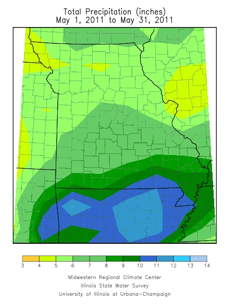
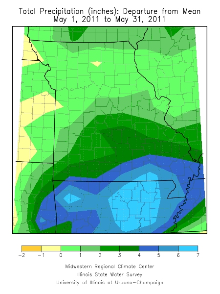
Numerous rain events throughout the month led to above normal precipitation for most locations. Preliminary numbers indicate the statewide average total for the month was just over 6.5 inches, or about 2-inches above normal. Generally, 5-7 inches fell over northern and central sections whereas 7-9 inches were common across southern Missouri. A few southern border counties and the Bootheel reported more than 10 inches for the month.
The highest rainfall total came from extreme southwestern Missouri, in McDonald County, where the community of Noel reported 14.55 inches. Alternatively, the community of Rock Port, located in far northwestern Missouri, Atchison County, received only 2.39 inches.
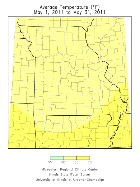
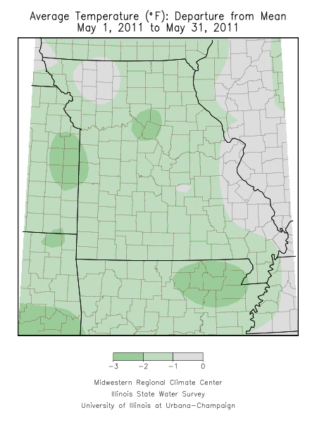
Overall, May temperatures averaged about 1 degree below normal for the state but high variability during the month masked some unusually warm and cool periods.
The first week of May was unseasonably cool with temperatures averaging nearly 10 degrees below normal. With the exception of the Bootheel, statewide minimum temperatures during the mornings of May 3-4 dipped into the lower and middle 30s with many reports of frost.
A warm and humid air mass enveloped the state during the second week of May and brought summer-like heat to the area. Many locations witnessed record or near record heat from the 8th to the 11th when temperatures climbed into the upper 80s and lower to middle 90s. Springfield and St. Joseph broke maximum temperature records on the 9th when the mercury climbed to 89°F and 93°F, respectively. On May 11, St. Louis tied their previous record of 91°F set in 1914.
The roller coaster temperature ride continued into the third week of May when cool Canadian high pressure encompassed the region. High temperatures struggled to climb out of the 50's and 60's for much of the week and many locations across northern and central Missouri, and portions of the Ozarks, experienced low temperatures in the mid and upper 30s on the 16th and 17th. Numerous record low temperatures were recorded on the 16th and 17th including, on the 16th, St Joseph, 35°F, and Joplin, 42°F. Minimum temperature records on the 17th included St. Joseph, 36°, Springfield, 37°F, Rolla, 39°F, and Joplin, 40°F.
The last week of May began cool and ended warm, and it was these battle of air masses during the month, in combination with other atmospheric parameters, that led to a tragic and historic day in southwestern Missouri.
During the late afternoon of Sunday, May 22, all the ingredients fell into place for a deadly tornado that left an indelible mark on Joplin, MO, a community of 50,000 people.
According to a survey conducted by the National Weather Service office in Springfield, Missouri, the multiple vortex tornado touched down just outside the western city limits of Joplin at 5:41 p.m. and rapidly intensified to an EF-5 tornado (>200 mph) within a few miles of initial touchdown. As the tornado tore through the city, at less than 10 miles per hour, it left a 0.75 to 1-mile wide path of destruction. The tornado weakened to EF-2 intensity near the eastern city limits, turned southeast and crossed Interstate 44, eventually lifting 3 miles northwest of Diamond, MO. The total path length was 13.8 miles and the destruction was incomprehensible.
Nearly 7,000 homes were destroyed in addition to many businesses, churches, schools, a nursing home, a bank and one of two major hospitals in the area. Estimates indicate that nearly 30% of Joplin was damaged or destroyed. According to Bill Davis, Springfield NWS chief meteorologist, "the six-mile track within the city of Joplin was by far the most intense and devastating".
The tornado claimed 160 lives (updated 8/17/2011) and injured more than 1,150 people and ranks as the deadliest single tornado on record for the state of Missouri. The state's second deadliest single tornado, a category F4, killed 137 people and injured 800 in St. Louis on May 27, 1896. For the United States, the Joplin tornado ranks as the 8th deadliest on record and the deadliest since 1947.
Additionally, a police officer who volunteered to assist in the disaster recovery was struck by lightning in Joplin the day after the tornado and died from his injuries.