Missouri Spring 2010 Weather Summary
Pat Guinan
State Climatologist
Commercial Agriculture/University of Missouri Extension
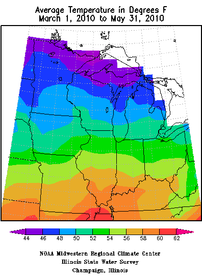
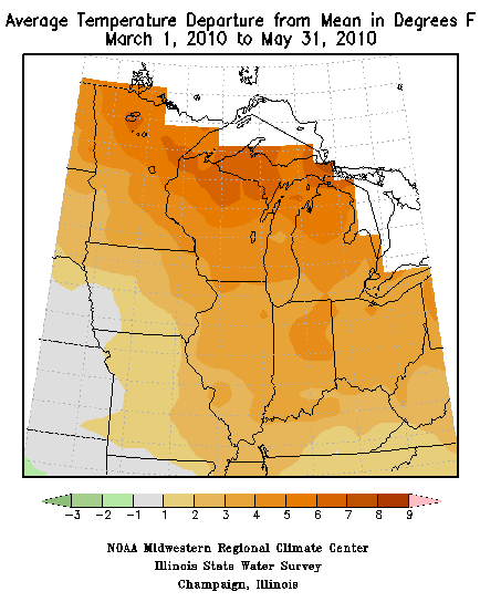
Preliminary numbers are indicating the spring of 2010 will go down as a seasonably wet and mild one for Missouri. March, April and May were all warmer than normal averaging 1.2, 5.7 and 0.6 degrees Fahrenheit above normal, respectively. Three weeks of mild weather during April made it the fifth warmest April on record for Missouri, and three consecutive months with above normal temperatures translated to the 15th warmest spring out of the past 116 years. The mild spring followed the seasonal trend over the past decade with 7 out the past 10 springs being warmer than normal. Over the past 10 years, only 2002 and 2008 have been cooler than normal while the spring of 2005 was right at normal.
Generally, the last spring frost this year occurred 1 to 2 weeks earlier than normal with most northern locations experiencing their last ≤32°F on 4/8 or 4/9 and central and southern sections during the last week of March. Some low-lying areas along the Ozark Plateau witnessed freezing temperatures as late as mid-April whereas the Bootheel counties saw their last frost during the first week of March, nearly 4 weeks earlier than normal.
A weather pattern shift in May led to a more seasonable to below-normal temperature regime during the first 3 weeks of the month with several days of cool, cloudy and damp conditions occurring during mid-month. The pattern abruptly shifted to much warmer and drier weather during the last 10 days of May with many locations reporting daily maximum temperatures well into the 80s and lower 90s through the end of the month. Some daily record high temperatures were also established during this time.
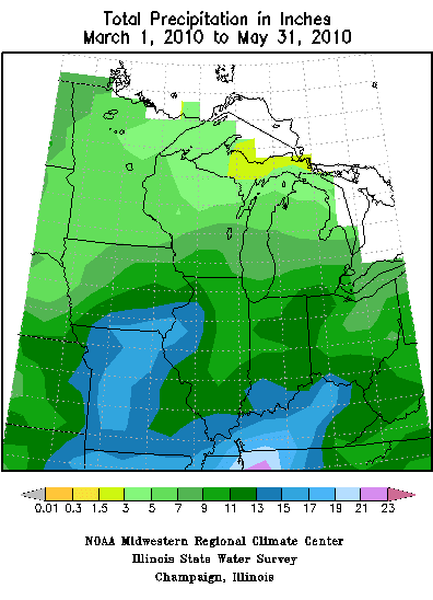
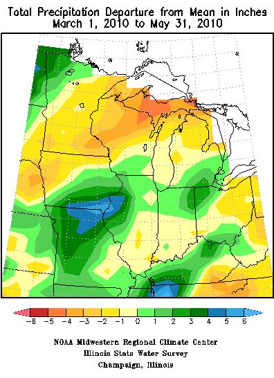
Springtime precipitation was variable across the state from month to month; but overall, statewide average precipitation for March and April totaled 3.21 and 3.50 inches, respectively, and was slightly below normal for both months. May rainfall was heavier and averaged 6.84 inches, or more than 2-inches above normal. The combined springtime average was 13.55 inches, which is 1.43 inches above the seasonal norm.
Regionally, precipitation extremes for March ranged from 5-6 inches across far southeastern sections to 1.5-2.0 inches in some far northeastern counties. April extremes varied from 5.5-8.5 inches over central and northeastern sections to less than 3 inches in parts of southwestern Missouri. May high rainfall extremes ranged from 8-11 inches across southwestern sections and a few northern Missouri counties, especially along the Iowa border. Alternatively, the lowest May rainfall totals ranged between 3-5 inches over portions of east central and southeastern Missouri.
The latest summer outlook as issued by the Climate Prediction Center for the months of June, July and August calls for below normal temperatures across all of Missouri with the exception of the Bootheel where equal chances of above, below and near normal temperatures are given. Equal chances for above, below and near normal rainfall are forecasted for all of the Show-Me State.