June 2020 Weather and Its Impacts on Missouri
Pat Guinan
State Climatologist
University of Missouri Extension
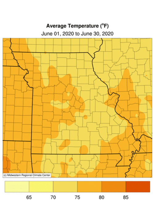
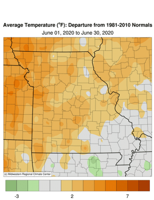
Above average June temperatures were dominant for Missouri with preliminary data indicating a statewide average monthly temperature of 72.4�F, or 2.0 degrees above the long-term average. The above average temperatures followed the warm trend over the past several years, where only one June since 2005 has been cooler than average, Figure 1. It was also the first warmer than average month since March, Figure 2.
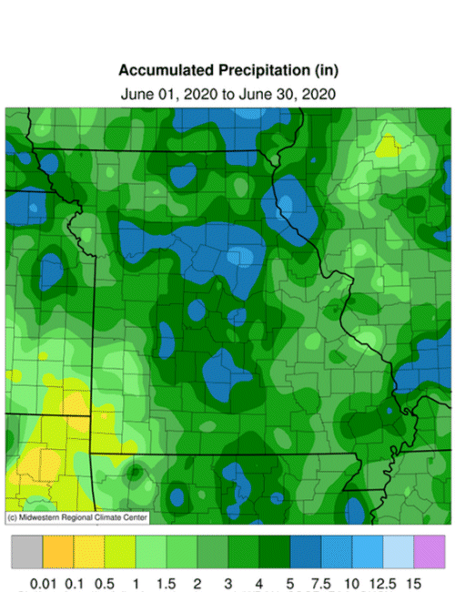
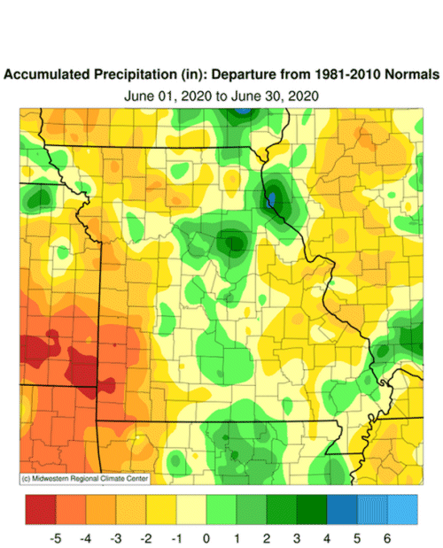
June precipitation was below average statewide, but highly variable across Missouri, ranging from over 9-inches in far northeastern sections to less than 0.50 inches in the far southwestern corner of the state, Figure 3. The statewide average rainfall total was 3.58 inches, a little more than 1-inch below the long-term average, Figure 4. It was the first month this year with below average precipitation, Figure 5. Some of the heaviest and lightest monthly totals are listed in Tables 1 and 2.
| Highest June 2020 Rainfall (in) - NWS Coop and CoCoRaHS reports | ||
| Location | County |
Precip (in) |
| Hannibal | Marion | 9.17 |
| Westphalia 10.3SW | Osage | 8.30 |
| Centralia 1.5N | Boone | 8.16 |
| Arbela 2.7ENE | Scotland | 7.96 |
| Salisbury | Chariton | 7.90 |
| Table 1. | ||
| Lowest June 2020 Rainfall (in) - NWS Coop and CoCoRaHS reports | ||
| Location | County |
Precip (in) |
| Seneca | Newton | 0.37 |
| Anderson 4.2W | McDonald | 0.48 |
| Carthage 3.8SW | Jasper | 0.59 |
| Cassville 4.8SSE | Barry | 0.70 |
| Lockwood | Dade | 0.97 |
| Table 2. | ||
An unusual event impacted Missouri on Jun 8-9 when the remnants of an early season Tropical Storm named Cristobal spiraled northward through the center of Missouri and dropped significant rainfall, ranging from 1-4 inches, Figure 6. It was unusual not only for the time of year but also for the track it made from Louisiana to Missouri, north-northeastward into Iowa, Wisconsin and Michigan, Figure 7.
Abnormally dry conditions began to emerge as June progressed and was impacting far western sections of the state, especially around the Kansas City area southward to the Arkansas border, according to the U.S. Drought Monitor at the end of the month, Figure 8. A few counties south of St. Louis were also abnormally dry and moderate drought crept into portions of Jasper and Newton Counties, in far southwestern Missouri.
According to the Missouri Agricultural Statistics Service, for the week ending June 28, 7% of the corn was silking compared to a 5-year average of 17%. Soybean was 94% planted, compared to a 5-year average of 86%. Topsoil moisture supplies were rated 77% adequate to surplus and subsoil moisture was rated at 87% adequate to surplus. Corn was rated mostly good to excellent at 68% and soybean was reported at 63% good to excellent. Pasture conditions were mostly good to excellent at 66%. The majority of hay supplies and other roughages were adequate at 97%. Stock water supplies were reported to be in adequate (94%) or surplus (4%) condition.
Jump to:
- Figure 1
- Figure 2
- Figure 3
- Figure 4
- Figure 5
- Figure 6
- Figure 7
- Figure 8
- Figure 9
- Figure 10
- Figure 11
- Figure 12
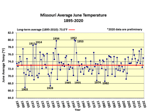
Figure 1.
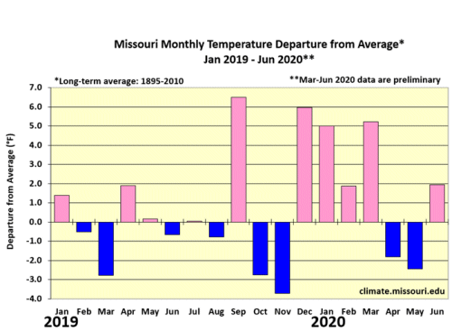
Figure 2.
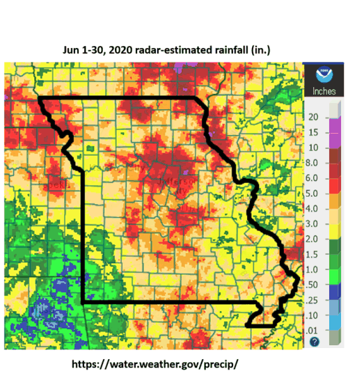
Figure 3.
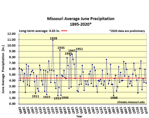
Figure 4.
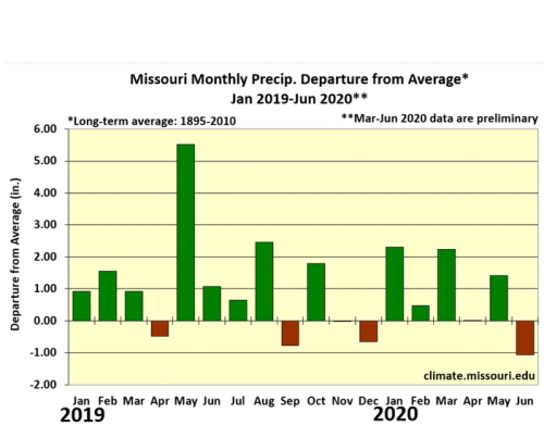
Figure 5.
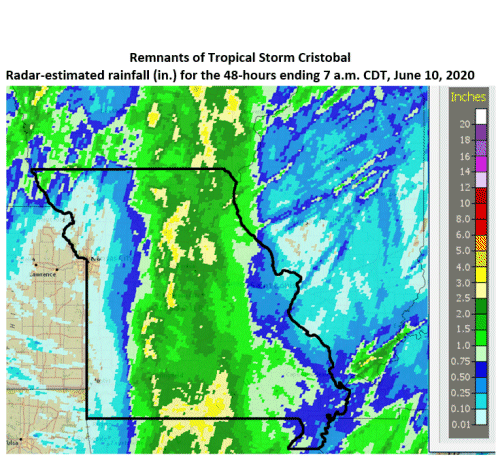
Figure 6.
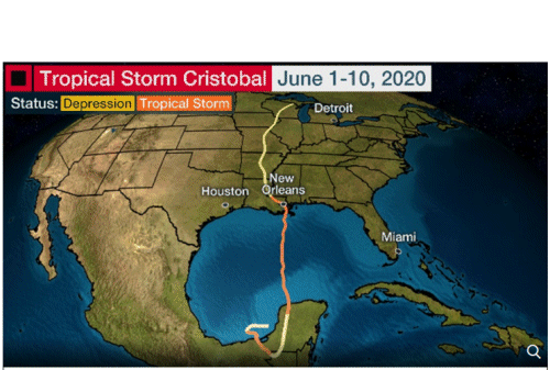
Figure 7. Data provided by NOAA, image from the Weather Channel.
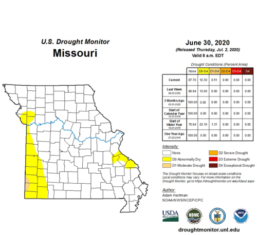
Figure 8.
Source: Pat Guinan, 573-882-5908