
Who'll Report the Rain?
Volunteer-driven CoCoRaHS includes daily precipitation reports
Kyle Spradley
Strat Comm Associate
MU College of Agriculture, Food and Natural Resources
July 30, 2014
Summers in the Midwest are often about the haves and have-nots. Some are getting the rain, while others watch as storm after storm passes over their cropland that is pining for a drop.
Many have insurance on their crops to help aid in years of droughts or floods. But with localized storms it can sometimes be hard for insurance agencies to access what each farmer is dealing with, even on the county level.
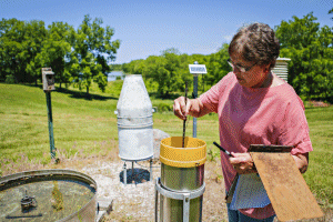
Nancy Bishop, senior research/lab technician, checks rain and other weather gauges at the Horticulture and Agroforestry Research Center in New Franklin. Each day Nancy uploads the recorded data to weather reporting sites and the CoCoRaHS precipiation monitoring network. "It only takes a couple of minutes and simple to do," said Nancy. "But this is extremely important data to have for our researchers and farmers across the country."
A valuable tool in monitoring precipitation is CoCoRaHS. The free online database is the acronym for the Community Collaborative Rain, Hail and Snow Network. Daily reports of precipitation are collected through a grassroots effort of volunteers that measure and submit to the website at www.cocorahs.org. The data is then mapped out to allow users quick and easy access to rainfall amounts in their area. Archives also are available to search previous weather events.
"CoCoRaHS started at Colorado State University in 1998 and now has expanded to all 50 states and even parts of Canada," said Pat Guinan, Missouri state extension climatologist. "Missouri was the 13th state to join and we now have more than 300 locations that report on a regular basis in all 114 counties. It's been a phenomenal resource for our state!"
As each day's precipitation is inputted by users, climatologists like Guinan use the near real-time data to monitor conditions around the state, such as drought and flood. The National Drought Mitigation Center, and other partner agencies, use CoCoRaHS reports with additional products, data and information to create weekly drought assessment maps. Illustrated on the maps is the intensity of the drought, but also provides predictions on what area is coming out of a drought and what the region should expect in the future.
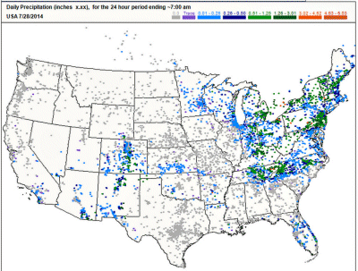
A national view of CoCoRaHS data. Image courtesy of CoCoRaHS
Climatologists and weather forecasters also use the data from CoCoRaHS for flood predictions to estimate how rain and snowfall affect river levels. Flash flood alerts also can be based off of the precipitation inputs to help saves lives and protect people's property.
"Things can change pretty rapidly during these summer storms," added Guinan. "I have seen a location get five inches of rain and just a few miles down the road only report a tenth of an inch. So having this hyper-localized data can really help us know what is going on out there."
The data also can be used for climate predictions. Once researchers have years of precipitation records they can look at how the climate is changing and determine trends and perhaps future patterns.
Volunteer participation is simple to be a part of a project that has major emphasis in climatology studies.
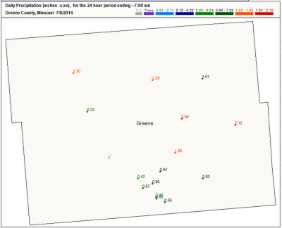
A screen shot from the CoCoRaHS website. This map shows precipitation across Missouri's Greene County on July 8, 2014. Even across the county, varied rain events can be seen. Image courtesy of CoCoRaHS
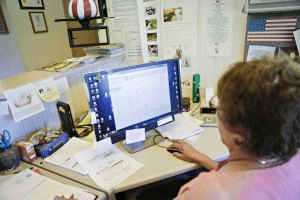
"It only takes me a few minutes every day to submit my reports," said Nancy Bishop, research technician at the Horticulture and Agroforestry Research Center (HARC). "Each morning I walk out to the rain gauges and report what I see. After a few inputs on the website the data is available for everyone to see and use. Most days it's as simple as if it's even raining out."
Bishop has been reporting weather at HARC for nearly 25 years. The Agricultural Resource Center in New Franklin is one of numerous centers operated by the MU College of Agriculture, Food and Natural Resources that helps with CoCoRaHS updates and other weather reporting. Visit http://cafnr.org for a list of these center websites to find local forecasts in your area.
Bishop also is a Cooperative Program Observer, a national network run by the National Weather Service. CoCoRaHS is a supplement to the program as the National Weather Service assimilates the data into their system and reports.
Bishop added that the submission process is so simple and encourages others to join CoCoRaHS to help as well.
"This data goes beyond farmers though," added Guinan. "It can benefit everyone. We even have school classes that take part in reporting. It's a fun way to get kids into studying weather and learning about science."
Bishop also is a Cooperative Program Observer, a national network run by the National Weather Service. CoCoRaHS is a supplement to the program as the National Weather Service assimilates the data into their system and reports.
To join CoCoRaHS as a volunteer weather observer visit www.cocorahs.org and click "Join CoCoRaHS" in the upper right corner of the website. Information about rain gauges and how to report data is available on the CoCoRaHS website or contact Pat Guinan at GuinanP@missouri.edu.
To download high-resolution screen shots of the CoCoRaHS site and weather reporting at HARC, visit http://bit.ly/CoCoRaHSphotos.
Source: Pat Guinan, 573-882-5908