
2024 Missouri Severe Weather: Year in Review
Evan Cargill |
Dr. Zachary Leasor |
In 2024, Missouri's record for the number of tornado reports in one year was approached for the first time since 2008. Using local storm reports from the National Weather Service, there were 105 tornado reports in Missouri during 2024, one short of the record 106 reports in 2006. These are the only two years with more than 100 annual tornado reports since 1993. These reports, combined with 2024 being Missouri's second warmest year on record, highlight the need to document the severe weather and other climate factors throughout the year.
*Missouri's Top 10 Years for Tornado Reports (Since 1993):
- 2006 - 106 reports
- 2024 - 105 reports
- 2008 - 96 reports
- 2003 - 88 reports
- 2017 - 86 reports
- 2011 - 79 reports
- 2018 - 75 reports
- 2004 - 71 reports
- 2019 - 66 reports
- 2010 - 61 reports
Missouri's preliminary annual average temperature during 2024 was 58.0°F. This is the second warmest year recorded in Missouri, second only to 2012. Compared to the historical (1901-2000) average, this was a temperature anomaly of 3.5°F above average. The preliminary statewide average precipitation was 43.86" which is 3.36" above average. Regarding the El Niño Southern Oscillation (ENSO) during 2024, the year started out in a strong El Niño cycle, with warm sea surface temperatures in the Pacific Ocean. However, temperatures cooled until the cycle became ENSO neutral by the middle of the year. 2024 officially ended with ENSO neutral conditions.
The number of storm reports for each type of severe weather hazard during 2024 are as follows:
- Tornado Reports: 105
- Hail Reports: 437
- Strong Wind Reports: 832
The usual peaks during severe weather season are present, which is typically late March to early June, and then there is also a secondary peak during the month of November. This is due to conditions becoming somewhat ideal again during autumn for severe weather formation. It is not as moist as when spring transitions into summer, but there still is usually enough energy for some severe storms to form. This is why there is a secondary peak during November.
The most active severe weather day in 2024 was May 8 with 120 reports. This day was mostly comprised of strong wind reports. Below is the breakdown of the most active day by category -
- Tornado: The most active tornado day was May 26 with 19 tornadoes.
- Hail: The most active hail day was May 8 with 80 reports of damaging hail.
- Strong wind: The most active day was May 6 with 85 reports of damaging winds.
All of these occurred in the month of May. In fact, most of the reports in each of the three categories happened this month. This is because of the aforementioned span of months known as Missouri's severe weather season.
The highest tornado rating from May 26th was a low-end EF-3 tornado in Howell County. It had peak wind speeds of 138 mph and lasted less than an hour before dissipating. The tornado had a path length of 12.71 miles. It had a maximum width of 750 yards.
This tornado outbreak was caused by several clusters of thunderstorms that developed to the west, and then moved into southeast Missouri, spanning from the early morning into the evening that Sunday the 26th.
Throughout early 2024, there were many severe thunderstorms that moved through Missouri, many of which were strong enough to produce large hail and powerful tornadoes. The paths of these storms can be identified simply by looking at the map of storm reports in 2024 (Figure 5). As seen, there are a lot more hail reports in the city of Kansas City and in the southern portion of Missouri. Additionally, there are a lot of tornadoes in these areas as well. This is conducive with the worst tornado being in Howell County.
2024 was a very busy severe weather year. This is in contrast to the previous five years, as there has been a recent period with less severe weather. This could signal a pattern shift towards a multi-year period of increased severe weather activity like the early 2010s in Missouri or it could have been an outlying area. Extra care and attention need to be applied to the upcoming severe weather season to see how much activity occurs and how it compares to historical trends.
Jump to:
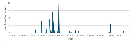
Figure 1: Tornado reports according to date in 2024.
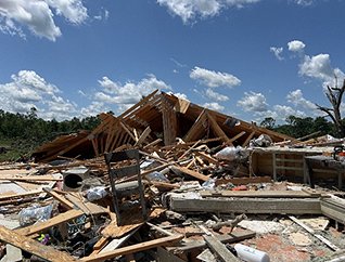
Figure 2: Damaged home in Howell County after the May 26 EF-3 tornado.
(Photo courtesy of Springfield, MO NWS Office)
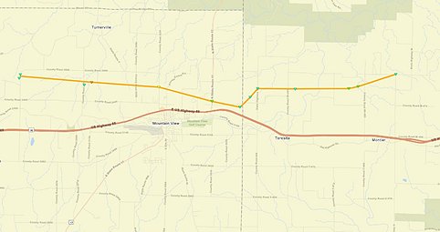
Figure 3. The path of the May 26 EF-3 tornado (yellow) along I-60 (red).
(Photo courtesy of Springfield, MO NWS Office)
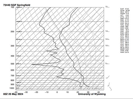
Figure 4: Springfield (KSGF) sounding produced moments before the first storms moved in.
(Photo courtesy of Wyoming Weather Web)
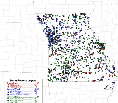
Figure 5. Map of storm reports from 2024.
(Image courtesy of Storm Prediction Center).
Source: Evan Cargill and Dr. Zachary Leasor | 573-882-5908