
December 2021 Weather and Its Impacts on Missouri
Pat Guinan
Extension/State Climatologist
University of Missouri
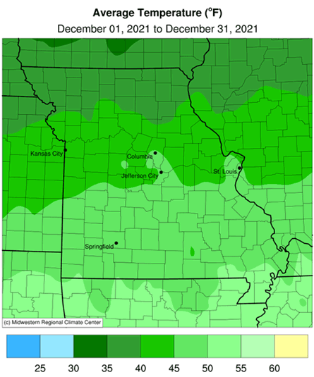
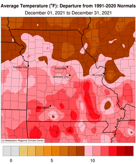
The mild Missouri fall weather continued into December with above average daily temperatures occurring for much of the month, Figure 1. Preliminary data indicated an average statewide December temperature of 44.3°F, or 11.3° above the long-term average (1901-2000). It was Missouri's warmest December in the past 127 years (1895-2021) and surpassed the previous record set in 2015, Figure 2. There have been only two colder than average Decembers over the past 11 years (2013 & 2016).
It was an up and down year in regard to monthly temperature departures with 8 months above normal and 4 months cooler than average. The biggest anomalies occurred in February (7th coldest), March (11th warmest) and December (1st warmest), Figure 3. Preliminary data indicate the annual statewide temperature average was 56.3°F, or 1.8° above the long-term average. Nineteen out of the past twenty-four years (79%) in Missouri have been warmer than average, Figure 4.
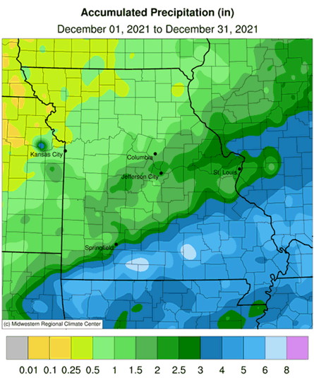
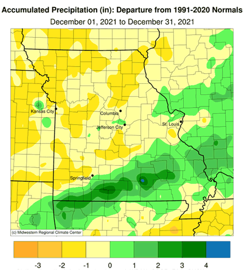
December was slightly drier than average with preliminary precipitation data indicating a statewide average total of 2.37 inches, or 0.14 inches below the long-term average (1901-2000). Five out of the past six Decembers have been below average, Figure 5.
For the year, 7 months were wetter than average and 5 months below average, Figure 6. The biggest anomalies occurred in January (18th wettest), March (12th wettest), September (26th driest), October (9th wettest) and November (17th driest).
Around the state, December precipitation was variable and generally increased from northwest to southeast. Much of northern Missouri received less than 1-inch, with several northwestern counties reporting less than 0.50 inches. West central sections reported 0.5-1.5 inches, with most of central, east central and far southwestern Missouri receiving 1.5-2.5 inches. Heavier totals ranged from 2.5 to 5-inches across southern Missouri and increased along a gradient southeast of I-44.
Total preliminary statewide average annual precipitation for 2021 was 43.94 inches or 3.44 inches above the long-term average. Only three years have been drier than average since 2008, Figure 7. Annual radar estimates indicate heaviest precipitation fell over portions of northeastern, central, west central, and southern Missouri, Figure 8. Some of the heaviest annual precipitation reports for 2021 are listed in Table 1.
| Heaviest Missouri Precipitation Totals for 2021 | ||
| Station Name* | County | Precipitation (in.) |
| Poplar Bluff | Butler | 66.17 |
| Pineville 7.5ESE | McDonald | 66.15 |
| Neosho 3.9WNW | Newton | 64.55 |
| Springfield 4.9SE | Greene | 61.25 |
| Wasola 5N | Douglas | 60.72 |
| Seligman 3.0N | Barry | 59.55 |
| Mountain View 7.0NE | Shannon | 59.17 |
| Bolivar 1NE | Polk | 59.09 |
| Scott City 0.9E | Scott | 58.42 |
| *Rain gauges from NWS Cooperative and CoCoRaHS reports | ||
| Table 1. | ||
No winter storms were reported in December, but two unusual severe storm outbreaks impacted the Show Me State during the month.
The first event was a deadly late season multi-state tornado outbreak on December 10-11 impacting Arkansas, Missouri, Illinois, Tennessee and Kentucky, Figure 9. National Weather Service surveys documented six tornadoes in Missouri during the evening of December 10th, with two fatalities. A long-track EF4 tornado crossed the Missouri Bootheel from Arkansas and tore through Dunklin and Pemiscot Counties. The tornado path was reported to be just over a mile wide in places with estimated peak winds at 170 mph. Numerous homes were damaged or destroyed and one fatality was reported in Pemiscot Co., near the community of Braggadocio. Another deadly tornado, with estimated peak winds of 165 mph, impacted St. Charles and St. Louis Counties, in east central Missouri. The tornado destroyed a couple homes near the community of Defiance where one fatality was reported.
The second severe storm outbreak occurred on December 15th when an intense low pressure system in Kansas initiated a squall line of severe thunderstorms and tornadoes that swept through portions of Kansas, Nebraska, Missouri, Iowa, Minnesota and Wisconsin. The magnitude and intensity of the event fit the criteria for a derecho - where wind damage extended more than 250 miles and was accompanied by wind gusts of at least 58 mph. This was the first December derecho ever documented in the United States, as well as the largest severe storm December outbreak ever witnessed in the region, Figure 10.
The unseasonably mild December weather translated to lower than usual energy consumption and less stressful conditions for outdoor workers, livestock and pets. As of December 28, 2021, the U.S. Drought Monitor map indicated abnormally dry conditions impacting portions of northern, central and southeastern Missouri and a pocket of moderate drought impacting east central Missouri, Figure 11. There was also a small area of severe drought noted across southern St. Charles County.
Jump to:
- Figure 1
- Figure 2
- Figure 3
- Figure 4
- Figure 5
- Figure 6
- Figure 7
- Figure 8
- Figure 9
- Figure 10
- Figure 11
- Figure 12
- Figure 13
- Figure 14
- Figure 15
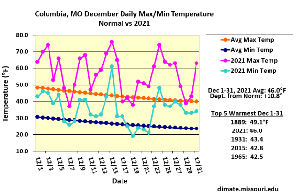
Figure 1.
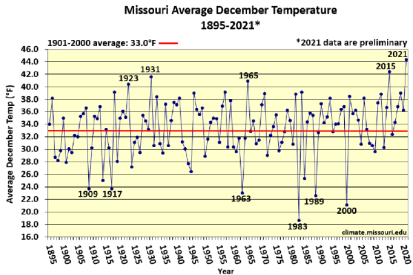
Figure 2.
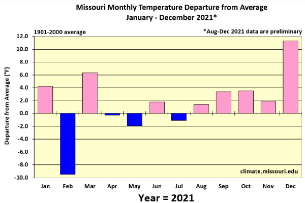
Figure 3.
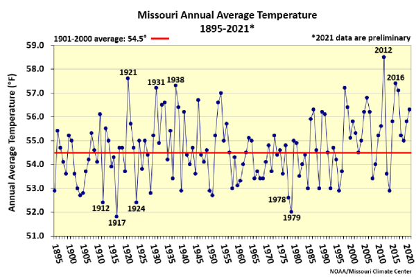
Figure 4.
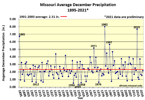
Figure 5.
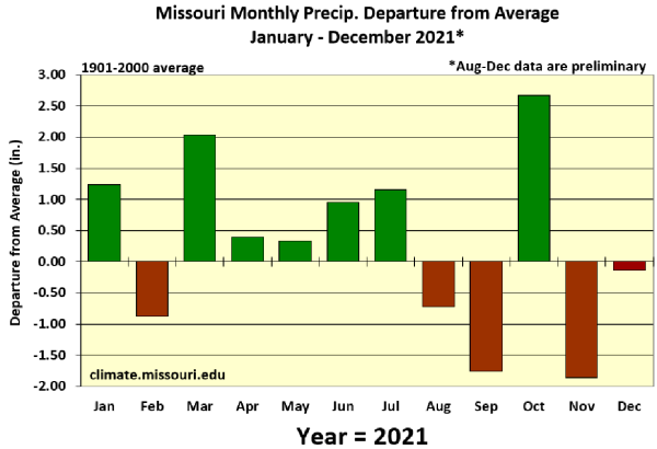
Figure 6.
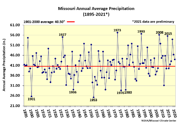
Figure 7.

Figure 8.
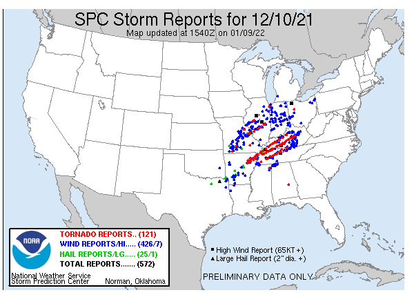
Figure 9.
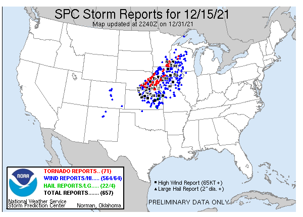
Figure 10.
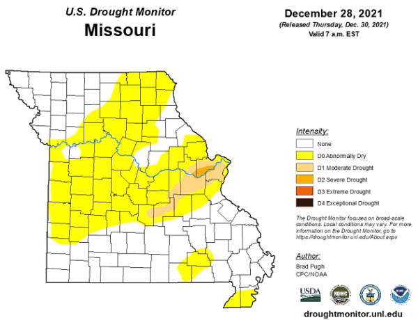
Figure 11.
Source: Pat Guinan, 573-882-5908