
December 2020 Weather and Its Impacts on Missouri
Pat Guinan
State Climatologist
University of Missouri Extension
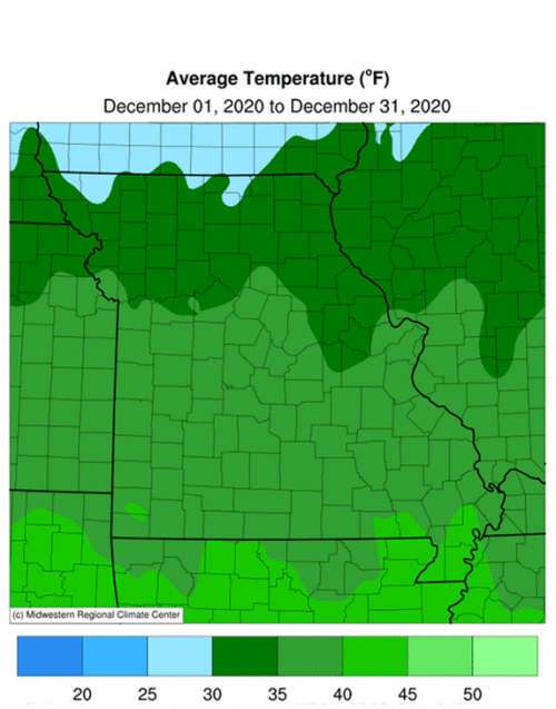
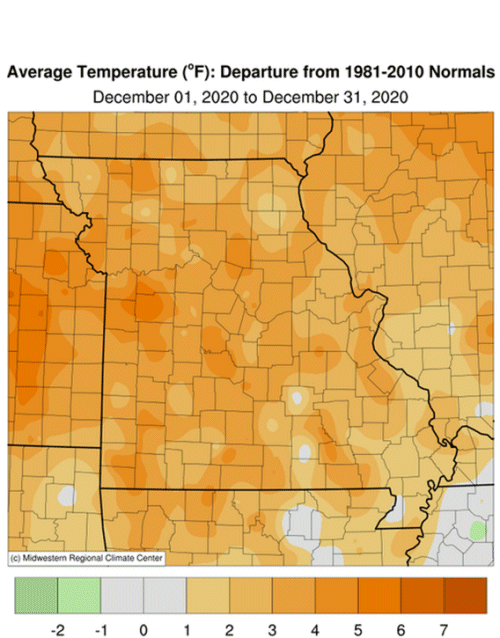
The mild Missouri weather from November continued into December with above normal temperatures occurring for much of the month, Figure 1. Preliminary data indicate the average statewide December temperature for Missouri was 36.3°F, or 3.0° above the long-term average (1895-2020). There have been only two cooler than average Decembers over the past decade (2013 & 2016), Figure 2.
It was an up and down year in regard to monthly temperature anomalies with 7 months above normal and 5 months below normal, but warmer months had larger departures, especially in January, March and November, Figure 3. Preliminary data indicate the annual statewide temperature average was 55.7°F, or 1.1° above the long-term average (1895-2020). Eighteen out of the past twenty-three years (78%) in Missouri have been warmer than average, Figure 4.
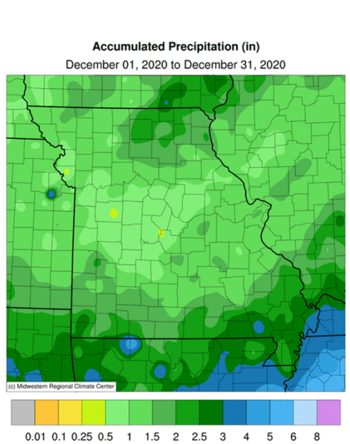
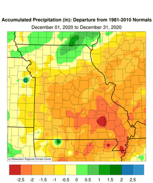
December was a drier than average month with preliminary precipitation data indicating a statewide average total of 1.46 inches, or 0.91 inches below the long-term average (1895-2020). Four out of the past five Decembers have been below average, Figure 5. For the year, there were 7 months wetter than average and 5 months below average, Figure 6.
Total preliminary statewide average precipitation for 2020 was 46.19 inches or 5.07 inches above the long-term average (1895-2020), Figure 7. Only three years have been drier than average since 2008. Annual radar estimates for 2020 indicate an increasing rainfall gradient from north to south with much of northern Missouri receiving less than 40-inches, central portions between 40-50 inches, and most of southern Missouri receiving more than 50 inches, Figure 8. Some of the heaviest annual precipitation reports for 2020 are listed in Table 1.
| Heaviest Precipitation Totals for 2020 | |||
| Station Name* | County |
Precipitation (in) | |
| Mountain View 7.0NE | Shannon | 70.16 | |
| Dexter 2.3W | Stoddard | 67.72 | |
| Summersville 3.6S | Texas | 67.09 | |
| Ava 0.8NNW | Douglas | 66.90 | |
| Poplar Bluff 4.2NW | Butler | 66.42 | |
| Sikeston 1.7ENE | Scott | 66.09 | |
| Ellsinore 4.8WNW | Carter | 65.52 | |
| Branson Airport | Taney | 65.31 | |
| Doniphan 14.5NW | Ripley | 64.70 | |
| *Rain gauges from NWS Coop and CoCoRaHS reports | |||
| Table 1. | |||
December rain gauge observations indicate heaviest precipitation totals occurred over far southern Missouri as well as a few counties in northeastern sections where 2-3 inches were reported. Much of the rest of state reported 1-2 inches and a few locations, mostly in central and west central Missouri, reported less than 1-inch for the month.
Notable December snow events were sparse with only a couple reported. The first event impacted far southwestern Missouri with reports of 2-4 inches on December 14th. Another event dropped 1-3 inches of snow across northern Missouri on December 30th.
The seasonably mild December weather translated to lower than usual energy consumption and less stressful conditions for outdoor workers, exposed livestock and pets. As of December 29, 2020, the U.S. Drought Monitor map indicated abnormally dry conditions to moderate drought impacting much of the northern half of Missouri, Figure 9. Slivers of abnormally dry conditions were also reported in far southeastern Missouri.
Jump to:
- Figure 1
- Figure 2
- Figure 3
- Figure 4
- Figure 5
- Figure 6
- Figure 7
- Figure 8
- Figure 9
- Figure 10
- Figure 11
- Figure 12
- Figure 13
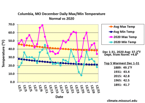
Figure 1.
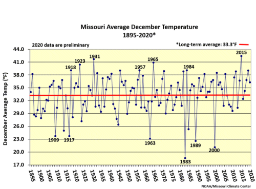
Figure 2.
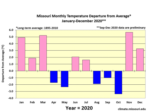
Figure 3.
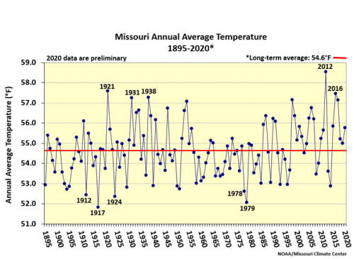
Figure 4.
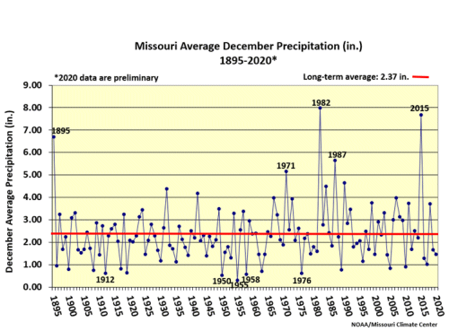
Figure 5.
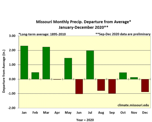
Figure 6.
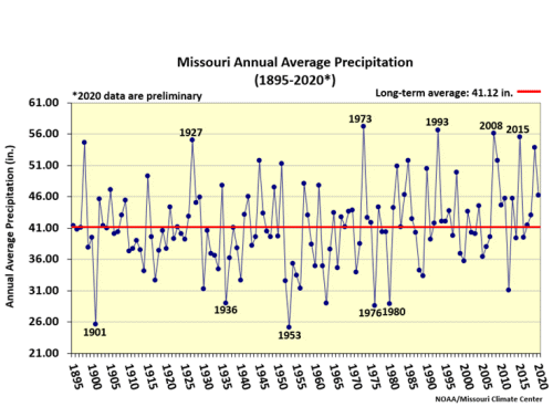
Figure 7.
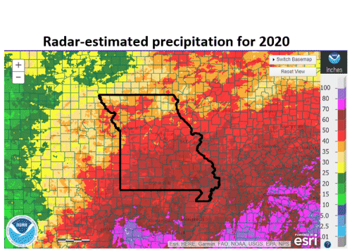
Figure 8.
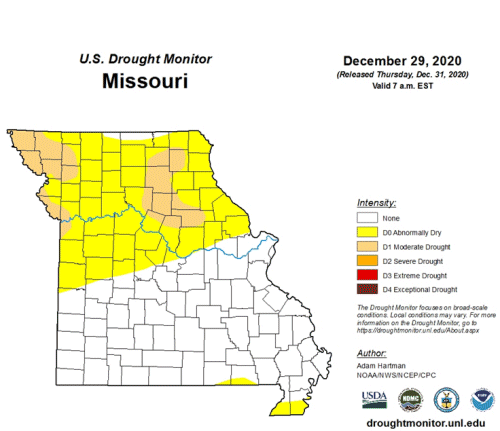
Figure 9.
Source: Pat Guinan, 573-882-5908