
December 2014 Weather and Its Impacts on Missouri
Pat Guinan
State Climatologist
Commercial Agriculture/University of Missouri Extension
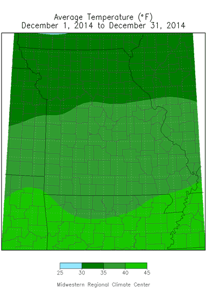
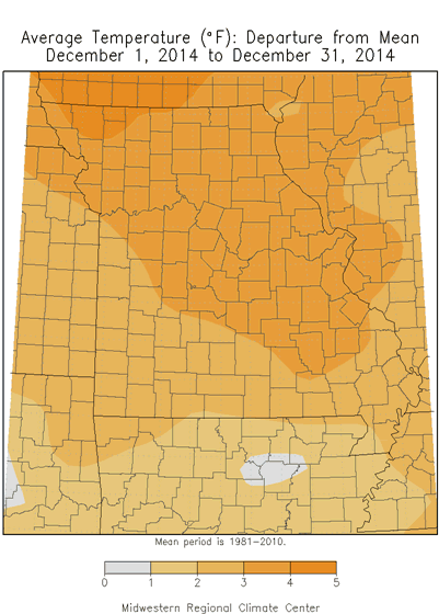
December temperatures for Missouri were warmer than normal, with preliminary data indicating a statewide average of 36.0°F, or 3 degrees above the long-term average. December temperatures have trended warmer over the past couple decades with 2000 being the only notable cold December, Figure 1. Most of the warmth during December 2014 was due to above normal minimum temperatures, Figure 2. Extended cloudy periods kept nighttime temperatures seasonably mild and maximum temperatures near average, leading to small diurnal temperature ranges for December of 11 to 13 degrees; 18 to 20 degree ranges are more typical.
The warm temperature anomaly for December ran counter to the unusually cool weather that dominated in 2014, Figure 3. Preliminary temperature data for 2014 indicates it was the coolest in 35 years, or since 1979, and the 9th coolest year on record, Figure 4 and Table 1. Any slight adjustment in the 2014 average could impact the ranking.
Anyone with light deprivation sensitivities were likely aware of the extraordinary number of cloudy days during the month. December is typically Missouri's cloudiest month with the lowest average number of sunlight hours per day, but this year December was unusually cloudy. Figure 5 shows the average amount of December solar radiation measured for Columbia, Missouri over the past 20 years. December 2014 was the lowest over the past two decades, eclipsing two other low sunshine Decembers in 2007 and 2009. There were 18 cloudy days, 9 partly cloudy days and 4 full sunshine days in Columbia this year for December, Figure 6.
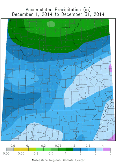
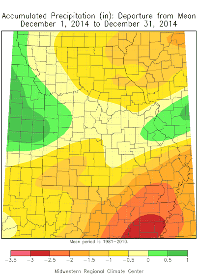
Preliminary precipitation data for December indicates a statewide average of 2.15 inches, which is slightly below average, Figure 7. Regional precipitation totals for December ranged from 0.75-1.50 inches across northern sections, 1.50-2.50 inches over west central and southwestern Missouri and 2.50-3.50 in east central and southeastern portions. The largest and smallest CoCoRaHS totals for the month were 4.14 inches in Ste. Genevieve county and 0.43 inches in Putnam county. The only notable snow event to impact the state occurred overnight on December 17-18 when 3-5 inches of heavy, wet snow fell just north of Kansas City to St. Joseph, MO, and eastward along Highway 36 into parts of north central Missouri, Figure 8.
Similarly, slightly below average precipitation fell in 2014 with a statewide average of 39.27 inches, 1.59 inches below the long-term average, Figure 9. However, there were notable annual precipitation deficits, exceeding 10 inches, over portions of south central and southwestern Missouri, Figure 10.
Jump to:
- Figure 1
- Figure 2
- Figure 3
- Figure 4
- Table 1
- Figure 5
- Figure 6
- Figure 7
- Figure 8
- Figure 9
- Figure 10
- Figure 11
- Figure 12
- Figure 13
- Figure 14
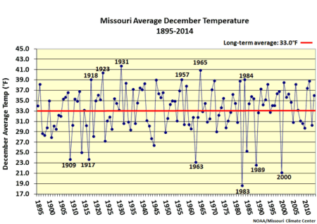
Figure 1.
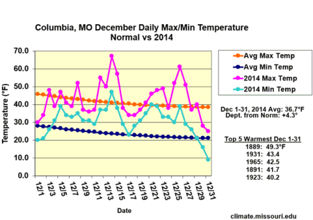
Figure 2.
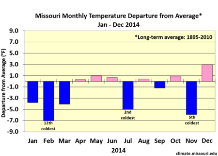
Figure 3.
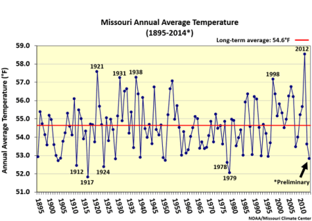
Figure 4.
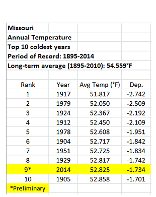
Table 1.
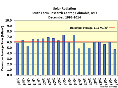
Figure 5.
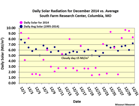
Figure 6.
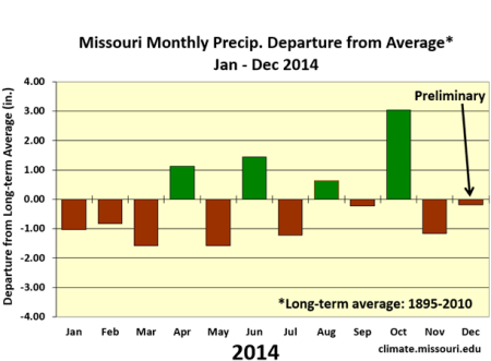
Figure 7.
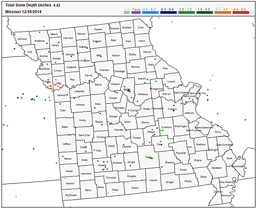
Figure 8.
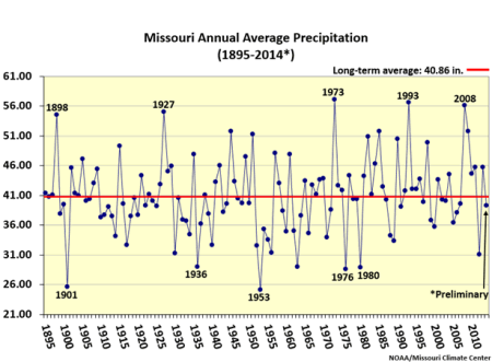
Figure 9.
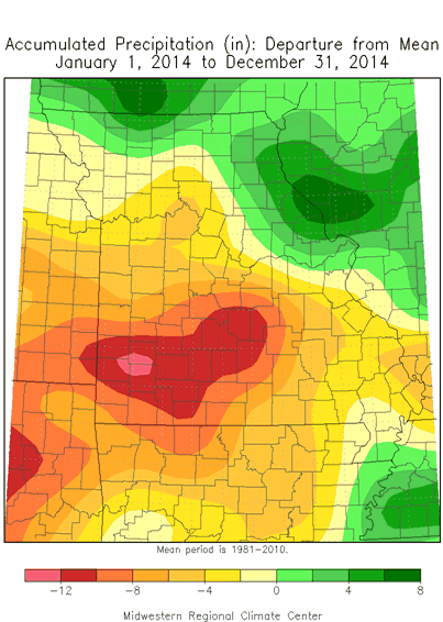
Figure 10.
Source: Pat Guinan, 573-882-5908