
December 2013 Weather and Its Impacts on Missouri
Pat Guinan
State Climatologist
Commercial Agriculture/University of Missouri Extension
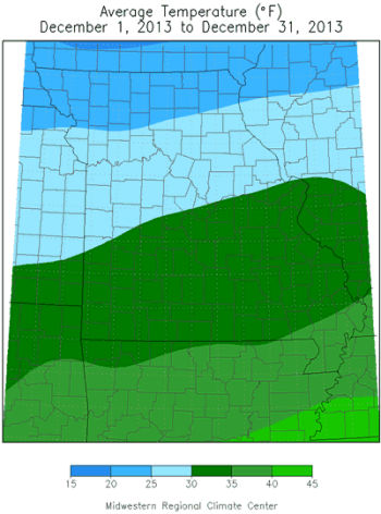
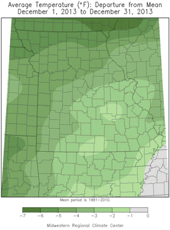
The cool trend that dominated for much of the year persisted through December. Preliminary temperature data for Missouri indicate a statewide average December temperature of 29.8°F, or 3.5 degrees below the long-term normal for the month. It was the coldest December since 2010, Figure 1. Monthly temperatures averaged 4-5 degrees below normal across northern sections, 3-4 degrees below normal over central and southwestern Missouri, and 1-3 degrees below normal in south central and southeastern parts of the state.
Only 3 months were warmer than normal in 2013 (Jan, Feb, Sep), Figure 2, and preliminary data indicate an annual average statewide temperature of 53.5°F, or 1.1°F below the long-term average. Incredibly, 2013 was nearly 5 degrees cooler than 2012, Missouri's warmest year on record. Additionally, 2013 was only the fourth time since 1998 when the annual average temperature in Missouri was below normal, Figure 3.
A progressive weather pattern prevailed during December, with brief warm spells followed by extended periods of arctic incursions, Figure 4. Record highs and lows were established on some days with Kansas City dropping to 0°F on the morning of the 7th, breaking the previous record of 1°F set in 1976. St. Louis reached a spring-like 71°F on Dec 20, and eclipsed the record established in 1978 of 68°F. Bitterly cold temperatures were witnessed on Christmas Eve morning across parts of northern Missouri where some snow-covered locations experienced their coldest temperatures in more than a decade. The Hundley-Whaley Farm Ag Weather Station in Albany, MO reported -25°F on 12/24 and was the coldest temperature experienced at the location since February 3, 1996, when the mercury bottomed out at -27°F. A National Weather Service cooperative weather station located 2 miles east of Maryville dropped to -28°F on Christmas Eve morning, and was the coldest temperature experienced theresince Dec 23, 1989, when -28°F was observed.
The below normal temperatures, in combination with an active weather pattern, resulted in several winter storm events across the state. An unusually early heavy snow event impacted southern sections of the state during the first week of December with several inches of snow falling southeast of I-44, from St. Louis to Joplin, Figure 5. Some of the heaviest snowfall totals include Ste. Genevieve (Ste. Genevieve Co.), Annapolis (Iron Co.), Bismarck (St. Francois Co.) and Belleview (Iron Co.) with 11", 11", 12", and 13", respectively. Another snow event impacted southwestern sections on December 9th with 4-6 inches reported from Springfield to Lebanon, Figure 6. Parts of northeastern, central, and east central Missouri received 2-8 inches of snow on December 13-14, Figure 7, and 4-9 inches fell north of a line from Kansas City to Kirksville on December 20-21, Figure 8. Sleet and freezing rain fell south of this line during the event and deposited a 0.25-0.30" layer of ice on trees and power lines from Quincy to Columbia to Nevada, Figure 9. Ice thicknesses approached 0.50" from Clinton to north of Joplin and led to some tree damage and power outages.
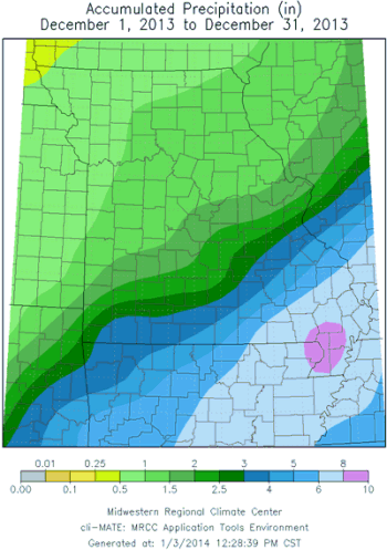
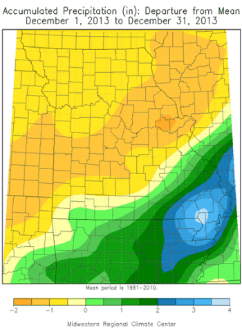
Preliminary precipitation data indicate and average statewide total of 2.5 inches, which is near normal for December. Only far southeastern Missouri and the southern border counties received above normal precipitation. Totals increased southeastward through the state and ranged from 0.50-1.0 inch across northwestern Missouri and the northern border counties, 1-2 inches over northeastern and central sections, and around two inches along I-44, from Joplin to Lebanon to St. Louis. Amounts increased to more than 6-inches in far southeastern Missouri.
Some of the lightest monthly totals were observed in Liberty (Clay Co.), Unionville (Putnam Co.) and Grant City (Worth Co.) where 0.45", 0.44" and 0.27" were reported, respectively. Heaviest precipitation amounts were observed in Anniston (Mississippi Co.) and New Madrid (New Madrid Co.), with 8.94" and 9.06" reported, respectively.
The year end Drought Monitor map for 2013 indicated abnormally dry to moderate drought conditions impacting much of northern and central Missouri, Figure 10. Significant precipitation deficits have accumulated since June and hydrologic resources across northern and central Missouri have not fully recovered.
Jump to:
- Figure 1
- Figure 2
- Figure 3
- Figure 4
- Figure 5
- Figure 6
- Figure 7
- Figure 8
- Figure 9
- Figure 10
- Figure 11
- Figure 12
- Figure 13
- Figure 14
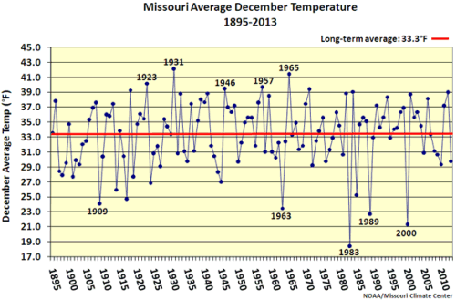
Figure 1
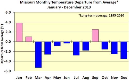
Figure 2
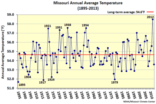
Figure 3
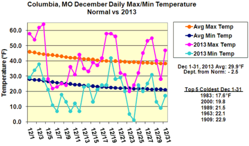
Figure 4
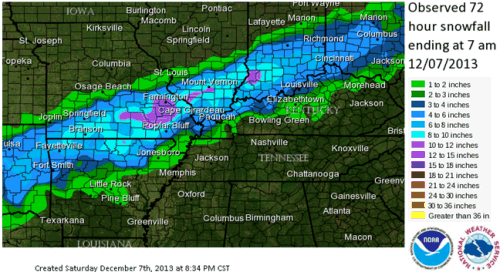
Figure 5 - Source: NOAA/NWS
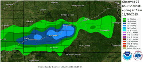
Figure 6 - Source: NOAA/NWS
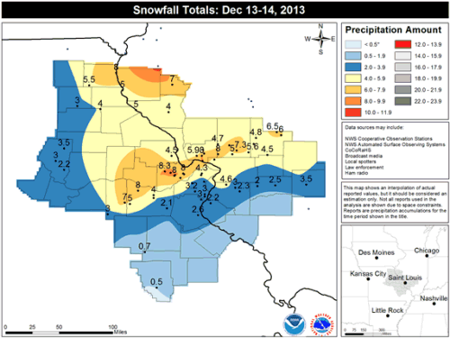
Figure 7 - Source: NOAA/NWS
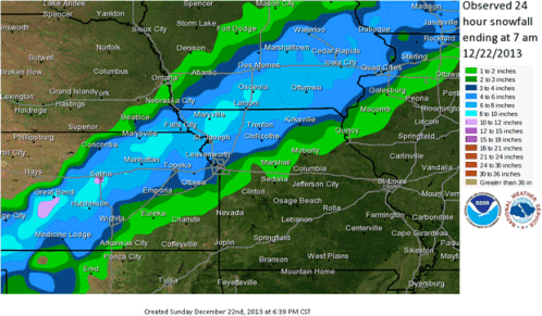
Figure 8 - Source: NOAA/NWS
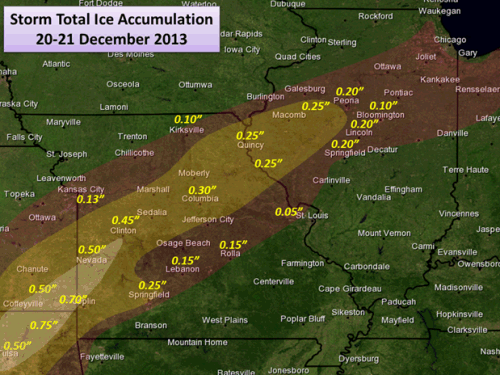
Figure 9 - Source: NWS Forecast Office, St. Louis, MO
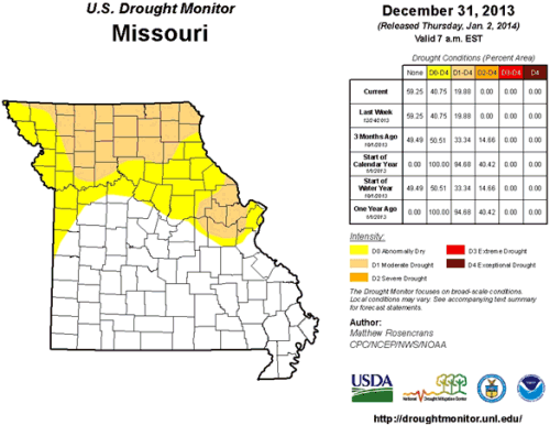
Figure 10
Source: Pat Guinan, 573-882-5908