December 2010 Weather and Its Impacts on Missouri
Pat Guinan
State Climatologist
Commercial Agriculture/University of Missouri Extension
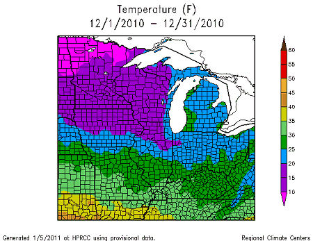
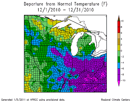
For the first time since February, below normal temperatures were experienced across Missouri during the month of December. Preliminary data indicated an average statewide temperature of 30°F, which is 3 degrees below normal for the state. A northwesterly upper air flow pattern dominated during the first 3 weeks of the month and brought reinforcing shots of arctic air into the region. Coldest temperatures occurred on the morning of the 13th when single digit to below zero temperatures encompassed much of the state. A short-lived pattern shift during the last few days of the month resulted in much warmer conditions with maximum temperatures climbing into the 50 and 60’s on the 30th and 31st.
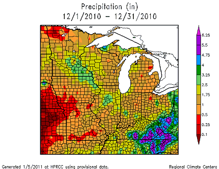
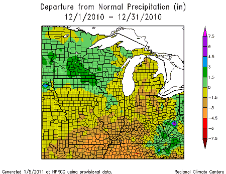
The dominant cold weather pattern resulted in few opportunities for significant precipitation events. Statewide precipitation averaged around 1-inch, which is a little less than 1-inch below normal for Missouri. It was the third consecutive month with below normal precipitation and it was the 8th driest October-December on record for the state.
Northwestern sections and pockets of south central and southwestern Missouri reported the least amount of precipitation where less than 0.5 inches were common in some counties. Generally, 0.5-1.25 inches were typical across north central, northeast, west central, southwestern and south central sections. Heavier amounts, ranging from 1.25-2.25 inches, fell over parts of central and east central Missouri and the Bootheel.
Some locations reporting the lowest monthly precipitation totals were West Plains, Liberty and Galena with 0.09, 0.07, and 0.05 inches, respectively. Heaviest monthly totals were found in Montgomery City, Marshfield and Conway where 2.65, 2.81, and 3.34 inches were reported, respectively.
Some notable weather impacts that occurred during the month include two snow events on December 11-12th and December 24th, an icing event on the 15th, and a deadly tornado outbreak on New Year’s Eve.
A winter storm impacted the state on December 11-12th and dropped 1-3 inches of snow across the northeastern half of Missouri. The snow was accompanied with strong and gusty winds and created hazardous driving conditions. The snow blanket remained for several days as arctic air settled into the state.
A weak disturbance brought freezing drizzle to central and southern sections of the state during the afternoon and evening hours of the 15th and resulted in a thin coating of ice on all surfaces, including roadways. Many drivers were unaware of the icy conditions and numerous vehicle accidents were reported, including some fatalities. Portions of I-55, I-44 and I-70 were shut down to due to multiple accidents and jackknifed semis.
Another winter storm impacted the state on Christmas Eve and Christmas day and dropped 1-6 inches of snow across the northeastern half of the state. For some locations, it was the first White Christmas since 2002. Some of the higher snowfall amounts were reported at the following locations:
Snowfall (in.)
Columbia: 6.0
Vandalia: 6.0
Williamsburg: 5.5
DeSoto: 5.5
Bowling Green:5.0
An extraordinary tornado outbreak occurred on December 30-31 and preliminary surveys indicate it was the largest single day tornado outbreak on record in Missouri for the month of December. National Weather Service surveys determined 2 tornadoes touched down on December 30, shortly before midnight, and 17 tornadoes touched down on New Year’s Eve. The New Year’s Eve total surpasses the previous single day December record of 15 tornadoes on December 2, 1982. Despite December 30-31 being the only days with reported tornadoes for the month, the 19 tornado touchdowns rank the month as the second most active December since 1950. Only December 1982 was more active when 28 tornadoes were documented.
The December 30-31 outbreak was confined to southern and east central sections of the state with tornadoes confirmed in Stone, Christian, Webster, Polk, Pulaski, Dent, Phelps, Carter, Butler, Franklin, St. Louis, St. Charles, and Jefferson counties and St. Louis city. According to the surveys, 7 tornadoes were classified as EF0, 6 tornadoes as EF1, 3 tornadoes as EF2 and 3 tornadoes as EF3. There were numerous reports of commercial, residential, property and tree damage and, unfortunately, 4 fatalities.
Two fatalities occurred near the community of Lecoma when an EF1 tornado destroyed a mobile home in Dent County. Winds were estimated between 90-100 mph. Another deadly tornado, with EF3 intensity, touched down just northwest of Rolla, in Phelps County. The tornado destroyed two single wide mobile homes and two occupants in one of the mobile homes perished.