January 2024 Weather and Its Impacts on Missouri
Dr. Zack Leasor
State Climatologist
Assistant Professor
January 2024 featured colder and wetter conditions across the state of Missouri. January's statewide average temperature of 27.9 °F was -1.5 °F below the long-term average and ranked as Missouri's 40th coldest January back to 1895. January was the first month with below normal average temperatures in 14 months, going back to October of 2022.
Despite January 2024 being colder than average, there were generally more days with near normal temperatures as the only significant stretch of cold temperatures occurred from January 12 - 21. During this period, the state experienced an extended period with temperatures below zero and extreme nighttime lows and wind chill values (Table 1)
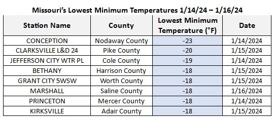
Table 1. Data provided by NOAA's Applied Climate Information System (ACIS)
Several daily minimum temperature and low maximum temperature records were broken, and January 14, 2024 was one of the coldest days on record for the state. Columbia tied for the 6th lowest maximum daily temperature (-2 °F) on record, making it the coldest day since December 22, 1989.
With temperatures at least 15 to 25 degrees Fahrenheit below normal for over a week (Figure 1), this stretch of brutal cold had a significant impact on the month's average temperature. Impacts from this stretch of extreme cold included school and business closures, frozen pipes, isolated power outages, stress on livestock, and frozen creeks and streams. Some public parks even allowed for recreation activities on ponds where the ice thickness was sufficient due to the extreme cold.
Missouri's statewide average precipitation in January was 3.51" making it the 13th wettest January with total precipitation 1.42" above the long-term average. Precipitation totals were highest in southeast Missouri where nine counties recorded greater than seven inches of rainfall.
Above normal precipitation in January was beneficial for drought recovery in Missouri. Widespread reduction in drought severity and areal coverage between January 2 and February 6 were noted by the US Drought Monitor (Figure 3). The percentage of Missouri in drought decreased from 71.5% on January 2 to just 15.1% on February 6 and all remaining areas of severe and extreme drought classifications were removed.
Even with the stretch of cold temperatures in mid-January, much of the month's precipitation helped to recharge low soil moisture across the state. By the end of the month, streamflow was near to above normal across most of Missouri's creeks and streamflow with improvements to streamflow also noted along the Missouri and Mississippi Rivers.
Some of Missouri's precipitation came in the form of snowfall with areas north of the Missouri River receiving 6-18" of snowfall in January (Figure 4). Most of the snowfall was received during several events occurring in early and mid-January.
There was a sharp divide in January snow totals as the southern half of the state received little snowfall despite the colder temperatures. Combined with an unusually warm December, this has left a large portion of Missouri running well behind on seasonal snowfall through the end of January 2024 (Figure 5). Only northwest and extreme northern Missouri have recorded near to above normal snowfall so far this winter season.
Jump to:
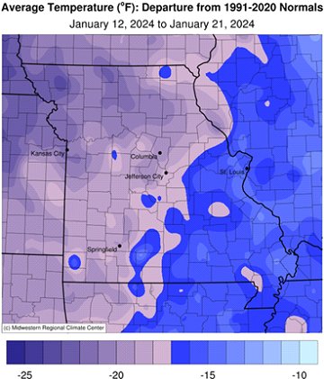
Figure 1.
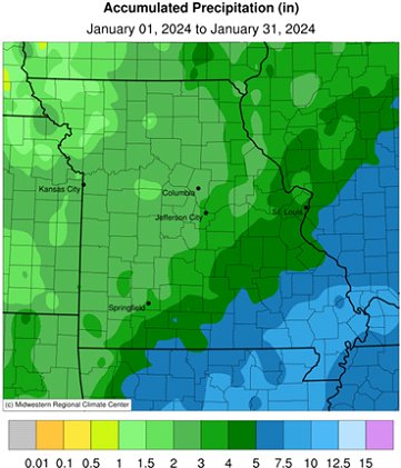
Figure 2.
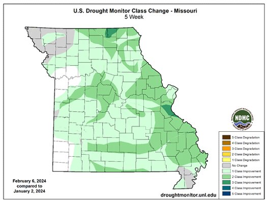
Figure 3.
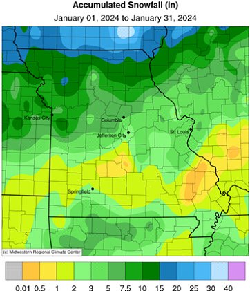
Figure 4.
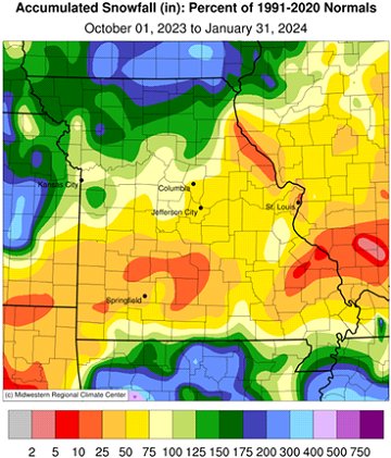
Figure 5.
Source: Dr. Zack Leasor | 573-882-5908


