
January 2022 Weather and Its Impacts on Missouri
Pat Guinan
State Climatologist
University of Missouri Extension
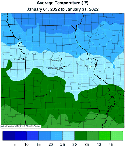
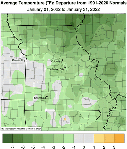
Large temperature fluctuations were the rule in Missouri during January, from periods of below normal temperatures to strings of seasonably mild days, Figure 1. A meandering jet stream within northwesterly flow was the culprit for the "roller coaster" weather pattern. Every few days, frontal boundaries would sweep through the state bringing with them occasional incursions of Canadian arctic air. Preliminary data indicate the average statewide temperature for January was 28.4°F, 1.0 degree below the long-term average (1901-2000). It was the first colder than average January since 2018, Figure 2, and the first below average month since July of last year, Figure 3.
Coldest minimum temperatures occurred across northern Missouri with some double-digit below zero reports, Table 1. Sub-zero temperatures generally impacted the northern half of the state and some low-lying areas of the Ozarks. Warmest daily high temperatures reached the middle 60s and were reported on the first and last day of January, Table 2.
The seasonably cold January conditions contrasted notably with the previous record warm December, and translated to higher energy consumption and more days with bitter cold and wind chill for outdoor workers, exposed livestock and pets.
| January 2022 Extreme Minimum Daily Temperatures in Missouri | |||
| Location* | County | Min Temp (°F) | Date |
| Green City 5N | Sullivan | -12 | 21 |
| Conception | Nodaway | -11 | 3 |
| Memphis | Scotland | -10 | 22 |
| Grant City 5WSW | Worth | -9 | 2 |
| Novelty 1E | Knox | -9 | 21 |
| Albany | Gentry | -8 | 3 |
| Corning (Graves-Chapple) | Atchison | -8 | 2 |
| Kirksville Regional AP | Adair | -8 | 21 |
| Unionville | Putnam | -8 | 2 |
| Princeton | Mercer | -7 | 3 |
| Tarkio #2 | Atchison | -7 | 3 |
| *NWS Cooperative network and Missouri Mesonet | |||
| Table 1. | |||
| January 2022 Extreme Maximum Daily Temperatures in Missouri | |||
| Location* | County | Max Temp (°F) | Date |
| Kansas City Downtown AP | Clay | 66 | 31 |
| Lamar 1W | Barton | 66 | 31 |
| Kansas City Intl AP | Platte | 65 | 31 |
| Mount Vernon SW Center | Lawrence | 65 | 31 |
| Steele 6W | Pemiscot | 65 | 1 |
| Cardwell | Dunklin | 64 | 1 |
| Corning (Graves-Chapple) | Atchison | 64 | 31 |
| Green Ridge | Pettis | 64 | 31 |
| Hayward (Lee Farm) | Pemiscot | 64 | 1 |
| Portageville (Delta Center) | Pemiscot | 64 | 1 |
| Senath 2NE | Dunklin | 64 | 1 |
| *NWS Cooperative network and Missouri Mesonet | |||
| Table 2. | |||
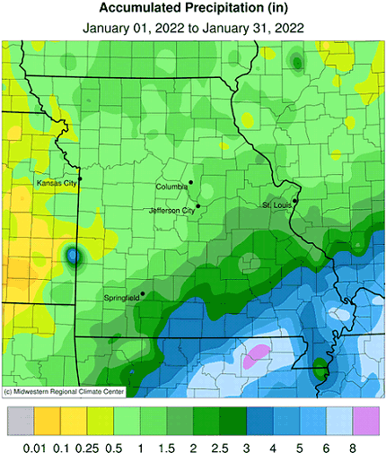
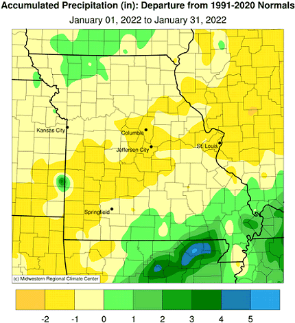
Preliminary precipitation data indicated a statewide average of 1.62 inches, 0.47 inches below the long-term average. It was the first drier than average January since 2018, Figure 4. Five out the past 6 months have been drier than normal, Figure 5. Most of the state reported below average precipitation with the exception of far south central and southeastern Missouri and a few counties in northwestern sections where precipitation was slightly above average.
According to radar estimates, Figure 6, portions of northwestern, west central, central and southwestern Missouri reported less than 1.50 inches for the month. Driest estimates, less than 0.50 inches, were found in pockets of northwestern and west central Missouri and some southwestern border counties. Wetter conditions were indicated in east central, south central and southeastern Missouri, where 1.50 to 3-inches were common. Heaviest totals of 3 to 5+ inches were located in far southeastern sections. Lightest and heaviest rain gauge reports are listed in Table 3.
| Missouri Rain Gauge Reports for January 1-31, 2022 | |||
| Station Name* | County | Precipitation (in.) | |
| Lightest | St. Joseph 4.4E | Buchanan | 0.35 |
| Gower 2.7S | Clinton | 0.40 | |
| Nevada Water Plant | Vernon | 0.42 | |
| Marshall | Saline | 0.45 | |
| Appleton City 1.9NW | Bates | 0.46 | |
| Forest City 6.9N | Holt | 0.47 | |
| Rosendale 2.6ESE | Andrew | 0.48 | |
| Heaviest | Sikeston Power Station | Scott | 7.04 |
| Portageville Delta Center | Pemiscot | 6.91 | |
| Steele 6W | Pemiscot | 6.67 | |
| Poplar Bluff | Butler | 6.01 | |
| Hayward (Lee Farm) | Pemiscot | 5.91 | |
| Senath 2NE | Dunklin | 5.91 | |
| *Rain gauges are from the NWS Cooperative Network, CoCoRaHS, and Missouri Mesonet | |||
| Table 3. | |||
There were a couple notable snow events during the month, with the first one impacting parts of northern Missouri on Jan 1-2, where 2-4 inches were common, Figure 7. A widespread, and heavier event impacted most of the state on January 15-16. Snowfall amounts ranged between 2-8 inches, Figure 8.
According to the U.S. Drought Monitor, nearly 40% of Missouri was reported to be abnormally dry toward the end of January, Figure 9.
Jump to:
- Figure 1
- Figure 2
- Figure 3
- Figure 4
- Figure 5
- Figure 6
- Figure 7
- Figure 8
- Figure 9
- Figure 10
- Figure 11
- Figure 12
- Figure 13

Figure 1.
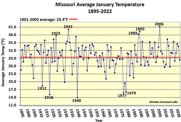
Figure 2.
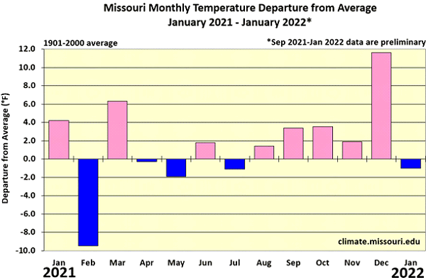
Figure 3.
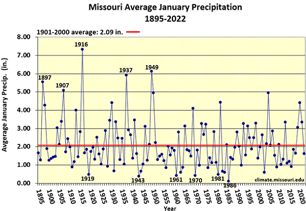
Figure 4.
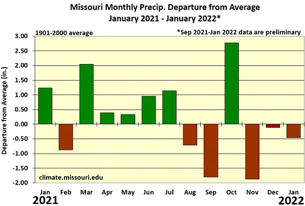
Figure 5.
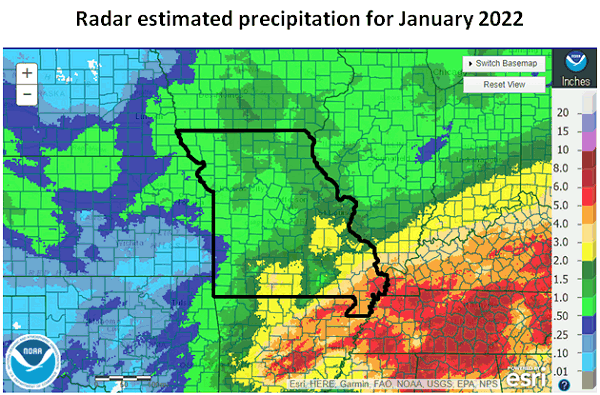
Figure 6.
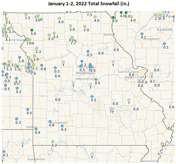
Figure 7. CoCoRaHS total snowfall map, January 1-2, 2022.
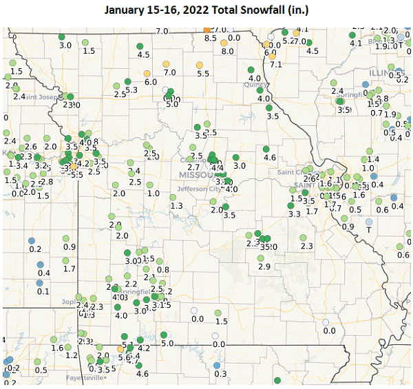
Figure 8. CoCoRaHS total snowfall map, January 15-16, 2022.
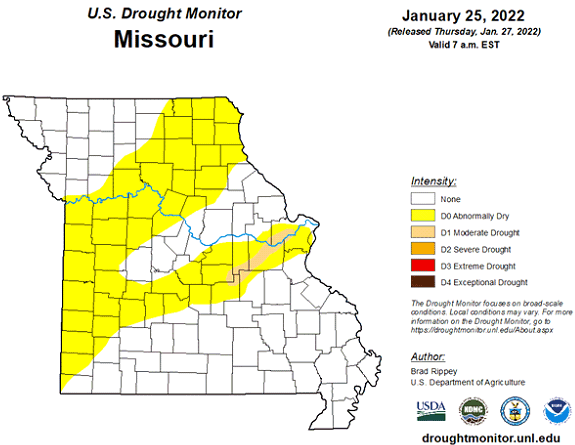
Figure 9.
Source: Pat Guinan, 573-882-5908