
January 2019 Weather and Its Impacts on Missouri
Pat Guinan
State Climatologist
University of Missouri Extension
An unsettled weather pattern impacted Missouri in January with several precipitation events, including a 2-day snowstorm which dropped more than a foot of snow over parts of central Missouri. An extended cloudy period occurred during the second and third week of January, suppressing maximum temperatures while elevating minimum temperatures, Figure 1. Cold weather dominated toward the end of the month when the polar vortex, a swirling mass of arctic air, dipped deep into the central U.S., Figure 2, and broke nearly 1,400 temperature records, mostly in the Midwest. It was a short-lived excursion, however, with the cold air retreating back into Canada by early February.
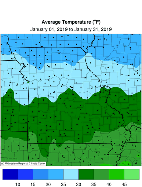
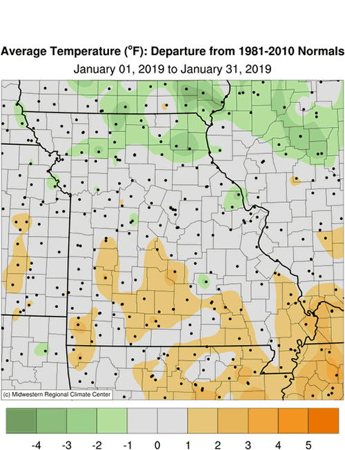
The recurring theme for winter, so far, has been "whiplash weather", from alternating periods of below normal temperatures to several mild weather days. Preliminary data indicate the average statewide temperature for January was 30.3°F, or 0.7 degrees above the long-term average. It was the ninth month out the past thirteen to average above normal, Figure 3, and followed the general trend toward milder Januaries over the past couple decades, Figure 4.
The cold air outbreak at the end of the month resulted in sub-zero temperatures across the northern two-thirds of Missouri, Figure 5. Some of the coldest temperatures occurred in far northern Missouri, where a deep snow blanket enhanced the cold, Table 1.
| January 2019 Minimum Daily Temperature (°F) | |||
| Station Name* | County | Min Temp (°F) | Date |
| Grant City 5WSW | Worth | -20 | 30 |
| Albany | Gentry | -19 | 30 |
| Bethany | Harrison | -19 | 31 |
| Green City 5N | Sullivan | -19 | 31 |
| Princeton | Mercer | -19 | 31 |
| Unionville | Putnam | -19 | 30 |
| *NWS Cooperative network and Missouri Mesonet | |||
| Table 1. | |||
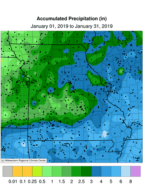
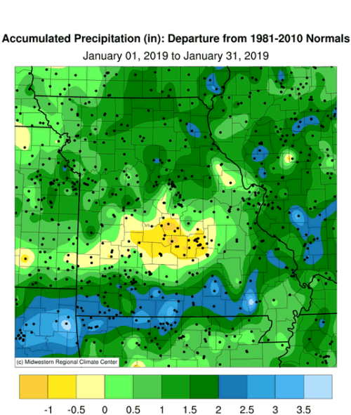
Preliminary precipitation data indicated a statewide average of 3.24 inches, a little more than 1-inch above the long-term average, and the wettest start to the year since 2013, Figure 6. It was the second consecutive month with above average precipitation, Figure 7.
Heaviest monthly precipitation was confined to central, east central and the southern quarter of Missouri where 3-4.5 inches were common. A few counties in far southern sections, especially southeastern Missouri, reported more than 5-inches for the month. Lighter amounts, ranging from 1-3 inches, were typical across northern, west central, and a small area in south central Missouri. Some of the lightest and heaviest monthly totals are listed in Table 2.
| January 2019 | |||
| Station Name* | County |
Rainfall (in.) | |
| Lightest | St. Joseph Airport | Buchanan | 0.77 |
| Burlington Junction 1NW | Nodaway | 1.24 | |
| Forest City 6.9N | Holt | 1.24 | |
| Grant City 0.5NE | Worth | 1.25 | |
| Lakeside | Miller | 1.27 | |
| Heaviest | Cape Girardeau 1.8SE | Cape Girardeau | 6.84 |
| Gainesville 6.2ENE | Ozark | 6.58 | |
| Ava 0.8NNW | Douglas | 6.48 | |
| Jackson | Cape Girardeau | 6.25 | |
| Scott City 0.9E | Scott | 5.74 | |
| *Precipitation gauges are from the NWS Cooperative Network or CoCoRaHS Network | |||
| Table 2. | |||
A historic snow event impacted Missouri during the weekend of January 11-13, when a slow moving storm system dropped moderate to heavy snow over 3-day period, Figures 8 and 9. The majority of snow fell steadily over a 48-hour period, and began as a cold rain during the mid-morning hours of January 11, mixing with snow by early afternoon, and turning to all snow as the afternoon progressed. Accumulating snow generally impacted the northern two-thirds of Missouri, with heaviest amounts reported across mid-Missouri, Table 3. The Columbia Regional Airport reported a 2-day total (Jan 11-12) of 16.2 inches, which was the third largest 2-day accumulation since records began in 1889. Only Feb 1-2, 2011 and Jan 18-19, 1995 were higher, with 17.7" and 19.7", respectively.
| January 11-13, 2019 Total Snowfall (in.) | |||
| Station Name* | County |
Snowfall (in.) | |
| Ashland 4.2E | Boone | 20.0 | |
| Harrisburg 5.9 SSE | Boone | 20.0 | |
| Centralia 1.5N | Boone | 20.0 | |
| Mexico 3.3SSW | Audrain | 19.0 | |
| Thompson 7.8SSW | Audrain | 19.0 | |
| Middletown 3.5SW | Montgomery | 19.0 | |
| Columbia 4.9NNW | Boone | 18.5 | |
| Hallsville 0.5ENE | Boone | 18.5 | |
| Boonville 0.5ESE | Cooper | 18.0 | |
| Columbia 0.9SSE | Boone | 17.3 | |
| *Precipitation gauges are from the NWS Cooperative Network or CoCoRaHS Network | |||
| Table 3. | |||
The snowfall had high water content, and fell during a period when winds were relatively light. Remarkable accumulations occurred on all surfaces, including trees, branches, shrubs, vehicles, buildings and residences, Figures 10-13. Even though the landscape was picturesque, the heavy snow load resulted in numerous downed tree limbs and power lines. The University of Missouri reported tree damage to a third of all trees on campus and as many as 100,000 people were without power in central Missouri at the height of the storm. Travel conditions were horrendous. The following is a situation report submitted by the National Weather Service office in St. Louis, MO:
"Many people reported evening commutes of 6 hours or more due to the persistent heavy snow which fell during rush hour. Some drivers were forced to stay in their vehicles for over 15 hours (Friday evening through Saturday) on I-44 due to hazardous road conditions and several road closures. The Missouri State Highway Patrol responded to nearly 4,000 calls for help, rescued nearly 1,800 stranded motorists, and recorded 878 crashes on interstates and highways. Fifty-seven people were injured and four died in those traffic accidents. Lambert St. Louis International Airport canceled 108 arriving flights and 101 departing flights during January 11-12."
The cold and snowy conditions translated to higher than usual energy consumption and hardship for outdoor workers, exposed livestock and pets. Some ranchers dealt with chopping ice for livestock due to frozen ponds. The �whiplash weather� this winter, and above average precipitation, resulted in several freeze-thaw cycles, muddy and icy conditions and plentiful potholes.
On the positive side, the wet weather eliminated any remaining vestige of drought in Missouri, according to the U.S. Drought Monitor, Figure 14.
Jump to:
- Figure 1
- Figure 2
- Figure 3
- Figure 4
- Figure 5
- Figure 6
- Figure 7
- Figure 8
- Figure 9
- Figure 10
- Figure 11
- Figure 12
- Figure 13
- Figure 14
- Figure 15
- Figure 16
- Figure 17
- Figure 18
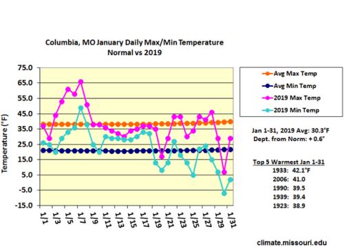
Figure 1.
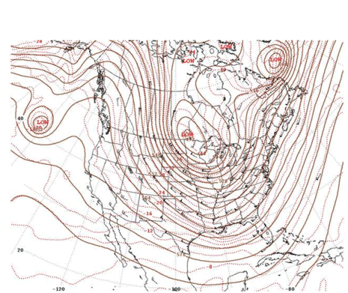
Figure 2. 500-Millibar Height Contours at 6:00 a.m. CST, January 29, 2019. Source: Daily Weather Maps
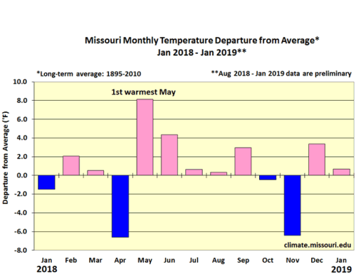
Figure 3.
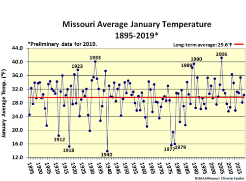
Figure 4.
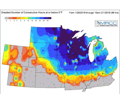
Figure 5.
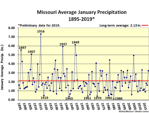
Figure 6.
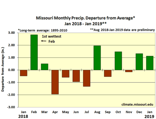
Figure 7.
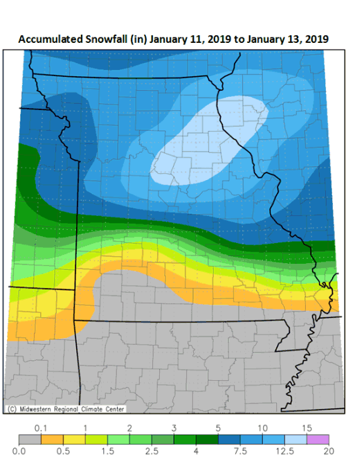
Figure 8.
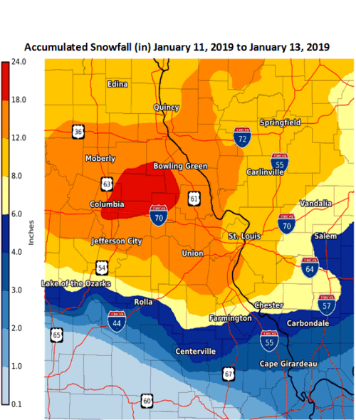
Figure 9. Source: NWS/NOAA.
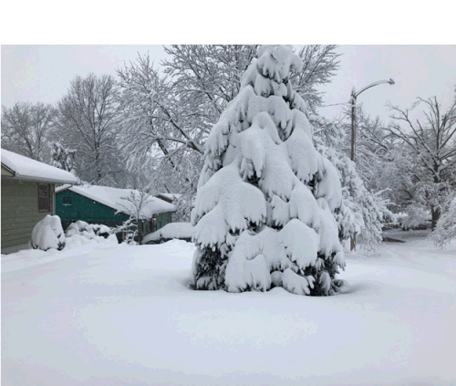
Figure 10. Columbia, Missouri January 12, 2019
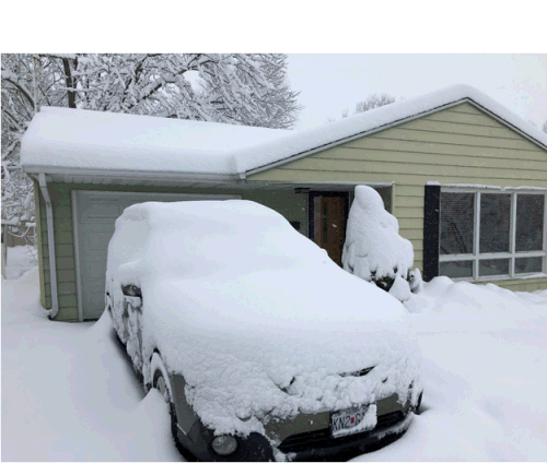
Figure 11. Columbia, Missouri, January 12, 2019
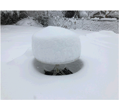
Figure 12. Columbia, Missouri, January 12, 2019
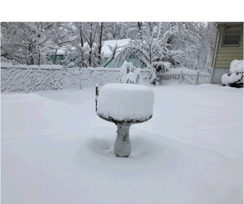
Figure 13. Columbia, Missouri, January 12, 2019
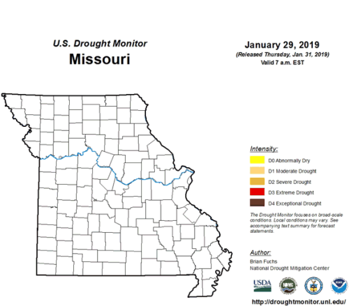
Figure 14.
Source: Pat Guinan, 573-882-5908