
January 2017 Weather and Its Impacts on Missouri
Pat Guinan
State Climatologist
Commercial Agriculture/University of Missouri Extension
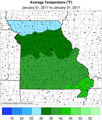
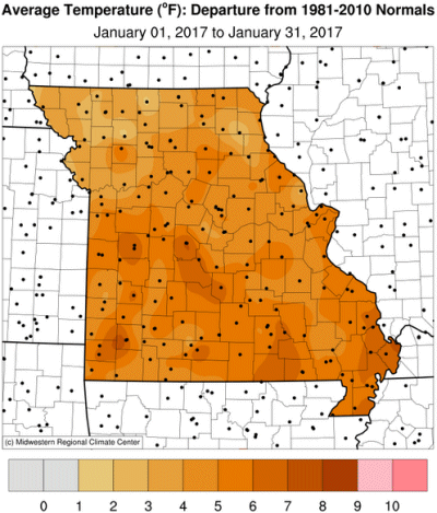
Roller coaster temperatures occurred during the first half of January in Missouri, but they transitioned to a stable and mild weather pattern during the latter half of the month, Figure 1. Preliminary data indicate the average statewide temperature for January was 34.7°, slightly more than 5 degrees above normal, Figure 2. The month followed the trend of mild Januaries over the past few decades, Figure 3.
Coldest conditions occurred early in the month when arctic air spilled into the region on January 4th and well below normal temperatures dominated for a few days, Table 1. With the exception of far southeastern Missouri, most locations dipped to near or slightly below zero for a day or two. Shortly thereafter, southerly flow on the backside of the retreating arctic high pressure system resulted in some of the warmest temperatures for the month, with several locations across the southern half of the state reporting temperatures in the 70s on January 11.
| January 2017 Minimum Daily Temperature | |||
| Location* | County | Min Temp (°F) | Date |
| Albany | Gentry | -14 | 6 |
| Richmond 3S | Ray | -12 | 6 |
| Kearney 3E | Clay | -11 | 7 |
| Bethany | Harrison | -9 | 7 |
| Tarkio #2 | Atchinson | -9 | 7 |
| * NWS Cooperative network and Missouri Mesonet | |||
| Table 1. | |||
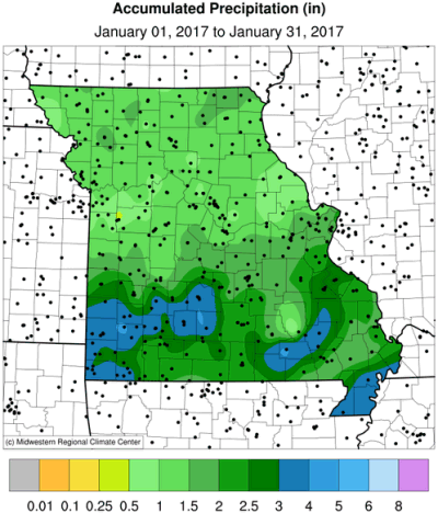
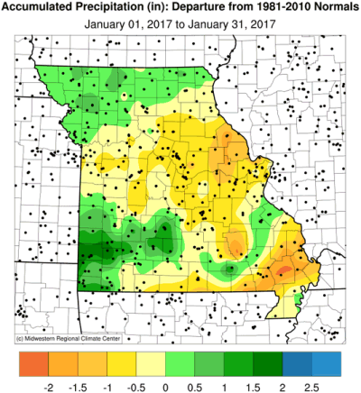
Precipitation was variable across the state with preliminary data indicating a statewide average just shy of 2-inches, slightly below normal. It was the fourth consecutive month with below normal precipitation, figure 4. Most of northern and central Missouri reported between 1-1.5 inches, with some pockets in east central and west central Missouri observing less than 1-inch. Totals ranging from 1.5 to 3-inches were common across southern Missouri. Several southwestern counties and far southeastern Missouri reported more than 3-inches for the month.
A freezing rain event on January 13-14 resulted in hazardous driving conditions across the state. Portions of southern Missouri reported 0.25-0.75" of ice accumulation resulting in downed tree branches and scattered power outages. The community of Waynesville, in Pulaski county, reported 0.75" of ice on January 14. Fortunately, warmer weather melted the ice a day or two later.
Little to no snowfall was reported during the month, which has been the theme, so far, for the 2016-17 winter season. Since November 1, most of the state has reported less than 4-inches of snow, Figure 5, well below the 3-month average, Figure 6.
The Drought Monitor map depicted abnormally dry conditions over much of Missouri by the end of January, with a couple pockets of moderate drought, Figure 7. The dryness was representative of below normal precipitation since October 1, where 4-month precipitation deficits have exceeded more than 3 inches in most locations, Figure 8.
Dryness impacts are few during the cold season in Missouri since vegetation is dormant and evaporative loss minimal. Currently, ponds around the state are generally full to a foot or so below full, field surfaces are damp and some ravines still have standing water in them. In general, dry winter conditions come without negative impacts in Missouri, whereas muddy weather can be challenging for livestock, off-road farming activities, and outdoor construction.
The concern is if precipitation remains below normal for the rest of winter, and we approach the spring growing season with dry conditions, we could see a quick decline into drought. Soil moisture reserves are not recharged and continued dryness will lead to additional soil moisture depletion and vegetative drought stress when spring arrives.
Jump to:
- Figure 1
- Figure 2
- Figure 3
- Figure 4
- Figure 5
- Figure 6
- Figure 7
- Figure 8
- Figure 9
- Figure 10
- Figure 11
- Figure 12
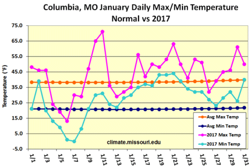
Figure 1.
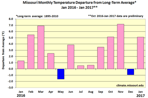
Figure 2.
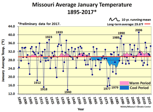
Figure 3.
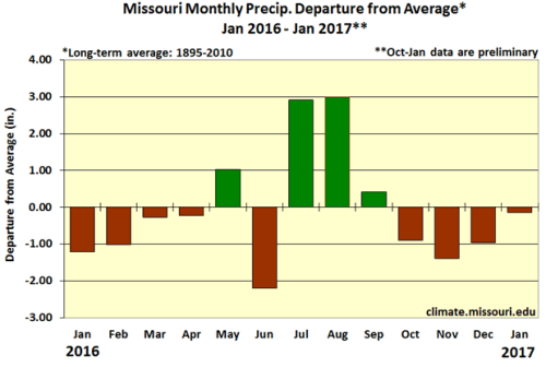
Figure 4.
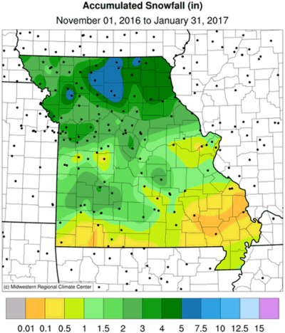
Figure 5.
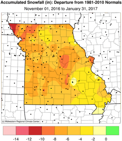
Figure 6.
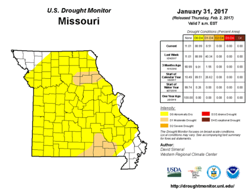
Figure 7.
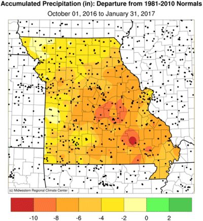
Figure 8.
Source: Pat Guinan, 573-882-5908