November 2024 Weather and Its Impacts on Missouri
Dr. Pat Guinan |
Dr. Zachary Leasor |
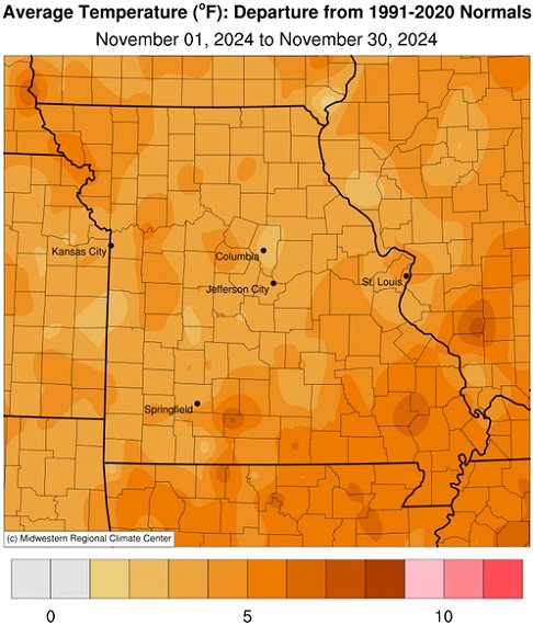
Unseasonably mild weather impacted Missouri during November with preliminary data indicating a statewide average temperature of 49.0°F, 5.4 degrees above the long-term average, and 11th warmest November on record, Figure 1. The first 2.5 weeks of the month were seasonably pleasant with high temperatures consistently reaching the 50's and 60's, Figure 2. It was the third consecutive month with above average temperatures, Figure 3, and the 4th warmest autumn (Sep-Oct-Nov) in 130 years, Figure 4. Eight out of the past eleven months in Missouri have been warmer than normal and the Jan-Nov period ranked as the 2nd warmest on record, only 2012 was warmer, Figure 5.
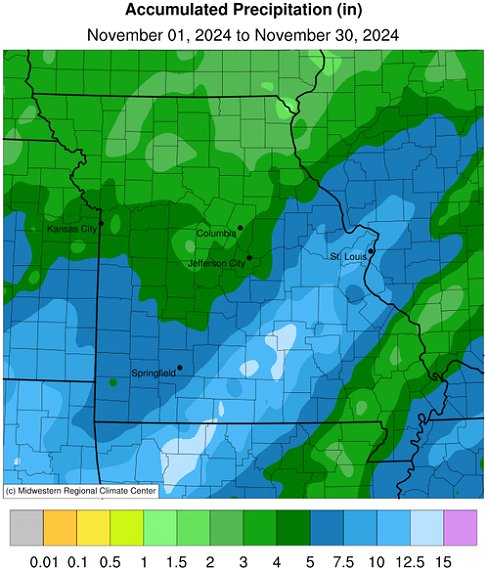
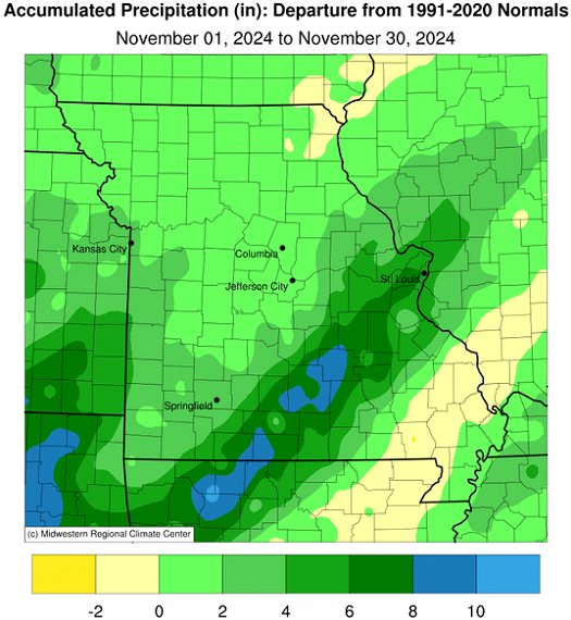
Preliminary rainfall data for November indicate a statewide average of 5.49 inches, well above the monthly long-term average of 2.91 inches. It was the 11th wettest November on record, Figure 6, and sixth above average month for the year, Figure 7. According to radar estimates, lightest precipitation occurred across northern and far southeastern Missouri where 2-4 inches were common. Heavier totals, generally 4-8 inches, impacted central and southern sections. Unusually high amounts were reported in an 80-mile wide corridor, extending from far south central Missouri northeastward into the St. Louis metropolitan area, Figure 8. Monthly accumulations inside the corridor ranged from 8-12+ inches. Some of the highest and lowest rainfall reports for November are listed in Table 1.
| Missouri High and Low Precipitation Extremes for November 2024 | |||
| Station Name* | County | Precipitation (in.) | |
| Heaviest | |||
| Mountain Grove 2N | Wright | 14.13 | |
| Salem 1.8NW | Dent | 13.85 | |
| Summersville 3.6S | Texas | 13.50 | |
| White Church 6NNE | Howell | 13.24 | |
| Wasola 5N | Douglas | 13.16 | |
| Dora 3SE | Ozark | 12.72 | |
| Steelville 7.3ESE | Crawford | 12.38 | |
| Lightest | |||
| Monticello 0.4SSW | Lewis | 2.00 | |
| Pattonsburg 6.9SW | DeKalb | 2.16 | |
| Memphis | Scotland | 2.28 | |
| Edina | Knox | 2.34 | |
| Utica 0.1ESE | Livingston | 2.56 | |
| Luray 2N | Clark | 2.60 | |
| Shelbyville 5.5NNW | Shelby | 2.63 | |
| *CoCoRaHS and National Weather Service Cooperative reports | |||
| Table 1. | |||
An extreme rainfall event impacted portions of south central and east central Missouri on November 4-5 where observers reported more than 10-inches across portions of Wright, Dent, Texas, Douglas, Ozark and Crawford Counties. Flash flooding was reported with 5 fatalities reported in the state as well as several water rescues. One fatality was reported in Iron County and two additional fatalities were reported in St. Louis County. Two poll workers died after their vehicle was swept off a highway in Wright County according to the Missouri State Highway Patrol. The National Weather Service office in St. Louis reported extreme and rapid rises along the Big, Black, Meramec, and St. Francis rivers. The upper Current River reached historic levels on November 5th according to the National Park Service.
All-time one-day and two-day state rainfall records for November were broken during the period. A National Weather Service cooperative observer located 2 miles north of Mountain Grove reported 9.83 inches on November 5th, breaking the previous state record of 8.10 inches at Clearwater Dam, in Wayne County, on November 15, 2005. The same observer in Mountain Grove reported a 2-day total of 12.50 inches on November 4-5, 2024, breaking the previous 2-day record at a cooperative station located 4 miles northwest of Warrensburg on November 16-17, 1928, when 9.74 inches were reported.
Severe weather was also reported on November 4th with preliminary surveys indicating 6 EF-0 tornadoes (65-85 mph) impacting the state, Figure 9. Only tree and property damage were reported.
A significant snow event at the end of the month impacted central Missouri with 1-4 inches falling near and along the I-70 corridor, from Kansas City to St. Louis, Figure 10. Hazardous driving conditions were reported.
As of November 26, 2024, the U.S. Drought Monitor indicated abnormally dry to moderate drought conditions impacting western and northeastern portions of Missouri, Figure 11.
The mild November weather translated to state, county, and consumer savings associated with lower heating demand. As of November 24th, the Missouri Agricultural Statistics Service reported 85% of the topsoil moisture supplies in adequate condition and 79% of the subsoil moisture supply as adequate. Soybean harvest was 95% complete, compared to the 5-year average of 95%. Winter wheat progressed to 96% planted compared to the 5-year average of 95%. Winter wheat was reported to be 82% emerged, 2 percentage points lower than the 5-year average, and 78% in good to excellent condition. The state reported 83% of its hay supplies and other roughages as adequate, and 89% of the stock water supplies adequate.
Jump to:
- Figure 1
- Figure 2
- Figure 3
- Figure 4
- Figure 5
- Figure 6
- Figure 7
- Figure 8
- Figure 9
- Figure 10
- Figure 11
- Figure 12
- Figure 13
- Figure 14
- Figure 15
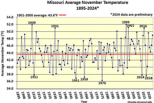
Figure 1.
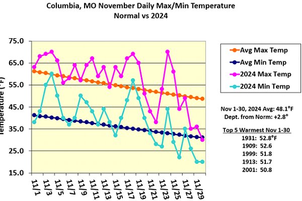
Figure 2.
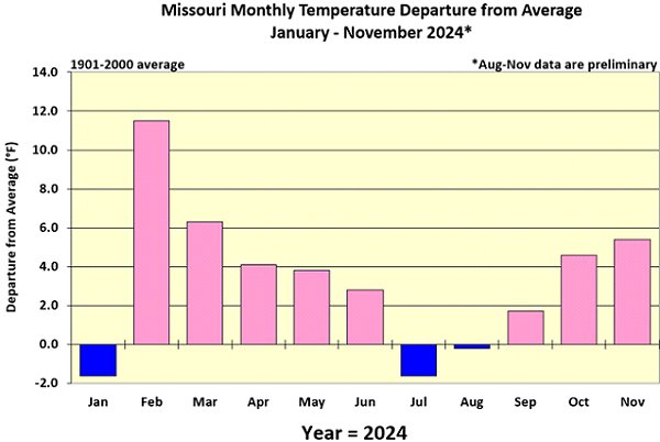
Figure 3.
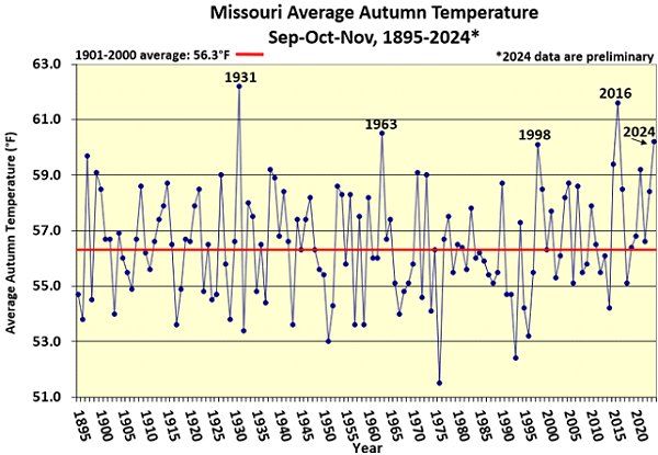
Figure 4.
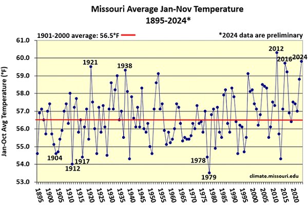
Figure 5.
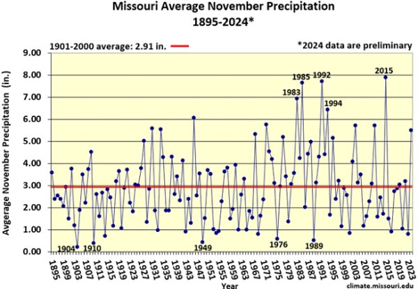
Figure 6.
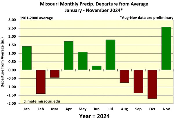
Figure 7.
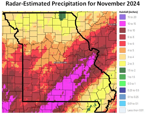
Figure 8.
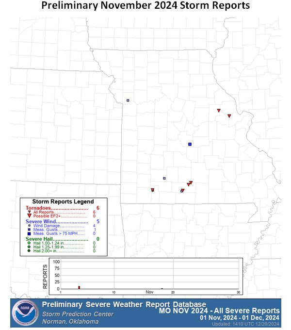
Figure 9.
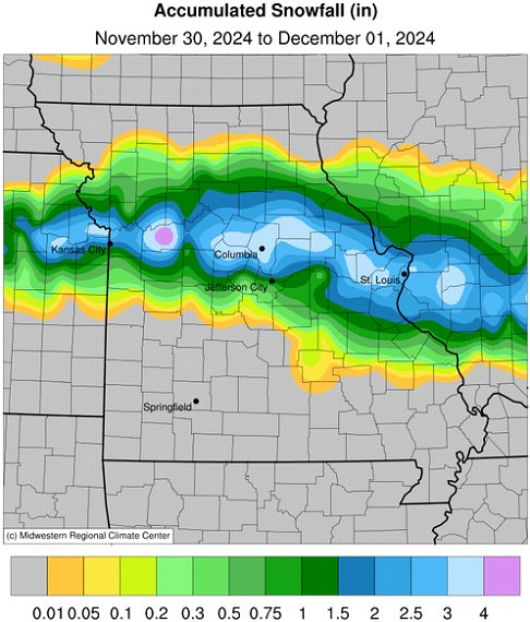
Figure 10.
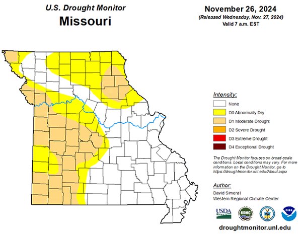
Figure 11.
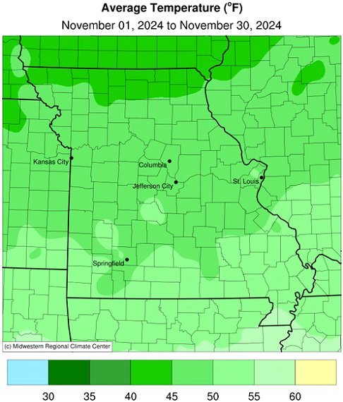
Source: Dr. Pat Guinan and Dr. Zack Leasor | 573-882-5908


