November 2017 Weather and Its Impacts on Missouri
Pat Guinan
State Climatologist
Commercial Agriculture/University of Missouri Extension
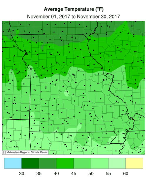
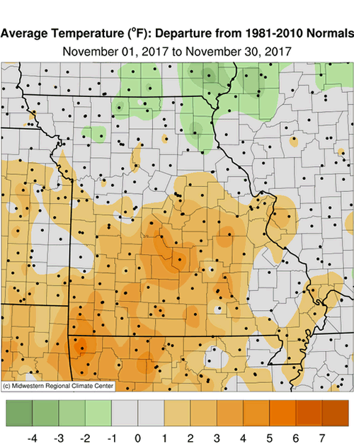
Mild fall weather continued through much of November for Missouri. Preliminary data indicates the statewide average temperature for the month was 45.8�F, 2 degrees above the long-term average. The mild November conditions have been the dominant trend over the past two decades, with only five Novembers averaging below normal since 1998, Figure 1. It was the 3rd consecutive warmer than average month, Figure 2, and 3rd consecutive mild autumn (Sep-Oct-Nov) for the Show Me State, Figure 3.
A nearby meandering jet stream led to changeable weather patterns and warm and cool periods during the first 3 weeks of the month. An unusual mild spell during the last week was the warmest period in November, Figure 4. The holiday period was particularly pleasant, with many locations climbing into the 70s the day after Thanksgiving. Record high temperatures for Nov 24th include St. Joseph, 75�F; Kirksville, 73�F; St. Louis, 74�F; Columbia, 74�F; Springfield, 74�; and Vichy-Rolla, 73�F. No widespread hard freezes during the first week of November extended peak fall colors into the month.
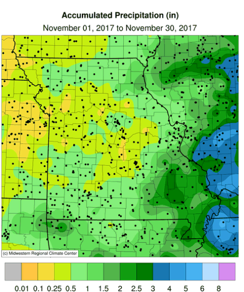
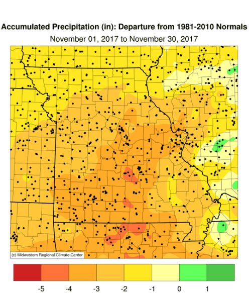
Dry conditions prevailed statewide in November with several sunny days, especially during the latter half of the month. Preliminary monthly precipitation data indicate a statewide average total of 0.92 inches, nearly 2-inches below the long-term average. It was the driest November in 15 years, Figure 5, and the sixth month in 2017 with below normal precipitation, Figure 6. The statewide average autumn total for Sep-Oct-Nov was 5.70 inches, 4.5 inches below the long-term average, or 56% of normal. It was Missouri�s driest fall since 1999, Figure 7.
Heaviest monthly totals occurred in far southeastern sections where 2 to 3 inches were common. Lightest amounts, less than 0.50 inches, were reported in several northwestern and west central counties and scattered areas in central and south central Missouri. Kansas City and Springfield reported their 4th driest November on record with 0.27� and 0.37�, respectively. Columbia Regional Airport reported 0.36�, which was the 7th driest November on record.
As of November 28, the Drought Monitor indicated moderate to severe drought impacting much of east central and southern Missouri. Abnormally dry conditions were affecting central and northeastern sections, Figure 8. The dry spell has been ongoing over parts of east central and southern Missouri for the past 6 months and deficits have exceeded a foot in some of the driest locations, Figure 9.
Impacts are already occurring and include some of the following, according to agricultural extension specialists in the region:
� Producers are feeding hay due to minimal fall grass growth and little to no hay cuttings; supply is still decent, mostly from a large carryover of hay from last year/winter.
� Some producers are moving cattle or hauling water because of low or empty ponds, or little to no flow in creeks and springs; many are saying it�s worse than 2012.
� Since many farmers are feeding hay earlier than usual, they are beginning to cull their herds to reduce the amount of animals that will need feed through the winter.
� Cattle are being lost from possible nitrate poisoning incidents in weeds
� Producers will likely feed lower quality hay and cows will be in poorer condition coming out of the winter, which may reduce future calf crop numbers.
� There have been failures of fall sown crops germinating and annuals such as oats, turnips, etc. have not produced well. New grass and legume seedlings are not looking good.
� Fall seeded perennials in some cases germinated then died or didn�t germinate until mid to late October, leaving them immature going into the winter.
� Wheat is not germinating properly.
As of November 26th, the Missouri Agricultural Statistics Service reported, statewide, that 67% of the topsoil moisture supplies were in adequate condition and 67% of the subsoil moisture supply as adequate. However, three crop reporting districts reported topsoil moisture supplies mostly in in short to very short condition, including East Central-59%, Southwest-81% and South Central-64%. Similarly, subsoil moisture supplies reported short to very short were East Central-65%, Southwest-44% and South Central-67%.
Winter wheat was reported to be 83% emerged, 1 percentage point lower than the 5-year average, and 57% in good to excellent condition. All crop reporting districts reported the majority of their hay supplies and other roughages as adequate. The majority of stock water supplies were mostly adequate statewide, with the exception of the east central district where 50% of the supplies were reported short to very short. The south central district was not far behind, reporting 47% of the stock water supplies short to very short.
The extended period of dryness across east central and much of southern Missouri has resulted in numerous agricultural and hydrological impacts and conditions will continue to deteriorate if significant precipitation events do not return this winter. Winter precipitation (Dec-Jan-Feb) for south central and southeast Missouri is typically a good time of year to bring recharge for depleted water resources. Figure 10 shows over the past 30 years, 8-12 inches are typical for the Dec-Feb period, with an increasing gradient as you move southeastward through the state.
Jump to:
- Figure 1
- Figure 2
- Figure 3
- Figure 4
- Figure 5
- Figure 6
- Figure 7
- Figure 8
- Figure 9
- Figure 10
- Figure 11
- Figure 12
- Figure 13
- Figure 14
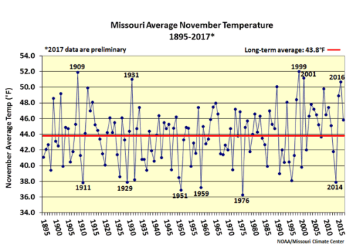
Figure 1.
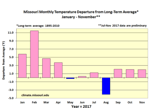
Figure 2.
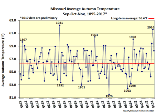
Figure 3.
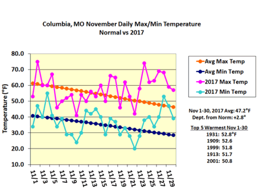
Figure 4.
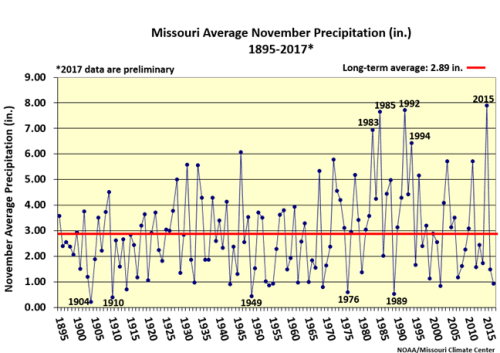
Figure 5.
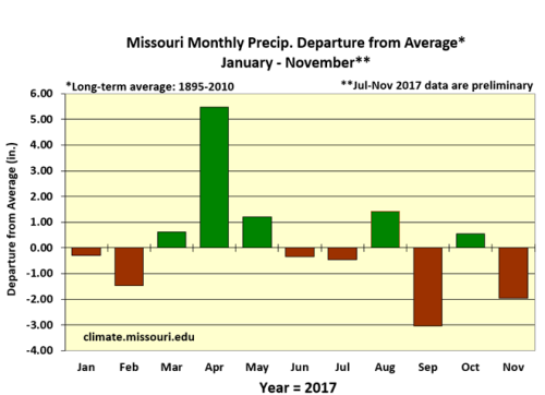
Figure 6.
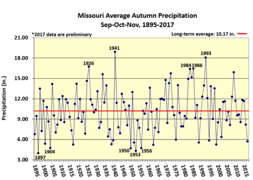
Figure 7.
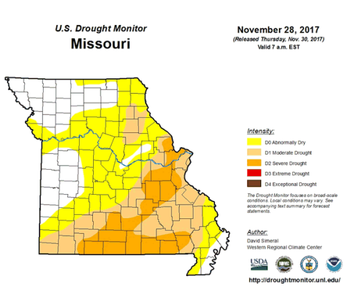
Figure 8.
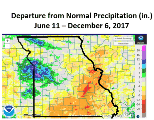
Figure 9. NOAA Radar Precipitation Departure Estimates
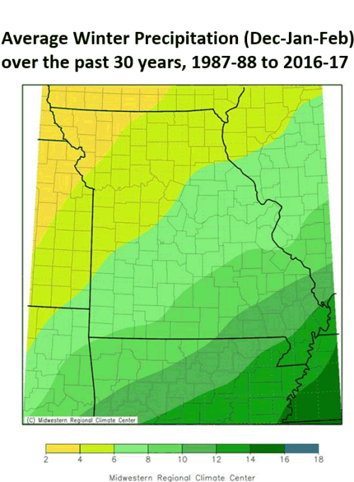
Figure 10.
Source: Pat Guinan, 573-882-5908


