November 2012 Weather and Its Impacts on Missouri
Pat Guinan
State Climatologist
Commercial Agriculture/University of Missouri Extension
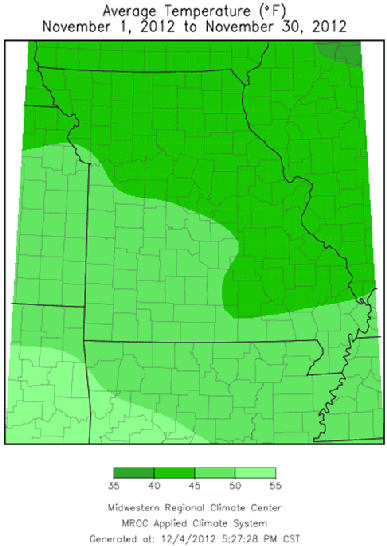
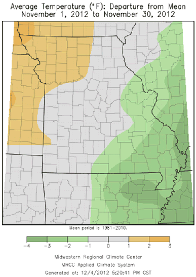
Seasonable temperatures and dry weather prevailed across the Show Me State in November. Preliminary data indicates the average statewide temperature was just shy of 45°F, or less than one degree above normal for the month. Regionally, northwestern sections averaged 1-2 degrees above normal for the month, whereas southeastern portions averaged 1-2.5 degrees below normal. The majority of days witnessed high temperatures in the 50's and 60's and low temperatures in the 30's and 40's. Coldest temperatures occurred for a few days after Thanksgiving, when minimum temperatures dropped to the teens and lower 20's across many locations. Lowest monthly temperatures in the Bootheel dropped only to the mid 20's.
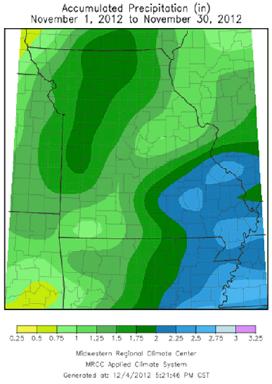
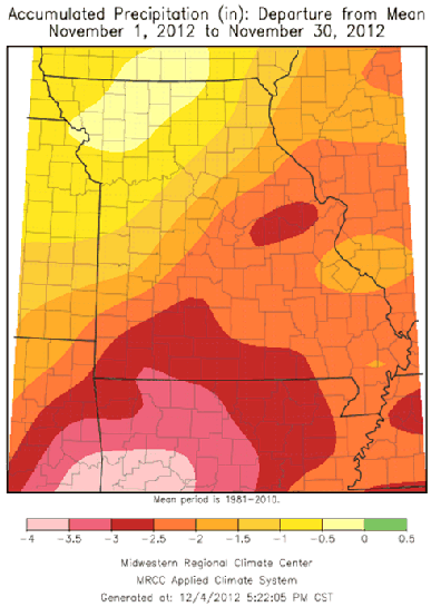
Precipitation was limited statewide, and rain events were few and far between during the month. Preliminary data indicate an average statewide total of 1.65 inches, or about 1.25 inches below normal. Heaviest monthly totals were confined to southeastern Missouri where 2-2.5 inches were common. A 100-mile wide corridor of lighter monthly totals, less than 1-inch, were reported from around Springfield, MO, in southwestern sections, to northwest of St. Louis, in east central Missouri. A CoCoRaHS observer residing near Vienna, MO, in Maries County, reported only 0.13" for the month.
There was one widespread and significant rain event to affect the state, occurring on the 11th of the month. Most locations received 0.75-1.50 inches of rain during the event.
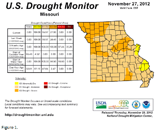
Drought continued to impact Missouri by the end of November, with more than 95% of the state experiencing moderate to severe drought according to the Drought Monitor map, Figure 1. Surface water and ground water supplies were still running well below normal despite some improvement in September and October. January through November precipitation deficits exceeded 10 inches in many Missouri locations, and it ranked as the driest January through November period in more than 30 years, or since 1980, Figure 2.
Winter is typically the dry season in Missouri and it is unlikely surface and ground water supplies will fully recover for the start of next year's growing season, especially across northern and central sections. The highest likelihood for hydrological drought to carry over into next year exists across northwestern Missouri, where year-end precipitation deficits exceed a foot and only 3-4 inches generally falls between December and February. Better chances for drought recovery will exist over southern sections where 7-12 inches typically fall from December to February.