
Missouri 2021 Climate Summary
Pat Guinan, MU Extension/State Climatologist
A wide variety of weather conditions were experienced by Missourians in 2021, from extreme February cold to record December warmth, from summer floods to fall drought, and winter tornadoes. Despite these erratic weather extremes, the Show Me State, overall, experienced a favorable growing season in 2021.
The year started off with alternating periods of seasonably mild weather followed by slightly cooler than average conditions. More than half the days in January were overcast, which kept the majority of overnight minimum temperatures elevated and above normal throughout the month. Official climate data indicate the average statewide temperature for January was 33.6°F, or 4.2 degrees above the long-term average (1901-2000), and follows the general trend of mild Januaries over the past couple decades. The coldest weather occurred toward the end of the month when the northern half of the state dropped to single digits and lower.
An unsettled January weather pattern impacted Missouri with significant precipitation events bookending the month. Precipitation data indicate a statewide average of 3.33 inches, or 1.24 inches above the long-term average (1901-2000). There were a few significant precipitation events impacting the state during January with the largest ones occurring during the beginning and end of the month. Some snow and ice events also occurred with heaviest monthly snow totals impacting portions of far northern Missouri where 7.5 to 12 inches were common. The heaviest monthly snowfall total came from the northwestern tip of Missouri where a CoCoRaHS observer from Nodaway County reported 13.5 inches.
After what was appearing to be another mild winter for Missouri, Mother Nature had a different plan for February. Early in February, the polar vortex migrated from near the North Pole to southern Canada and the north central U.S. bringing exceptionally cold temperatures and wind chills to the central U.S., from North Dakota to Texas. Temperature departures in Missouri for the 2-week period, February 6-19, 2021, averaged more than 20 degrees below normal with a statewide average temperature of 10.2°F. The last time a colder 2-week period occurred in Missouri was more than 30 years ago, Dec 11-24, 1989.
The core of the coldest air impacted western and northern Missouri where a fresh snowpack, clear skies and calm conditions resulted in an extremely cold morning. Two locations in northwestern Missouri, Corning (Atchison Co.) and Smithville Lake (Clay Co.) reported morning low temperatures of -26°F on the morning of the February 16th.
Climate data indicate a statewide average temperature of 24.4°F, or 9.4 degrees below the long-term average. It was the coldest February since 1979 and ranked as the 9th coldest February on record.
February precipitation data indicated a statewide average monthly total of 1.15 inches, or 0.87 inches below the long-term average. Lightest monthly totals were generally between 0.5-1.0" and fell over the western half of the state. The precipitation gradient increased heading eastward and southeastward through the rest of the Missouri, ranging from 1-3 inches. Heaviest totals were in the Bootheel, from 3-4 inches.
The cold February weather translated to most precipitation events falling in the form of snow, and above normal snowfall reported statewide, ranging from 6-14 inches for the month. A CoCoRaHS observer just south of Kirksville reported 15.9 inches.
February impacts were numerous with the anomalously cold weather not seen in more than a generation. Energy consumption was unusually high and reflected in consumer's home heating bills. Cold stress on outdoor workers, exposed livestock and pets was unrelenting, especially with wind chills dropping to -30°F. Ranchers were challenged with keeping newborn calves warm, feeding hay and routinely chopping ice-covered ponds for water. Dock damage due to freezing and thawing of ice on lakes was also reported and the extended period of cold weather contributed toward a deeper frost line than usual in the soil with numerous instances of frozen and broken pipes reported.
Mild weather dominated the Show Me state in March, especially during the first and last 10 days of the month. The two periods were separated by a cool, cloudy and wet conditions during the middle of March. The statewide average temperature for the month was 49.9°F, or 6.3 degrees above the long-term average.
March precipitation was above normal statewide with only a handful of counties in the north central and northeastern Missouri reporting near normal precipitation. Climate data indicate the average statewide March total was 5.26 inches, or 2.05 inches above the long-term average. The wet conditions limited spring fieldwork activity across the state.
Roller coaster temperatures characterized April with weeks 1 and 4 averaging above normal and cooler conditions for weeks 2 and 3. Official data indicate a statewide average temperature of 54.2 °F, or 0.3 degrees below the baseline period mean (1901-2000). Three out of the past four Aprils have been cooler than average.
A cold weather event on April 21-22 brought sub-freezing temperatures to the state, including record low temperatures. Freeze damage was reported to vegetation in vulnerable growth stages, including some early planted corn in southeastern Missouri, as well as some fruit crops, ornamentals and annuals. Lodging of forage crops was also reported.
April precipitation was above average with a statewide average total of 4.36 inches, or 0.39 inches above the baseline period mean (1901-2000). Mostly wet conditions impacted Missouri for the first quarter of the year with 3 out the past 4 months reporting above average precipitation.
An unusual late spring snow event impacted Missouri on April 20-21. Accumulations were generally 1-5 inches statewide, occurring mostly on elevated and grassy surfaces.
According to the Missouri Agricultural Statistics Service, for the week ending April 25, corn planting was 23% complete, 21 percentage points behind the 5-year average. Stock water supplies were reported mostly adequate at 94% with 81% of the hay supplies and other roughages adequate and 6% surplus. The majority of pastures, 67%, were in good condition and 27% in fair condition. Topsoil moisture supplies were mostly adequate (82%) to surplus (17%) statewide. Subsoil moisture supplies were mostly adequate (87%) to surplus (12%).
Cool was the rule in Missouri during May, especially with maximum daily temperatures remaining below average. The statewide average temperature was 62.3°F, or 1.9° below the long-term average. The cool conditions were similar to May weather the previous year and it was the second consecutive cool month and third below average month for 2021.
May precipitation was variable across Missouri, ranging from 2-3 inches in some east central counties to more than 10-inches in parts of west central and southwestern Missouri. The statewide average total of 4.99 inches was 0.33 inches above the long-term average. The wet conditions followed the trend over the past few decades. Since 1990, 22 Mays, or 69% of them, have been wetter than average. Four out the five wettest Mays on record have occurred since 1990.
There were several May days in 2021 with cloudy, showery weather, especially during the latter half of the month. Several locations experienced measurable rainfall and overcast conditions for more than half the days in May.
According to the Missouri Agricultural Statistics Service, as of May 30, 2021, 92% of the corn and 49% of the soybean crop had been planted; the 5-year average is 91% and 53%, respectively. The cool, cloudy weather generally benefited pastures with 71% of them reported to be in good condition and 6% excellent. Hay supplies and other roughages were listed at 85% adequate and 4% surplus. Stock water supplies were reported mostly adequate at 87% and 13% surplus. Topsoil moisture supplies were mostly adequate (57%) to surplus (42%) statewide. Subsoil moisture supplies were mostly adequate (74%) to surplus (25%).
The statewide average monthly temperature for June was 74.8°F, or 1.8 degrees above the baseline average (1901-2000). The warmer than average temperatures followed the trend over the past several years, where only one June since 2005 has been below average.
Dry and hot conditions emerged during the first few weeks of June and producers were concerned since critical corn growth stages were approaching. A pattern change, however, during the third week shifted concerns from impending drought to flooding. The majority of rainfall occurred during the last 12 days of June and a few locations reported their wettest June in decades. Columbia Regional Airport reported 0.10" between June 1-19, but received 10.85 inches for the month, making it the 2nd wettest June since 1890 and wettest June since 1928 when 14.86 inches was reported.
June rainfall was above average statewide, but variable across Missouri, ranging from 10-15+ inches in parts of northwestern and central Missouri to less than 2-inches over portions of southern Missouri, according to radar estimates. The statewide average rainfall total was 5.98 inches, 0.96 inches above the baseline average (1901-2000).
The extraordinary amount of rainfall that fell over parts of the state during the last 12 days of June resulted in thousands of acres of flooded low-lying fields and bottomlands. Nitrogen deficiencies in corn were also reported. Alternatively, pastures had greened up nicely with the cooler temperatures and abundant rainfall.
The wetter conditions toward the end of June resulted in no drought for the Show Me State, according to the U.S. Drought Monitor. There were a couple areas showing abnormally dry conditions, including a few northwestern counties bordering Iowa and a thin corridor in southeastern Missouri, extending from Ste. Genevieve and Perry Counties southwestward to parts of Carter and Shannon Counties.
According to the Missouri Agricultural Statistics Service, for the week ending June 27, 2% of the corn was silking compared to a 5-year average of 15%. Soybean was 96% planted, compared to a 5-year average of 91%. Topsoil moisture supplies were rated 86% adequate to surplus and subsoil moisture was rated at 91% adequate to surplus. Corn was rated mostly good to excellent at 58% and soybean was reported at 57% good to excellent. Pasture conditions were mostly good to excellent at 72%. The majority of hay supplies and roughages were adequate at 81%. Stock water supplies were reported to be in adequate (85%) or surplus (12%) condition.
Seasonably cool temperatures impacted Missouri in July with data indicating a statewide average temperature of 76.6°F, or 1.1° below the long-term average. Daily maximum temperatures for July were mostly below average, generally climbing into the 80s. There was a period of hotter weather during the last week of the month when temperatures reached into the 90's. With one exception, there was no triple digit reported statewide during the entire month. A cooperative observer located 2 miles west of Cosby, MO, in Andrew County, reported a high temperature of 100°F on July 30th.
Minimum July temperatures were mostly in the 60's with some 70's reported toward the end of the month. There were more above average minimum temperature days than maximum temperature days due, in part, to above average dew point temperature. High dew points elevate minimum air temperatures while suppressing maximum temperatures. The high July dew points this year followed the trend Missouri has experienced over the past few decades.
The statewide average July rainfall total was 4.86 inches, or 1.15 inches above the long-term average. It was the fifth consecutive month with above average precipitation.
According to radar-estimates, heaviest July rainfall occurred over portions of northeastern and southeastern Missouri where 5-8 inches were common. A few areas reported more than 10-inches for the month. Driest conditions were across parts of northwestern and west central Missouri and a few isolated pockets in southern sections.
According to the Missouri Agricultural Statistics Service report for the week ending July 25, 2021, 10% of the state reported topsoil moisture supplies in short to very short condition with 84% of the state reporting topsoil moisture in adequate condition. Statewide subsoil condition was reported 5% short to very short, and 89% adequate. Corn, soybean and pasture conditions were reported at 8%, 9%, and 3% in poor to very poor condition, respectively. The majority of corn and soybean were reported in good to excellent condition at 66% and 61%, respectively. The majority of pasture was in good to excellent condition at 75%. The majority of hay and other roughages were adequate to surplus (93%), as well as stock water supplies (97%).
All of Missouri was "drought-free", according to the U.S. Drought Monitor, released on July 29, 2021. There was a small area of abnormally dry conditions reported in southeastern Missouri, impacting some southeastern Ozarks counties.
Above average daily August temperatures impacted Missouri with a statewide average temperature of 77.4°F, or 1.4° above the long-term average. It was the hottest August in a decade. Below average temperatures occurred during the first week of August and were followed by warmer than average conditions for much of the rest of the month, including several days with high temperatures in the 90s and lows in the upper 60s and lower 70s. Most locations, again, reported no triple-digit heat for the month.
Daily summer temperatures in 2021 reflected the overall trend of the past few decades, with no prolonged periods of extreme high temperatures. Mean summer temperature data (Jun-Jul-Aug) indicate slightly above normal conditions in 2021. The statewide average summer temperature was 76.3°F, 0.8° above the long-term average. Summer weather patterns over the past several decades indicate little change in maximum temperature trends, whereas minimum summer temperatures have been warming. This phenomenon is primarily due to above average summer dew point temperatures in Missouri.
Drier than average weather impacted Missouri in August with a statewide average of 2.99 inches, 0.72 inches below the long-term average. Typical of the summer season, August rainfall was highly variable, ranging from less than 1-inch to over 11-inches, according to rain gauge observations. Most areas received below average rainfall. Radar estimates indicated pockets of more than 5-inches in parts of the state but most locations received less than 3-inches.
The U.S. Drought Monitor map, for the week of August 31, 2021, indicated small areas of abnormally dry conditions impacting parts of central, southwestern and southeastern Missouri.
According to the Missouri Agricultural Statistics Service report for the week ending August 29, 2021, 67% of the state reported topsoil moisture supplies in adequate condition with 2% surplus, whereas 27% of Missouri reported short topsoil moisture supply and 4% very short. Subsoil moisture supplies were reported 74% adequate and 2% in surplus condition compared to 21% of the state reporting subsoil moisture supplies short and 3% very short. Corn was reported 63% in good to excellent condition compared to 77% last year. Soybean was reported 59% in good to excellent condition compared to 75% last year. Pastures were rated at 60% in good to excellent condition compared to 55% last year. Hay and other roughages were 91% adequate to surplus compared to 87% last year. Stock water supplies were 89% adequate and 11% short to very short.
Summerlike weather continued into September with above average daily temperatures for most of the month. The statewide average September temperature of 71.6 °F was 3.4 degrees above the long-term average. The mild month followed the trend over the past decade with only 3 out of the past 10 Septembers being cooler than average
Dry conditions impacted most of Missouri in September with rainfall data indicating a statewide average of 2.35 inches, 1.75 inches below the long-term average. It was the second consecutive dry month with an August-September statewide average rainfall total of 5.34 inches, 2.47 inches below average, and the driest August-September period since 1999.
September rainfall totals were variable across Missouri with radar-estimates indicating highest amounts in parts of west central and southeastern Missouri and a driest conditions across portions of northern Missouri.
The U.S. Drought Monitor map for September 28, 2021 showed over half of Missouri experiencing abnormally dry conditions to moderate drought. Driest conditions were localized and impacting portions of southern Missouri.
According to the Missouri Agricultural Statistics Service, as of September 26, 2021, the majority of the corn crop was in good to excellent condition at 54% and 13%, respectively. Remaining corn conditions this year were 24% fair, 7% poor and 2% very poor. Corn harvest was on pace with the 5-year average at 34%. The majority of the soybean crop this year was also reported in good (56%) to excellent (8%) condition compared to 61% good and 20% excellent at the same time last year.
The majority of hay and roughages were adequate (85%) to surplus (5%) this year with 8% short and 2% very short. Stock water supplies were mostly adequate at 82%, with 15% short and 3% very short. The majority of pastures were reported in fair (41%) to good (40%) condition with 3% in excellent condition and 16% in poor or very poor condition.
The majority of topsoil moisture conditions were 52% adequate and 0% surplus while 40% were reported short and 8% very short. The majority of subsoil moisture conditions were also reported to be adequate (64%) to surplus (0%) with 31% short and 5% very short.
The statewide average October temperature was 60.5°F, or 3.5° above the long-term average. It was the warmest October since 2016. It was also the sixth above average month for the year and third consecutive month with above average temperatures.
Warm conditions dominated the first three weeks of October with high temperatures on many days reaching the 70s. Most of Missouri typically experiences its first fall freeze in October, but this year only a handful of locations in northwestern Missouri and the eastern Ozarks reported temperatures =32°F. Fall freezes occurring later than usual has been the trend over the past couple decades.
A wetter pattern returned in October with a statewide average precipitation total of 5.86 inches, or 2.67 inches above the long-term average. It was the wettest October since 2014 and ranked as the 9th wettest October on record.
According to radar estimates, most locations reported more than 5-inches for October with scattered pockets of 3-5 inches elsewhere. Lightest totals occurred in east central Missouri, around the St. Louis metropolitan area. The highest mean county rainfall estimate for the state was in Mercer County with 9.87 inches. St. Louis County and St. Charles County both reported the lowest total of 3.33 inches.
Occasional wet periods in October limited opportunities for crop dry-down and fieldwork activity, but favorable September weather had given producers a head start on harvest. According to the Missouri Agricultural Statistics Service, for the week ending October 31, corn and soybean harvest was 86% and 59% complete, respectively; 4 percentage points ahead of the 5-year average for corn and 2% points behind the 5-year average for soybean. The majority of topsoil and subsoil moisture conditions were reported adequate at 80% and 83%, respectively. Hay supplies were mostly adequate (87%) to surplus (4%) with only 8% reported short to 1% very short. Stock water supplies were mostly adequate (92%).
Wet and warm October conditions, and no hard freezes, mitigated livestock winter feed supply concerns with robust cool season grass growth reported. The U.S. Drought Monitor also indicated improving conditions by the end of the month, with only small residual pockets of dryness impacting the Show Me State.
Seasonably mild weather occurred during November with data indicating a statewide average temperature of 45.5°F, 1.9 degrees above the long-term average. Typical daytime highs for the month were in the 50s and 60s with lows in the 30's and 40's. There were no extended periods of cold extremes. It was the warmest autumn (Sep-Oct-Nov) since 2016 and ranked as the 7th warmest autumn on record for Missouri.
Precipitation data for November indicate a statewide average total of 1.05 inches, or 1.86 inches below the monthly long-term average of 2.91 inches. It was the third month since August with below average precipitation and the driest autumn since 2017.
Heaviest monthly totals occurred over parts of northwestern, west central and southern Missouri where 1-2.5 inches were common. Lighter amounts, generally less than 1-inch, were reported across the rest of the state. With the exception of a thin corridor in northwestern Missouri, rainfall was below normal statewide. Winter weather and severe storm events were non-existent in November, but there were vibrant fall colors and beautiful sunsets during the month.
By the end of November, the U.S. Drought Monitor indicated abnormally dry conditions impacting more than 1/3 of Missouri, especially across the eastern half of the state. A small area of moderate drought was also noted over southeastern sections. The drier conditions provided numerous opportunities for fieldwork activity and outdoor construction projects.
As of November 28th, the Missouri Agricultural Statistics Service reported 88% of the topsoil moisture supplies in adequate condition and 85% of the subsoil moisture supply as adequate. Soybean harvest was 95% complete, compared to the 5-year average of 95%. Winter wheat progressed to 94% planted compared to the 5-year average of 94%. Winter wheat was reported to be 86% emerged, 5 percentage points higher than the 5-year average, and 62% in good to excellent condition. The state reported 87% of its hay supplies and other roughages as adequate, and 95% of the stock water supplies adequate.
Unusually mild conditions dominated Missouri during the final month of the year. Preliminary data indicated an average statewide December temperature of 44.3°F, or 11.3° above the long-term average. It was Missouri's warmest December in the past 127 years (1895-2021) and surpassed the previous December record set in 2015.
December precipitation was variable and generally increased from northwest to southeast. Preliminary data indicated a statewide monthly average of 2.17 inches, or 0.14 inches below the long-term average. Much of northern Missouri received less than 1-inch, with several northwestern counties reporting less than 0.50 inches. West central sections reported 0.5-1.5 inches, with much of central, east central and far southwestern Missouri receiving 1.5-2.5 inches. Heavier totals ranged from 2.5 to 5-inches across southern Missouri and increased along a gradient generally southeast of I-44.
No winter storms were reported in December, but two unusual severe storm outbreaks impacted the Show Me State during the month.
The first was a deadly late season multi-state tornado outbreak on December 10-11 impacting Arkansas, Missouri, Illinois, Tennessee and Kentucky. National Weather Service surveys documented six tornadoes in Missouri during the evening of December 10th, with two fatalities. A long-track EF4 tornado crossed the Missouri Bootheel from Arkansas and tore through Dunklin and Pemiscot Counties. The tornado path was reported to be just over a mile wide in places with estimated peak winds at 170 mph. Numerous homes were damaged or destroyed and one fatality was reported in Pemiscot Co., near the community of Braggadocio. Another deadly tornado, with estimated peak winds of 165 mph, impacted St. Charles and St. Louis Counties, in east central Missouri. The tornado destroyed a couple homes near the community of Defiance where one fatality was reported.
The second outbreak occurred on December 15th when an intense low pressure system in Kansas initiated a squall line of severe thunderstorms and tornadoes that swept through portions of Kansas, Nebraska, Missouri, Iowa, Minnesota and Wisconsin. The magnitude and intensity of the event fit the criteria for a derecho - where wind damage extended more than 250 miles and was accompanied by wind gusts of at least 58 mph. This was the first December derecho ever documented for the United States.
The mild late fall/early winter weather translated to state, county, and consumer savings associated with lower heating demand as well as less stressful conditions for outdoor workers, livestock and pets.
For the year, Missouri experienced 8 months with above average temperatures and 4 months with cooler than average conditions. Preliminary data indicated an annual statewide average temperature of 56.3°, 1.8° above the long-term average. Nineteen out of the past 24 years have been warmer than average, Figure 1. The statewide average annual precipitation total was 43.94 inches, 3.44 inches above the long-term average, Figure 2.
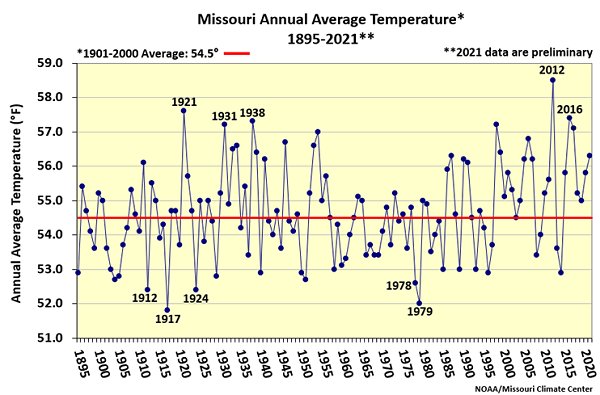
Figure 1.
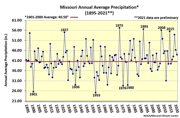
Figure 2.
Source: Pat Guinan, 573-882-5908