
July 2022 Weather and Its Impacts on Missouri
Pat Guinan
State Climatologist
University of Missouri Extension
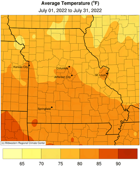
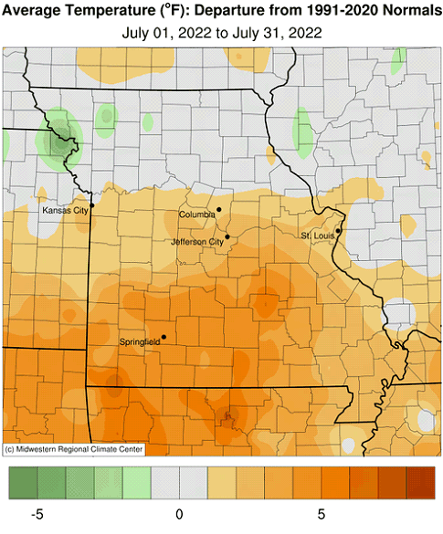
Above average temperatures impacted Missouri in July, especially across the southern half of the state, where dry conditions prevailed. Preliminary data indicated a statewide average temperature of 79.7°F, or 2.0° above the long-term average. It was the hottest July in a decade, Figure 1, and third consecutive warmer than average month for the year, Figure 2. Maximum July temperatures reached the mid 90's or higher for several days in central and southern sections, Figure 3. Many central and southern locations reported triple-digit heat for the month, especially during the latter half of July. Some of the highest maximum temperatures for July are shown in Table 1.
| MISSOURI TEMPERATURE JULY 2022 | |||
| Station Name* | County | Highest Max Temp (°F) | Date |
| Anderson 3W | McDonald | 108 | 27 |
| Washburn 5W | Barry | 108 | 27 |
| Joplin Regional AP | Jasper | 107 | 26 |
| Ozark Beach | Taney | 107 | 27 |
| Carr Creek | Shannon | 107 | 16 |
| Salem | Dent | 107 | 25 |
| Stockton Dam | Cedar | 106 | 27 |
| Neshso | Newton | 106 | 21 |
| Big Spring | Carter | 106 | 23 |
| Round Spring 2SW | Shannon | 106 | 27 |
| *NWS Cooperative Network | |||
| Table 1. | |||
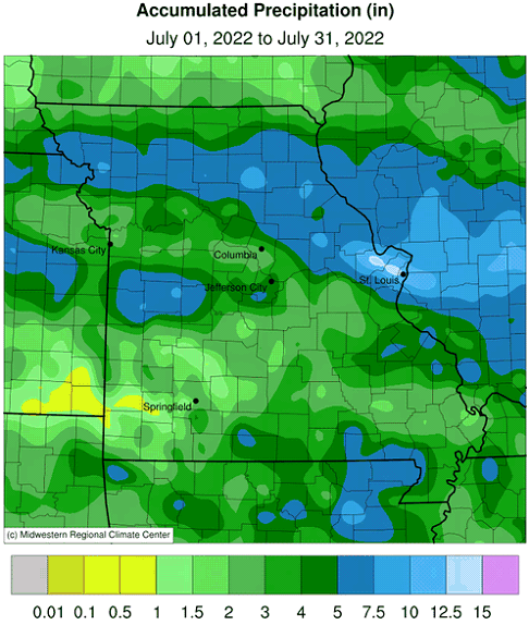
Preliminary data indicate the statewide average rainfall total was 3.95 inches, or 0.24 inches above the long-term average, Figure 4. It was the driest July since 2018. Five out the past seven months have been wetter than average this year, Figure 5.
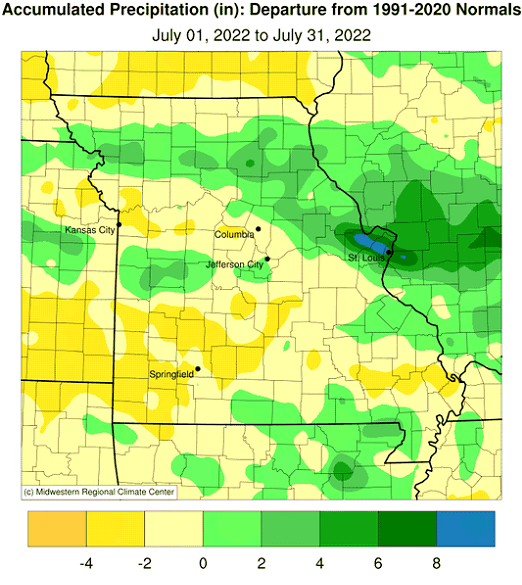
According to radar-estimates, rainfall was highly variable in Missouri, Figure 6. Heaviest rainfall occurred over portions of northern and east central sections where 5-8 inches were common. Additionally, there was corridor, 30-40 miles wide, of heavier rainfall, 5-8 inches, centered on the Cass County and Bates County line eastward to Cole County, near Jefferson City. Driest conditions were found across much of southern Missouri, especially southwestern sections where several locations reported less than 1-inch.
Some of the Heaviest and lightest monthly rain gauge reports are listed in Table 2.
| MISSOURI RAINFALL JULY 2022 | |||
| Station Name* | County | Total Rainfall (in.) | |
| Heaviest | Ladue 1.6 N | St. Louis | 16.94 |
| St. Peters 2.2 NE | St. Charles | 16.50 | |
| West Plains 8.8E | Howell | 11.25 | |
| Mac Kenzie 0.3 ESE | St. Louis City | 10.97 | |
| Windsor 4.2 SSE | Henry | 9.38 | |
| Lightest | Mount Vernon 0.2 E | Lawrence | 0.52 |
| Carthage 1.5 S | Jasper | 0.53 | |
| Buffalo 2 N | Dallas | 0.63 | |
| Neosho 3.9 WNW | Newton | 0.78 | |
| Springfield 5.5 SSW | Greene | 0.79 | |
| *Rain gauges are from the NWS Cooperative Network and CoCoRaHS | |||
| Table 2. | |||
A historic extreme rainfall event impacted the St. Louis area on July 26 with some locations in St. Charles and St. Louis Counties reporting more than 1-foot of rain over a 24-hour period, according to radar estimates and rain gauge reports, Figures 7 and 8. The National Weather Service Office in St. Louis wrote an excellent storm analysis on the event titled: July 26th, 2022: Historic Flash Flooding in St. Louis. It was the first time the NWS office in St. Louis issued a flash flood emergency. There were numerous reports of flooded roads, residences and businesses. At least two flood related fatalities were reported.
According to the Missouri Agricultural Statistics Service report from July 31, 2022, 46% of the state reported topsoil moisture supplies in short to very short condition with 54% of the state reporting topsoil moisture in adequate condition. Statewide subsoil condition was reported 48% short to very short, and 52% adequate. Corn, soybean and pasture conditions were reported at 23%, 21%, and 51% in poor to very poor condition, respectively. Corn and soybean were reported in good to excellent condition at 52% and 49%, respectively. Pasture was in good to excellent condition at 22%. The majority of hay and other roughages were adequate to surplus (67%), as well as stock water supplies (70%).
Moderate to extreme drought was impacting much of the southern half of Missouri toward the end of July, according to the U.S. Drought Monitor released on July 28, 2022, Figure 9. Driest conditions were affecting all of southwestern Missouri and several counties on the Missouri-Arkansas border. More than 200 Condition Monitoring Observer Reports were submitted in July according to the National Drought Mitigation Center, Figure 10. Many of the impacts were affecting agriculture with numerous reports of crop, pasture and livestock stress. Hydrological concerns were also emerging with lowering surface water supplies.
Jump to:
- Figure 1
- Figure 2
- Figure 3
- Figure 4
- Figure 5
- Figure 6
- Figure 7
- Figure 8
- Figure 9
- Figure 10
- Figure 11
- Figure 12
- Figure 13
- Figure 14
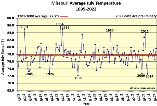
Figure 1.
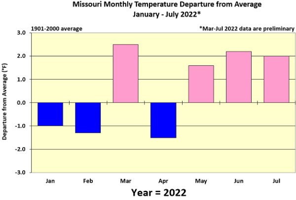
Figure 2.
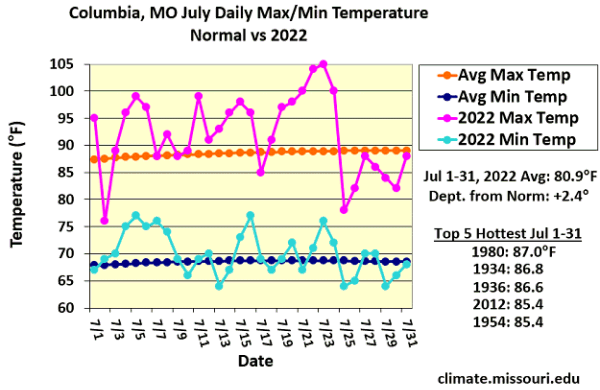
Figure 3.
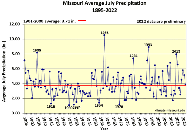
Figure 4.
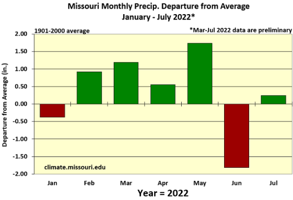
Figure 5.
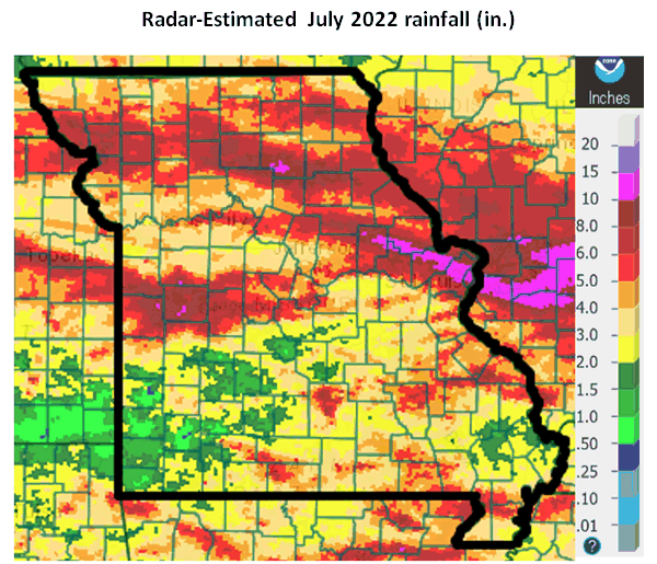
Figure 6.
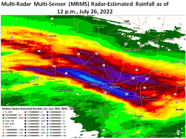
Figure 7. Source: National Weather Service - St. Louis, MO

Figure 8.
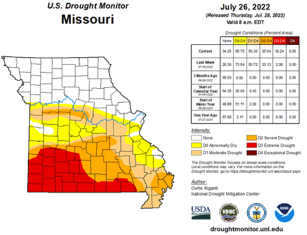
Figure 9.
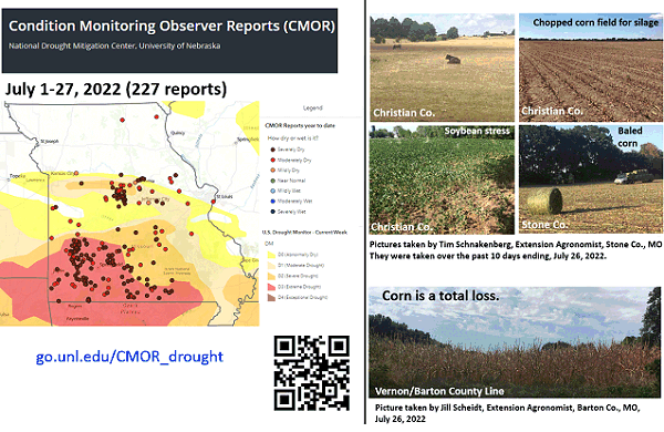
Figure 10.
Source: Pat Guinan, 573-882-5908