
July 2020 Weather and Its Impacts on Missouri
Pat Guinan
State Climatologist
University of Missouri Extension
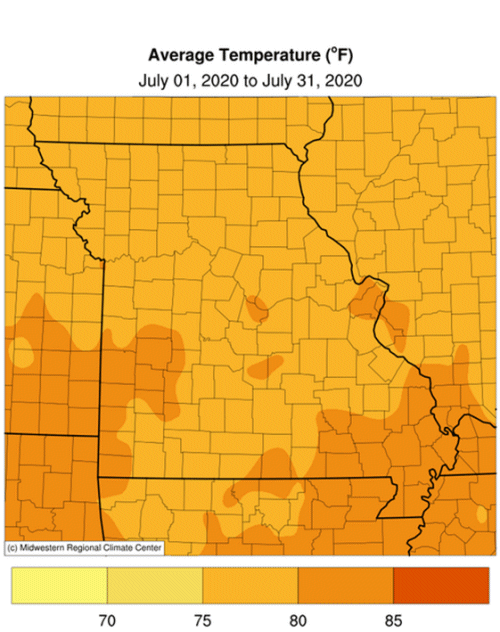
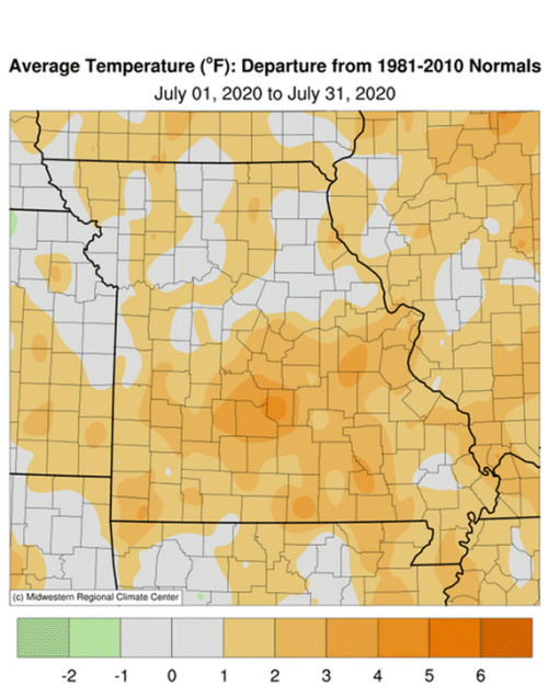
Above average temperatures impacted Missouri in July with preliminary data indicating a statewide average temperature of 79.2�F, or 1.6� above the long-term average, Figure 1. It was the second consecutive warmer than average month and fifth for the year, Figure 2. Daily temperatures for July were seasonably warm, but not extreme, with highest temperatures reaching the lower 90�s statewide and minimum temperatures staying in the 60�s and 70�s. No triple-digit heat was reported and there were more days when daily minimum temperatures were above average due, in part, to above average dew point temperature. High dew points elevate minimum air temperatures while suppressing maximum temperatures. The high July dew points this year paralleled the trend Missouri has experienced over the past few decades, Figure 3.
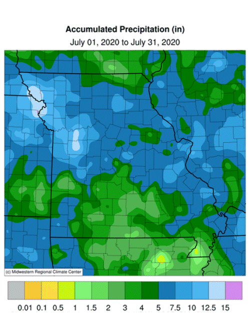
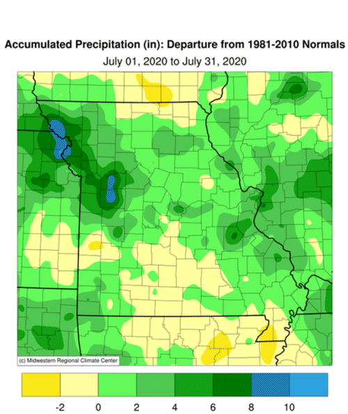
July precipitation was above average across the state with the exception of a few areas in southwestern and south central Missouri as well as a few northeastern counties bordering Iowa and the southern tip of the Bootheel. Preliminary data indicate the statewide average total was 5.84 inches, or 2.02 inches above the long-term average, Figure 4. Five out the past seven months have been wetter than average this year, Figure 5.
According to radar-estimated rainfall, Figure 6, heaviest rainfall occurred over portions of northwestern, west central and east central Missouri where 5-8 inches were common. Driest conditions were across parts of southern Missouri. An extreme rainfall event in west central Missouri at the end of the month was reported in St. Clair County where a CoCoRaHS observer reported nearly a foot of rain in a 24-hour period, Figure 7. Some of the lightest and heaviest monthly rain gauge reports are listed in Table 1.
| Missouri Heaviest and Lightest July 2020 Rainfall (in) | |||
| Station Name* | County |
Rainfall (in) | |
| Lightest | Steele 6W | Pemiscot | 0.57 |
| Senath | Dunklin | 0.69 | |
| Licking 4.0N | Texas | 1.12 | |
| Tecumseh 1.0NE | Ozark | 1.55 | |
| Nixa 2.7SSW | Christian | 1.65 | |
| Heaviest | Mound City 0.2WNW | Holt | 15.48 |
| Warrensburg 4.0NW | Johnson | 15.45 | |
| Lexington | Lafayette | 14.64 | |
| Jefferson City 3.0ESE | Cole | 14.13 | |
| Smithville 3.4E | Clay | 13.29 | |
| *Rain gauges are from the NWS Cooperative Network, CoCoRaHS & Missouri Mesonet | |||
| Table 1. | |||
According to the Missouri Agricultural Statistics Service report from July 26, 2020, 26% of the state reported topsoil moisture supplies in short to very short condition with 71% of the state reporting topsoil moisture in adequate condition. Statewide subsoil condition was reported 21% short to very short, and 78% adequate. Corn, soybean and pasture conditions were reported at 7%, 7%, and 14% in poor to very poor condition, respectively. The majority of corn and soybean were reported in good to excellent condition at 73% and 69%, respectively. The majority of pasture was in good to excellent condition at 53%. The majority of hay and other roughages were adequate to surplus (90%), as well as stock water supplies (92%).
Abnormally dry to moderate drought was impacting all of southwestern Missouri as well as parts of south central Missouri and the southern tip of the Missouri Bootheel, according to the U.S. Drought Monitor map released on July 30, 2020, Figure 8.
Jump to:
- Figure 1
- Figure 2
- Figure 3
- Figure 4
- Figure 5
- Figure 6
- Figure 7
- Figure 8
- Figure 9
- Figure 10
- Figure 11
- Figure 12
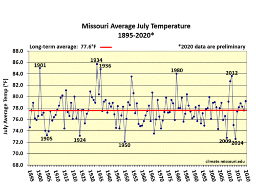
Figure 1.
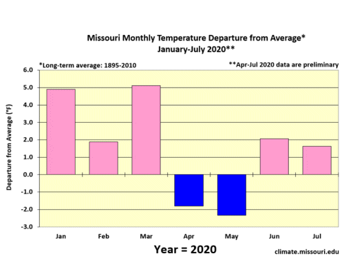
Figure 2.
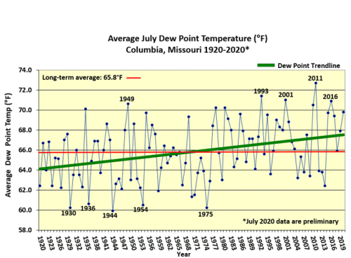
Figure 3.
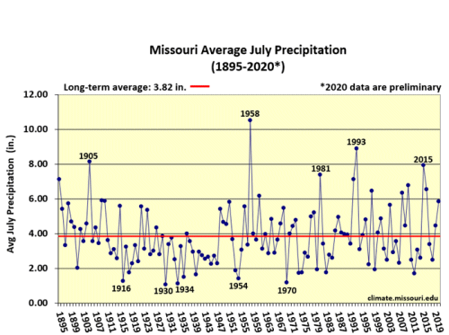
Figure 4.
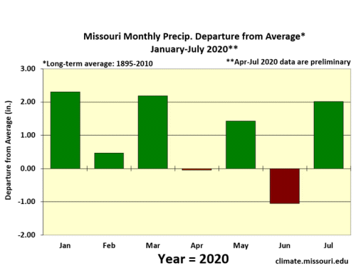
Figure 5.
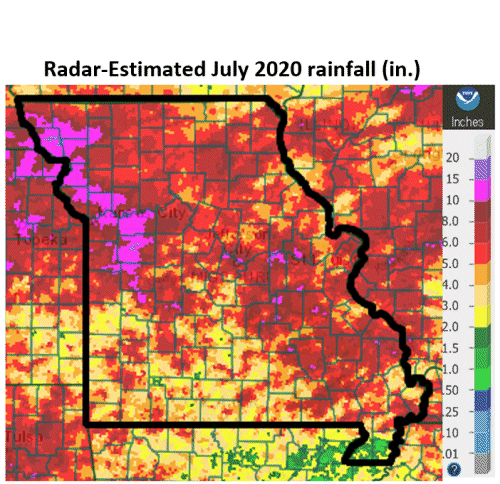
Figure 6.
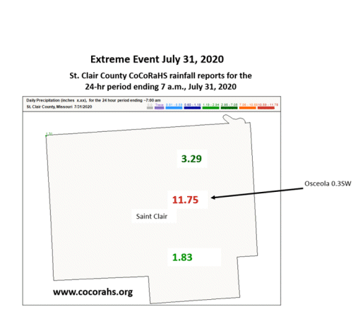
Figure 7.
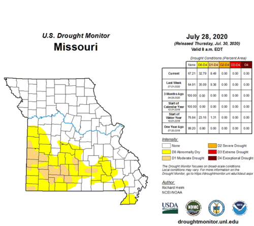
Figure 8.
Source: Pat Guinan, 573-882-5908