
July 2019 Weather and Its Impacts on Missouri
Pat Guinan
State Climatologist
University of Missouri Extension
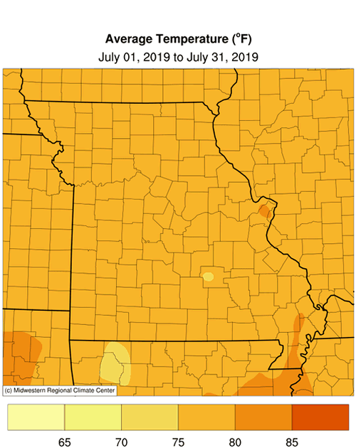
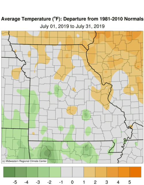
Near average temperatures impacted Missouri in July with preliminary data indicating a statewide average temperature of 77.8�F, or 0.2� above the long-term average, Figure 1. Seasonable temperatures have impacted Missouri for much of the growing season this year, Figure 2. With the exception of a 4-day hot spell in mid-July when high temperatures climbed into the middle 90�s, Figure 3, daily temperatures were not too extreme during the month. No triple-digit heat was reported and there were more days when daily minimum temperatures were above average due in part to above average dew point temperatures during the month. High dew points keep minimum air temperatures elevated while suppressing maximum temperatures. The high July dew points this year paralleled the trend Missouri has experienced over the past few decades, Figure 4.
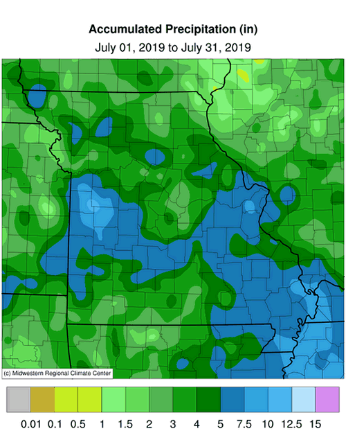
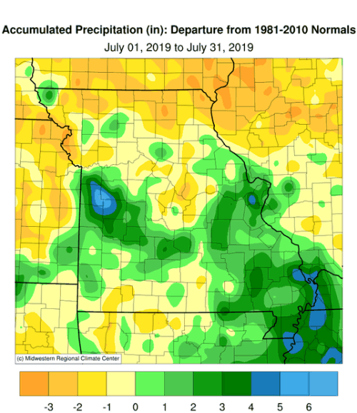
July precipitation was variable across Missouri but the overall total was above average with preliminary data indicating a statewide average of 4.41 inches, or 0.58 inches above the long-term average, Figure 5. The past twelve months have been exceptionally wet across Missouri with only three months experiencing below average precipitation, Figure 6. The Aug-Jul period ranks as the third wettest Aug-Jul on record, and wettest Aug-Jul since 1972-1973, Figure 7.
According to radar rainfall estimates, Figure 8, heaviest rainfall occurred over portions of west central, south central, east central and southeast Missouri where more than five inches were common. Wet and dry pockets were also notable over the northern half of Missouri. Another dry area was found over some far southwestern and south central counties in a corridor extending from McDonald to Douglas and Carter Counties. Some of the lightest and heaviest monthly rainfall totals are listed in Table 1.
| July 2019 | |||
| Station Name* | County |
Rainfall (in.) | |
| Lightest | Platte City 2.9NNE | Platte | 1.13 |
| Kirksville AP | Adair | 1.23 | |
| Crane 0.7SSW | Stone | 1.40 | |
| Jefferson City 2.6NW | Cole | 1.41 | |
| Holts Summit 2.5NNE | Callaway | 1.86 | |
| Heaviest | Kingsville 2.2WSW | Johnson | 13.30 |
| Garden City 3.9N | Cass | 10.92 | |
| Manchester 1.4SE | St. Louis | 10.90 | |
| Junction City 0.8W | Madison | 9.91 | |
| Urich 6.6SW | Bates | 9.60 | |
| *Rain gauges are from the NWS Cooperative Network or CoCoRaHS Network | |||
| Table 1. | |||
According to the Missouri Agricultural Statistics Service report from July 28, 2019, 16% of the state reported topsoil moisture supplies in short to very short condition with 75% of the state reporting topsoil moisture in adequate condition. Statewide subsoil condition was reported 11% short to very short, and 78% adequate. Corn, soybean and pasture conditions were reported at 24%, 17%, and 7% in poor to very poor condition, respectively. Corn and soybean were reported in good to excellent condition at 34% and 41%, respectively. The majority of pasture was in good to excellent condition at 72%. The majority of hay and other roughages were adequate to surplus (84%), as well as stock water supplies (98%).
No official drought status was indicated in Missouri by the end of July, Figure 9. Only portions of Nodaway and Worth Counties were identified as abnormally dry.
Jump to:
- Figure 1
- Figure 2
- Figure 3
- Figure 4
- Figure 5
- Figure 6
- Figure 7
- Figure 8
- Figure 9
- Figure 10
- Figure 11
- Figure 12
- Figure 13
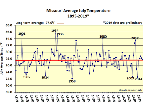
Figure 1.
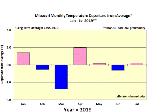
Figure 2.
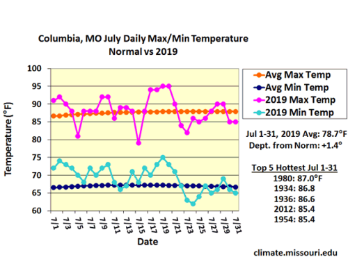
Figure 3.
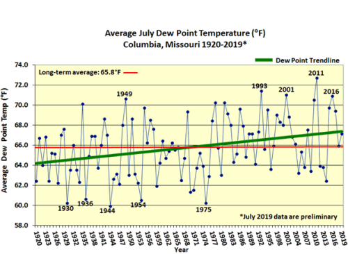
Figure 4.
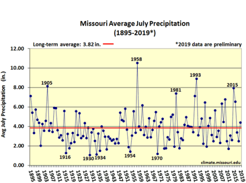
Figure 5.
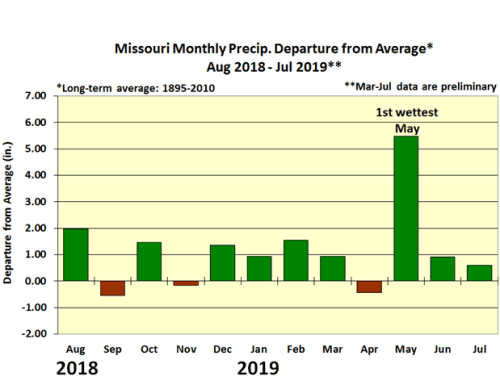
Figure 6.
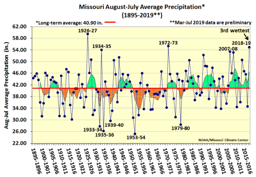
Figure 7.
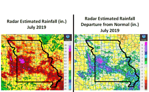
Figure 8.
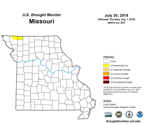
Figure 9.
Source: Pat Guinan, 573-882-5908