
July 2017 Weather and Its Impacts on Missouri
Pat Guinan
State Climatologist
Commercial Agriculture/University of Missouri Extension
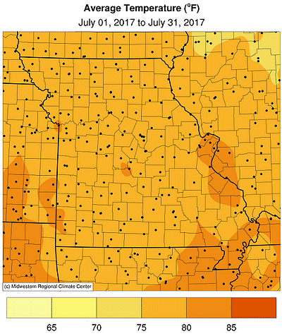
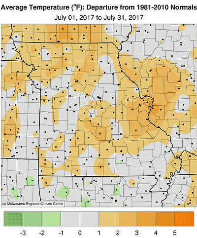
The overall weather conditions in Missouri for July was hotter and drier than normal, but there was notable variability in areas of the state. Preliminary data indicate the statewide average temperature for the month was 78.7°F, or 1.1 degrees above the long-term average, Figure 1. Some areas of the state were hotter than others with highest positive departures over east central and north central sections, Table 1.
| July 2017 Average Temperature, Departure From Normal | |||
| Station Name | County | July 2015 Avg. Temp (°F) | Departure From Normal (°F) |
| St. Joseph | Buchanan | 78.5 | +1.4 |
| Kirksville | Adair | 77.9 | +2.8 |
| Hannibal | Marion | 78.2 | +1.8 |
| Kansas City | Platte | 79.1 | +0.8 |
| Columbia | Boone | 79.2 | +1.9 |
| St. Louis | St. Louis | 84.3 | +4.3 |
| Springfield | Greene | 79.7 | +1.5 |
| Vichy/Rolla | Phelps | 78.0 | +0.7 |
| West Plains | Howell | 79.1 | +1.1 |
| Cape Girardeau AP | Scott | 79.0 | +0.4 |
| Table 1. | |||
Some of the hottest temperatures experienced in 5 years occurred during a 5-day heat wave from July 18-22. High heat indices accompanied the hot weather and made it particularly challenging for people without air conditioning and outdoor laborers. The urban environment of St. Louis was particularly uncomfortable with triple digit heat on 4 consecutive days, including a record high of 108° on the 22nd of the month, Figure 2. July 2017 ranked as the 8th hottest July on record for St. Louis. The warmer than average month follows a warm trend that has been ongoing for nearly two years, Figure 3.
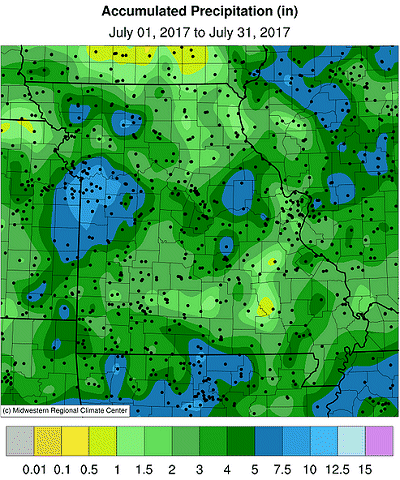
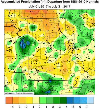
Rainfall was highly variable across the state, but the statewide average total was 3.38 inches, or 0.44 inches below the long-term average. Wettest conditions, where more than 4-inches were reported, were found over portions of northwestern, west central, central and southeastern Missouri. Driest locations, where less than 2-inches were observed, occurred along Highway 36 in northern Missouri, from St. Joseph to Hannibal. Another dry corridor extended from St. Louis southwestward to Texas County, in south central Missouri, on westward to just east of Joplin, MO, Figure 4. Some of the heaviest and lightest monthly rainfall totals around the state are listed in Table 2.
| July 1-31, 2017 Rainfall reports (NWS Coop and CoCoRaHS) | ||
| Station Name | County | July 1-31 Precip (in.) |
| Kansas City South | Jackson | 11.63 |
| North Kansas City 0.6 NNW | Clay | 11.14 |
| Odessa 1.9 ENE | Lafayette | 10.60 |
| Pleasant Valley 0.8 NW | Clay | 10.44 |
| Elm | Johnson | 10.29 |
| Raymore 1.2 SE | Cass | 10.18 |
| Potosi | Washington | 0.43 |
| Kirksville Regional AP | Adair | 0.92 |
| Caplinger Au Gris L&D | Lincoln | 1.00 |
| Arnold 0.5 E | Jefferson | 1.03 |
| Cameron | De Kalb | 1.05 |
| Marshfield 4.1 WSW | Webster | 1.10 |
| Table 2. | ||
According to the Drought Monitor map, drier conditions had expanded in Missouri since the end of June, especially over southern, east central and northeastern sections of the state, Figure 5. Moderate drought was depicted from St. Louis County southwestward to Crawford County. Many pastures in this region were in very poor condition, Figures 6 and 7.
On July 12-13 an extreme rain event impacted portions of northwestern and north central Missouri, from Grundy to Linn counties. An observer residing 1.3 miles east-southeast of Jamesport, in Daviess County, reported 9.30 inches the morning of July 13. Another observer residing 5.5 miles south-southeast of Trenton, in Grundy County, reported 8.68 inches that morning. Flash flooding was reported in the area.
Another extreme rain event impacted west central Missouri on July 26-27, including the Kansas City metro area, with several locations reporting 4-7 inches. Heaviest reports of more than 8-inches were observed in Johnson County (Odessa, 6.7 SSW, 8.52"), Lafayette County (Odessa, 1.9 ENE, 8.60") and Clay County (Gladstone, 1.1 NE, 8.75"). Major flash flooding occurred during the event with numerous water rescues reported around the Kansas City area. Fortunately, there were no casualties.
According to the Missouri Agricultural Statistics Service report from July 30, 2017, 59% of the state reported topsoil moisture supplies in adequate condition with 35% of the state reporting topsoil moisture in short condition. Statewide subsoil condition was reported 68% adequate. Corn, soybean and pasture conditions were reported at 61%, 65%, and 50% in good to excellent condition, respectively. The majority of hay and stock water supplies were adequate to surplus.
Jump to:
- Figure 1
- Figure 2
- Figure 3
- Figure 4
- Figure 5
- Figure 6
- Figure 7
- Figure 8
- Figure 9
- Figure 10
- Figure 11
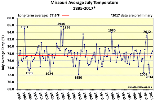
Figure 1.
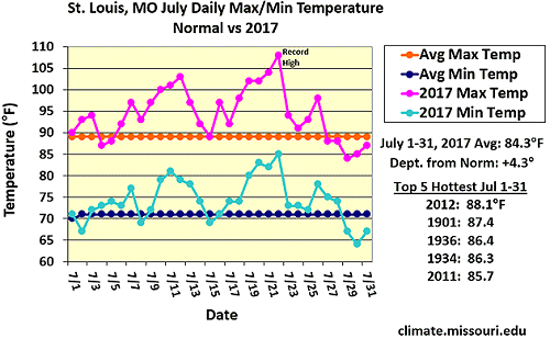
Figure 2.
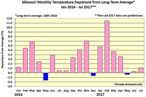
Figure 3.
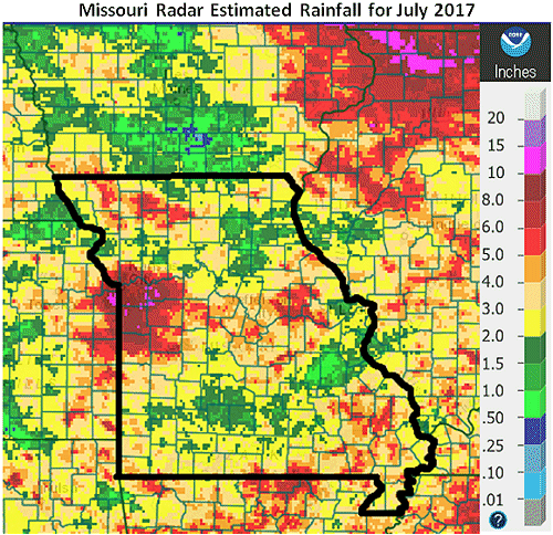
Figure 4.
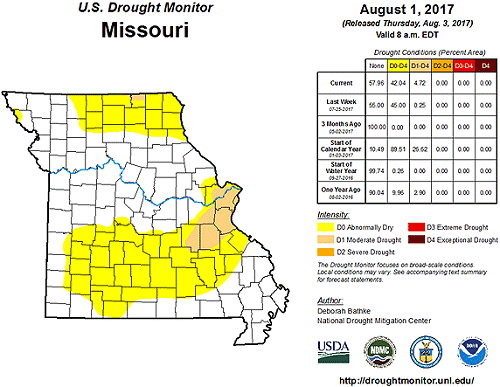
Figure 5.
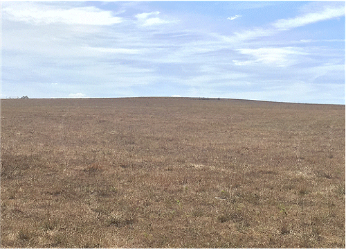
Figure 6. Washington County, near Potosi, Missouri, Photo: Rachel Hopkins
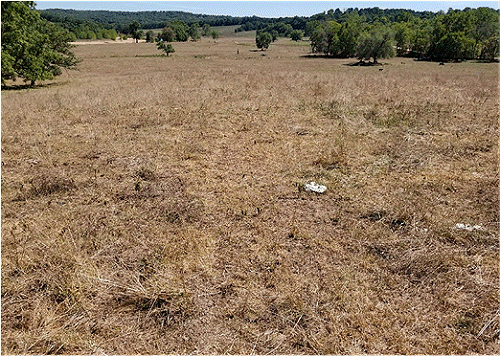
Figure 7. Crawford County, near Dillard, Missouri, Photo: Rachel Hopkins
Source: Pat Guinan, 573-882-5908