
July and August rainfall in Missouri: The tale of the haves and the have-nots
Debbie Johnson
Senior Writer
University of Missouri Cooperative Media Group
August 19, 2013
To download broadcast-quality audio, go to http://radionews.missouri.edu.
Log in with the name of your news organization (password/registration not required). For questions regarding the audio download site, contact Debbie Johnson at 573-882-9183.
COLUMBIA, Mo. - There were vast regional differences in rainfall in Missouri for July and August. Parts of the state were too wet while others were too dry.
"The trend was dryer across northern Missouri, wetter as you went south across the state," said Pat Guinan, climatologist for the University of Missouri Extension Commercial Agriculture Program.
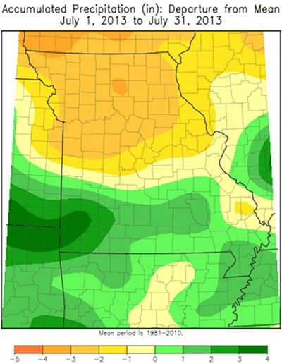
In July there were heavy pockets of precipitation in parts of southwestern Missouri where a few counties had 7-10 inches of rain. At the same time, parts of north central and west central Missouri saw less than 1 inch of rain, Guinan said.
Statewide, July rainfall averaged just over 3.5 inches, which is slightly below normal. That makes July the first month in 2013 with below-normal precipitation, Guinan said. Overall, the northern half of the state saw 1-3 inches, while the southern half had 3-6 inches.
"So far, through the first two weeks of August, most of southern Missouri has received more than 5 inches of rain, and parts of south central Missouri have seen anywhere from 10-20 inches. Twenty inches of rain in any month is very unusual," Guinan said. "But travel 120 miles to the north and there's a drought. Some locations in northern Missouri have seen no measurable rainfall for August. That's incredible precipitation disparity."
A stubborn upper-air weather pattern over the past several weeks was creating that disparity.
"There has been a strong area of low pressure across northeastern Canada. At the same time there's been a strong ridge of high pressure across the southwestern United States. Missouri is sandwiched in the middle," Guinan said.
That pattern put Missouri under a northwesterly flow regime with occasional disturbances moving along it, Guinan said. Add surface conditions that were favorable for storm activity and it was a recipe for lots of rain in parts of the Show-Me State.
There was a stationary front over parts of Kansas, southern Missouri into Tennessee, plus a low-level flow of Gulf of Mexico moisture that interacted with that front. These features, in combination with the aforementioned upper-level conditions, provided several opportunities for thunderstorm complexes to develop and drop prolific rainfall over the area for many days, Guinan said.
Less than 150 miles to the north and those favorable rain conditions disappeared. We didn't have a frontal boundary across northern Missouri to serve as a catalyst for initiating shower and thunderstorm activity.
Summer temperatures have also been notably low this year, Guinan said. July was slightly more than 2 degrees below normal and August is currently running about 3 degrees below normal for the state. "So far, it's our coolest summer since 2009," Guinan said.
July 2013 Weather and Its Impacts on Missouri: http://climate.missouri.edu/
Wide discrepancy in rainfall from northern to southern Missouri
Photo credit: Pat Guinan
Source: Pat Guinan, 573-882-5908