
July 2013 Weather and Its Impacts on Missouri
Pat Guinan
State Climatologist
Commercial Agriculture/University of Missouri Extension
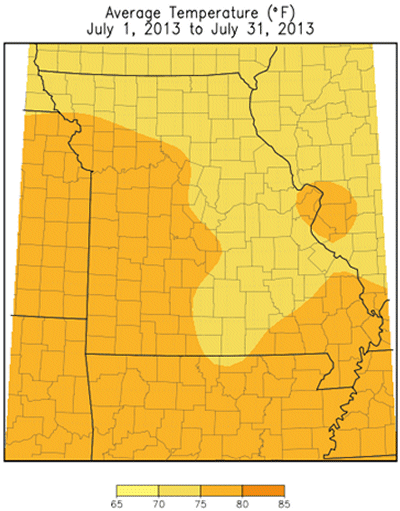
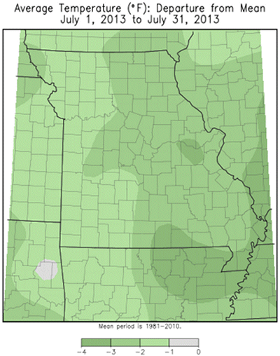
Progressive and unusual weather patterns impacted Missouri during July with overall statewide conditions trending toward a cooler and drier month than normal, but with large precipitation disparities from north (drier) to south (wetter). Preliminary data indicate a statewide average temperature of 75.2°F, or slightly more than 2 degrees below normal. It was the first cooler than normal July since 2009, Figure 1.
During the first week of July a deep trough of low pressure over the Midwest brought cool conditions to the Show Me State. Eventually, a ridge of high pressure over the desert southwest expanded northeastward into the central U.S. bringing a period of hotter, more seasonable weather to Missouri during the second week of the month. These above normal temperatures, however, were temporary as a strengthening ridge of high pressure off the Mid-Atlantic Coast forced an upper level low to retrograde westward from Ohio to Missouri by mid-month. Temperatures cooled again due to the influence of this feature. By the third week of July, the high pressure ridge over the Mid-Atlantic expanded westward to cover the eastern half of the country. This pattern brought the hottest temperatures of the year to Missouri with many locations across the state experiencing highs in the lower to middle 90's. The hot weather, however, was short-lived as an intensifying polar vortex over Hudson Bay forced a cold front southward through Missouri, effectively breaking down the ridge and bringing cooler, below normal temperatures to the region. The last week of the month was notably cool with Missouri sandwiched between a ridge of high pressure over the southwestern U.S., and trough of low pressure over the upper Great Lakes.
Using Columbia, Missouri as a midpoint, Figure 2 shows the roller coaster temperatures impacting the state for the month and the unusually cool period during the last week. There were several days when maximum temperatures stayed in the 70's during this time. Several locations across the state reported record low minimum temperatures on July 27, 28 and 29, including 52°F at the Columbia Regional Airport on the 28th.
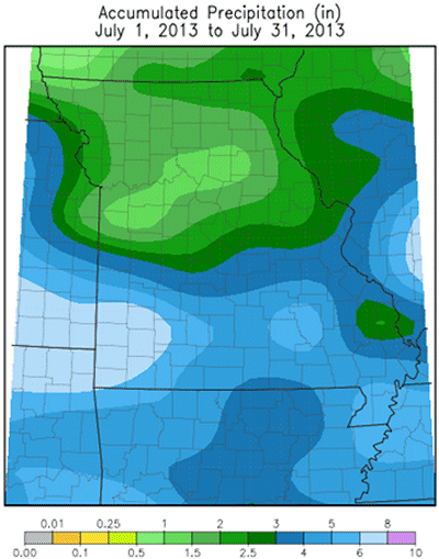
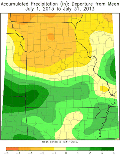
The upper level low circulations that impacted Missouri during the first 3 weeks of the month brought scattered afternoon thunderstorms to the state, but most locations missed out on significant rainfall during this time, especially across northern and central sections. Widespread significant precipitation events were confined to the last 10 days of the month with southern Missouri being the primary benefactor. Overall, statewide rainfall averaged just over 3.5 inches, which is slightly below normal. It was the first below normal precipitation month for the year, Figure 3. Precipitation was highly variable, but generally ranged from 1-3 inches across the northern half of the state to 3-6 inches over the southern half of Missouri. Heaviest pockets of precipitation occurred over southwestern sections where a few counties reported 7-10 inches. Two CoCoRaHS observers in northwestern Lawrence County reported 10.55 and 12.62 inches for the month. An extreme precipitation event was reported by these observers on the morning of July 30th when they reported 24-hour totals of 6.29 inches and 7.39 inches, respectively. The lowest July rainfall totals were confined to parts of north central and west central Missouri where several locations reported less than 1-inch for the month. The Drought Monitor map began to show these emerging dry conditions across parts of Missouri as the month progressed. By the end of the month, abnormally dry conditions to moderate drought were impacting much of the northern half of the state, Figure 4. Crop stress was beginning to emerge in the driest areas, with some firing and leaf curling reported, especially in upland or higher claypan or sandy soils. Unseasonably cool temperatures, in combination with below normal evapotranspiration rates, were mitigating full drought stress potential.
According to the Missouri Agricultural Statistics Service, 50% of the state reported topsoil moisture supplies in adequate to surplus condition by the end of the month. Corn, soybean and pasture conditions were doing significantly better this year compared to last year with 49%, 48%, and 44% in good to excellent condition, respectively. The majority of hay and stock water supplies were also adequate to surplus.
Jump to:
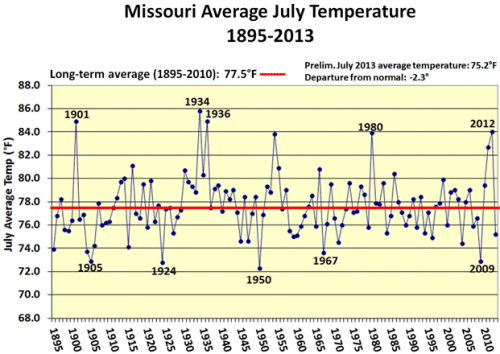
Figure 1
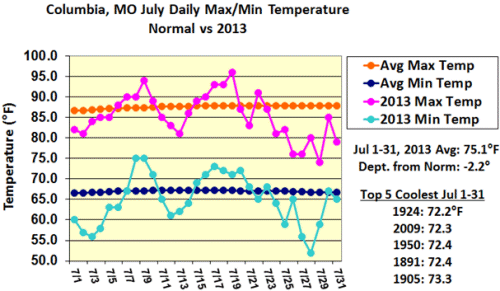
Figure 2
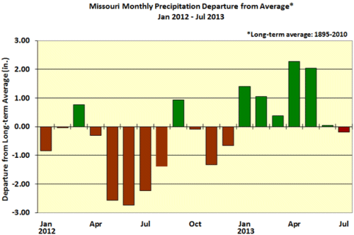
Figure 3
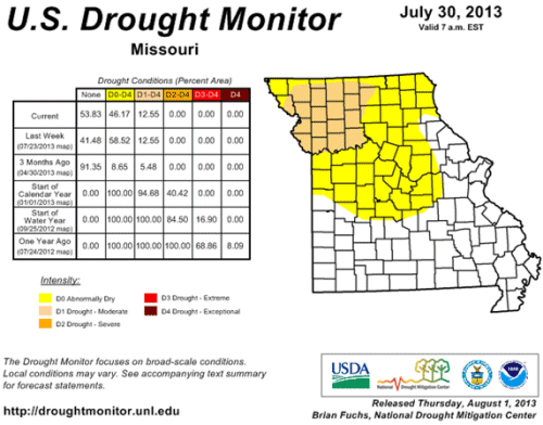
Figure 4
Source: Pat Guinan, 573-882-5908