Southwest Missouri Weather and Climate Summary
Pat Guinan
State Climatologist
University of Missouri Extension/Commercial Agriculture
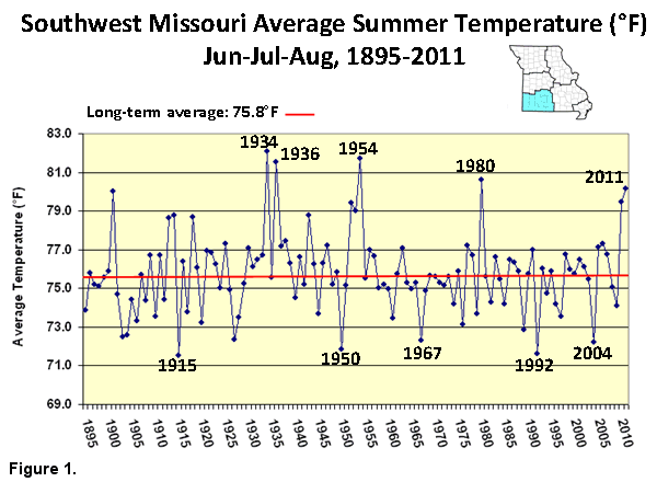
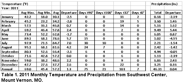
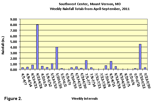
For two consecutive summers southwestern Missouri has been hit hard by extreme heat and drought with numerous agricultural impacts. In 2011, southwestern Missouri was on the northeastern edge of a devastating summer heat wave and drought impacting the southern Plains states. The spring of 2011 was unusually wet across southwestern Missouri, but the faucet abruptly turned off in June, and the summer of 2011 became the hottest summer in more than 3 decades (Figure 1). Relentless triple digit heat and lack of rainfall combined to create widespread crop and pasture losses, water shortages and livestock stress. Table 1 shows 2011 monthly temperature and precipitation data from Southwest Center, Mount Vernon, Missouri, and Figure 2 provides a weekly breakdown of rainfall during the 2011 growing season for the same location.
In 2012, dryness began to emerge in April over southeastern and west central sections of Missouri, where a few locations in the Bootheel reported less than 1-inch for the month. As May progressed, dry conditions spread across much of the state, however, some rain events toward the end of May over southwestern sections, managed to stave off dryness temporarily.
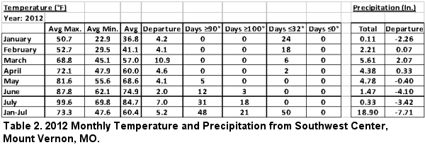
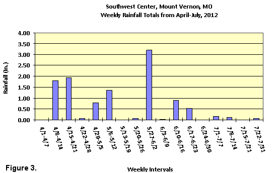
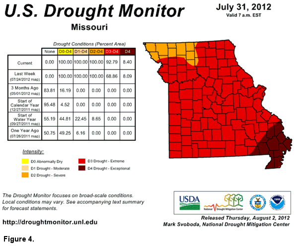
Hot, dry weather impacted all of Missouri during June and the drought intensified when record heat affected the state during the latter half of the month. Numerous high temperature records were broken as the mercury climbed well above the century mark for several days. Similar to 2011, southwestern Missouri saw conditions rapidly deteriorate toward the latter half of June and throughout July. Table 2 shows the monthly temperature and precipitation totals for Southwest Center, Mount Vernon, MO during the first 7 months of 2012, and Figure 3 provides weekly precipitation totals that occurred at Southwest Center from April through July 2012. According to the NOAA/USDA Drought Monitor map, all of southwestern Missouri was experiencing extreme drought by the end of July this year (Figure 4).
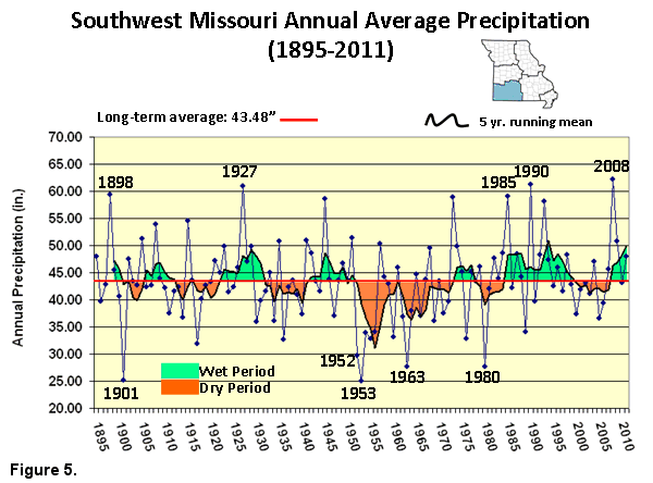
A frequent question I’ve been asked lately, is if we’re entering a period of extended drought for Missouri? My initial response to the question is that drought will always be a part of the Missouri landscape - it always as, and it always will be. In fact, the past 30 years have been a benign period when it comes to extreme or multi-year droughts impacting southwestern Missouri (Figure 5). Since the 1980’s, an unprecedented wet trend has dominated, and the 1980’s and 1990’s are the two wettest consecutive decades on record for southwest Missouri. Southwest Missouri’s wettest year on record is 2008.
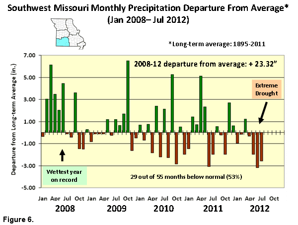
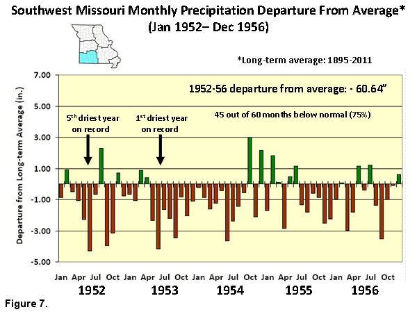
The most notable and intense drought period to impact southwestern Missouri occurred from 1952 to 1956; a five-year drought that brought enormous and long-lasting hardship to the region. To put the past 5 years in perspective, Figures 6 and 7 show monthly precipitation departures from 2008 to current, and 1952-1956, respectively. Undoubtedly, the past two years have been challenging in southwestern Missouri, but the 5-year drought in the 1950’s provides a baseline of how bad things can get. Despite two consecutive summers with severe drought in 2011-12, a precipitation surplus of 23.32 inches accumulated from January 2008 to July 2012 across southwestern sections. Alternatively, from January 1952 through December 1956, a deficit greater than 5 feet had accumulated over southwestern Missouri, or an amazing 60.64 inches below normal.
Climate history shows large precipitation variability can occur on a weekly, monthly, seasonal and annual basis, and predicting if the current drought will break or continue is extremely challenging. Short or long-term weather pattern changes can be abrupt and/or unpredictable.
An important question that comes to mind for me, is how prepared are we when the next 1950’s drought affects the Show Me State?