July 2011 Weather and Its Impacts on Missouri
Pat Guinan
State Climatologist
Commercial Agriculture/University of Missouri Extension
A ridge of high pressure over the southern Plains intensified and expanded northeastward in July, profoundly influencing the weather pattern across the Show-Me state for the month. Hot and dry conditions spread across Missouri and had adverse impacts on people, animals and vegetation.
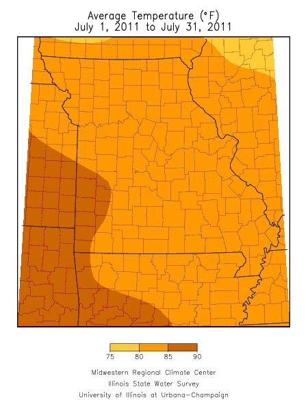
Preliminary numbers indicate Missouri witnessed its hottest month in more than 30 years. The average statewide temperature for the month was 83°F, slightly over 5 degrees above normal, and the hottest month since July 1980. It was also the 6th hottest July on record and will go down as the 8th or 9th hottest month of all time when final numbers are tallied.
Monthly temperatures averaged 81-82°F across northern sections and the eastern Ozarks region, 82-84°F over central, east central and southeastern sections and 84-87°F in west central and southwestern Missouri. Springfield and Joplin, MO experienced 8 and 19 days, respectively, of triple digit heat and both recorded their 3rd hottest July on record. The highest temperature for the month was reported in two southwestern locations on separate days. The communities of Protem (Taney Co.) and Ava (Douglas Co.) reported 107°F on July 11 and July 27, respectively.
Hot temperatures and high humidity combined to produce very uncomfortable and life threatening conditions during the month. There were lengthy and continuous periods of various heat advisories and warnings impacting the state and, unfortunately, heat related fatalities were reported. According to the Missouri Department of Health and Senior Services, there were 11 heat related fatalities between May 1 and July 31 and another 24 deaths were likely heat related. The majority of deaths occurred during July and in the St. Louis metropolitan area. More than 1,300 heat related visits to emergency rooms were documented statewide for the period.
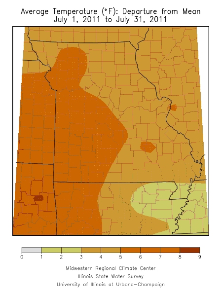
Another feature of the prolonged heatwave was high minimum temperatures. The average July minimum temperature for most areas of Missouri was between 72-74°F, or five to six degrees above normal. Urban locations, i.e. St. Louis and Kansas City, witnessed average monthly minimum temperatures around 77°F. The high maximum and minimum temperatures combined to create records for electricity demand across the state.
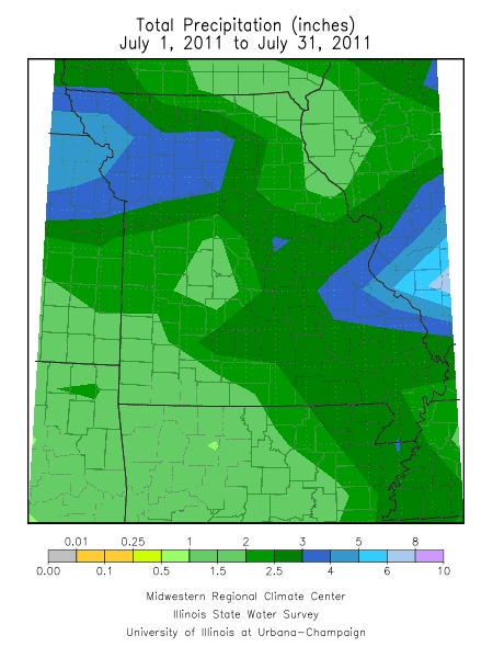
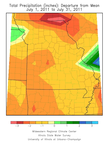
Most areas of the state reported dry conditions at the end of the month and preliminary data indicated a statewide monthly average of 2.52 inches, or 1.43 inches below normal. The majority of precipitation events were scattered and highly localized, but there were a few occasions of significant rainfall.
Heaviest monthly precipitation was confined to northwestern, north central and east central sections, and the eastern Ozarks region. Several northwestern counties reported four to six inches of rain. Rock Port, in Atchison County, received 8.17 inches. Three to four inches were common over north central Missouri and parts of the eastern Ozarks. Two to four inches were reported across east central Missouri, however, a localized area of much heavier precipitation occurred in Ste. Genevieve County where five to nine inches were reported. Two CoCoRaHS observers in Ste. Genevieve County reported 7.86 and 9.54 inches for the month.
Less than two inches were typical over northeastern, central, west central, southwestern and far southeastern sections. Some exceptionally dry pockets were found in parts of northeast, west central, southwest and southeast Missouri where less than 0.75 inches were reported for the month. Some of the lowest monthly totals were 0.50 inches in Purdy (Barry County), 0.44 inches at Lakeside (Miller Co.), and 0.31 inches at Clarence Canon Dam (Ralls Co.).
According to the Missouri Agricultural Statistics Service, 69% of the state reported topsoil moisture supplies in short to very short condition by the end of the month. Corn, soybean and pasture conditions continued to deteriorate with 28%, 19% and 40% in poor to very poor condition, respectively. The southwestern district has been especially hard hit with 84% of the corn and 91% of the soybean crop in very poor condition. Complete crop failures were also reported in southwest Missouri. Burned up pastures were forcing livestock producers to feed hay in some areas.
The National Drought Mitigation Center's July 26 Drought Monitor map indicated abnormally dry conditions affecting the southwestern half of Missouri with some far southwestern counties depicted in a moderate drought.