March 2023 Weather and Its Impacts on Missouri
Dr. Pat Guinan
Climatologist
Extension Associate Professor Emeritus
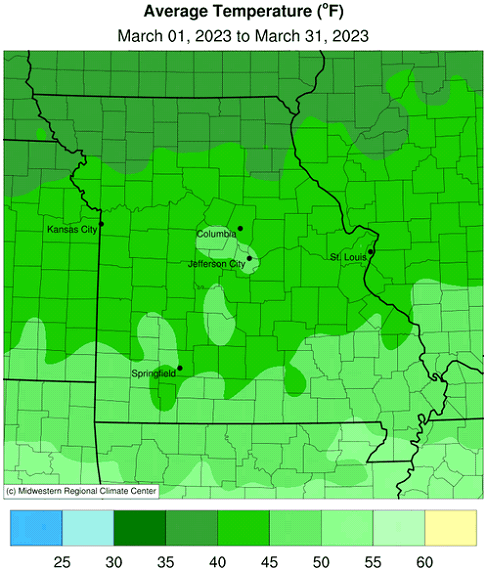
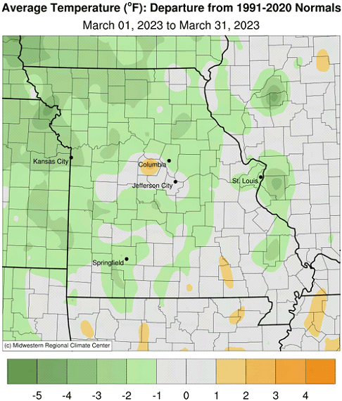
There were alternating periods of above and below normal temperatures during March in Missouri with an unusual two-day cold spell occurring mid-month, Figure 1. Some communities in northwestern Missouri reported single digit minimum temperatures during the mornings of March 18-19. The coldest official minimum temperature for the month was 5°F, on March 19, and occurred in Nodaway County, two miles east of Maryville.
According to preliminary data, the statewide March average temperature was 44.0°F, 0.4° above the long-term average, Figure 2. Two out of the past ten Marches in Missouri averaged warmer than normal. There have been only four months since January 2022 where temperatures were below average, Figure 3.
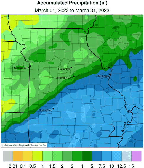
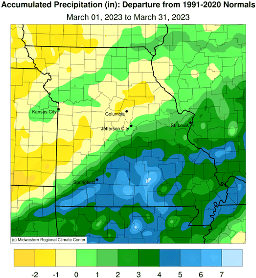
Preliminary data indicate the average statewide March precipitation total was 4.79 inches, or 1.58 inches above the long-term average. March precipitation has been above average for the past seven years, Figure 4. Heaviest amounts impacted southeastern Missouri, generally southeast of line from St. Louis to Springfield, MO. It was the third consecutive wetter than average month; 10 out of the past 15 months have been above average, Figure 5.
There were no major winter weather events and only minor monthly snowfall accumulations reported across the northern half of the state, Figure 6. Two severe weather events occurred with localized hail and high wind reports impacting southern Missouri on the 23rd of the month, Figure 7, and a widespread multi-state tornado, severe hail, and high wind event on the 31st, Figure 8. No tornadoes were documented in Missouri on the 31st, but numerous severe hail and high wind reports were reported, especially across the northeastern quarter of the state. A regional summary of the March 31st severe weather event was written by the National Weather Service Forecast Office in St. Louis and can be found here.
A few dry areas persisted across portions of central and southwestern Missouri, according to the U.S. Drought Monitor map for March 28, 2023, Figure 9, including moderate and severe drought impacting the southwestern counties of Vernon, Barton and Jasper.
A guide to spring frost/freeze probabilities for Missouri can be accessed at the following link:
Missouri Frost Freeze Probabilities Guide
http://ipm.missouri.edu/frostfreezeguide/
The median last spring frost date is defined as the day after which there is a 50 percent chance of a light killing frost (≤32°F). Typically, the last spring frost occurs over northern and central Missouri by April 20 and April 10, respectively. Frosts are more likely to be experienced later in the spring over the Ozarks when compared to central Missouri. The reason for this is due to the higher elevation of the Ozark Plateau which causes cooler temperatures in the Ozark region than would be expected. In fact, some counties in the Ozarks normally do not experience their last frost until the end of April. As the Ozark Plateau transitions to the southeastern lowlands of the Bootheel, the median last spring frost retreats to the first week of April.
Jump to:
- Figure 1
- Figure 2
- Figure 3
- Figure 4
- Figure 5
- Figure 6
- Figure 7
- Figure 8
- Figure 9
- Figure 10
- Figure 11
- Figure 12
- Figure 13
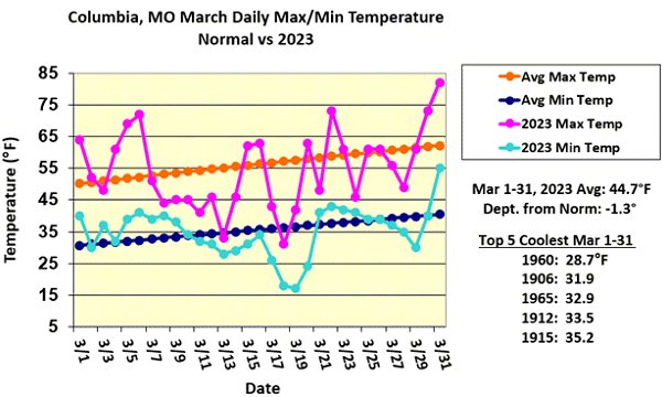
Figure 1.
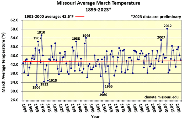
Figure 2.
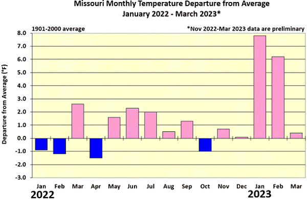
Figure 3.
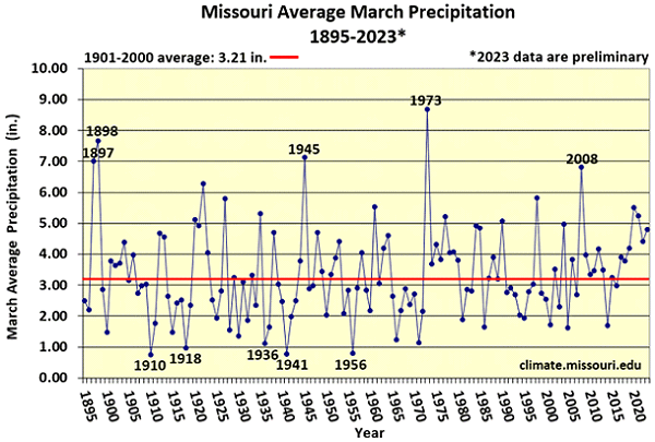
Figure 4.
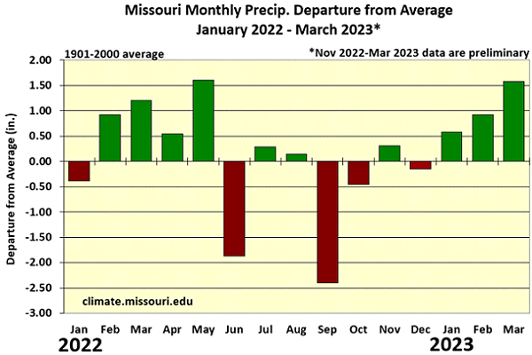
Figure 5.
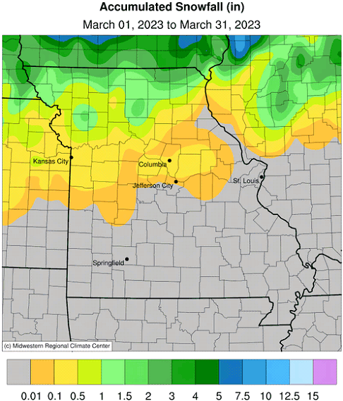
Figure 6.
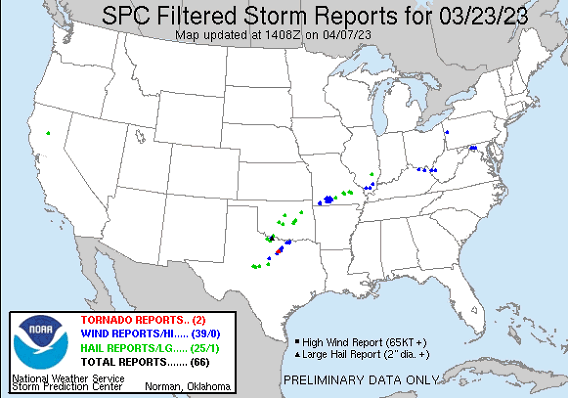
Figure 7.
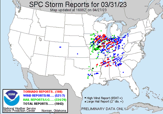
Figure 8.
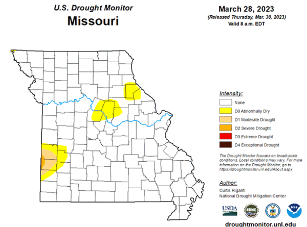
Figure 9.
Source: Dr. Pat Guinan, 573-882-5908


