
March 2021 Weather and Its Impacts on Missouri
Pat Guinan
State Climatologist
University of Missouri Extension
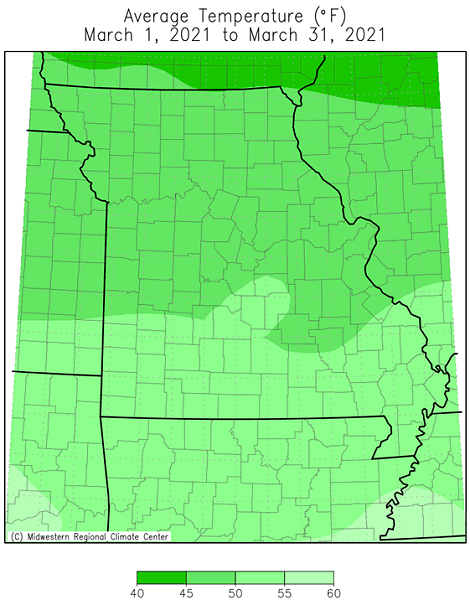
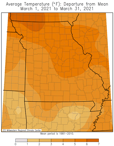
Mild March weather dominated the Show Me state, especially during the first and last 10 days of the month, Figure 1. It was separated by a cool, cloudy and wet period during the middle of March. According to preliminary data, the statewide average temperature for the month was 49.2°F, or 5.6 degrees above the long-term average. It was the warmest March in five years, Figure 2. Out of the past 20 years, only six Marches have been cooler than average. The mild conditions have been the rule over the past several months with the only exception being the two-week arctic blast in February. Four out of the past five months have been warmer than average, Figure 3.
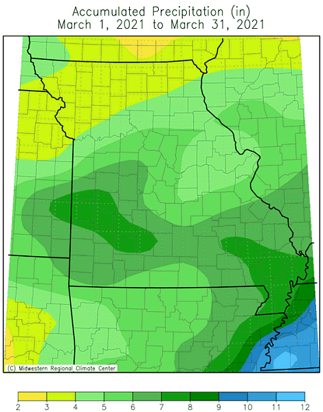
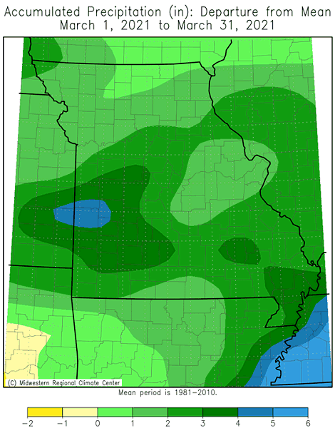
March precipitation was above normal statewide with only a handful of counties in the north central and northeastern Missouri reporting near normal precipitation, according to radar estimates, Figures 4 and 5. Preliminary data indicate the average statewide March total was 5.50 inches, or 2.22 inches above the long-term average. It was the wettest March since last year, Figure 6. The wet conditions limited spring fieldwork activity across the state. Some of the highest and lowest monthly observation totals are listed in Table 1.
| Highest Missouri March 2021 Precipitation (in.) | ||
| Location | County |
Mar 1-31 Precip. (in.) |
| Anderson 3.2NNW | McDonald | 11.93 |
| Marshfield | Webster | 10.89 |
| Fair Grove 4.7SSW | Greene | 9.91 |
| Nevada 3.4NE | Vernon | 8.94 |
| Butler 0.8SSW | Bates | 8.82 |
| Lowest Missouri March 2021 Rainfall | ||
| Location | County |
Mar 1-31 Precip. (in.) |
| Lancaster 0.2SE | Schuyler | 2.73 |
| Princeton 1.4NNE | Mercer | 2.89 |
| Milan 1.2SW | Sullivan | 2.98 |
| Jamesport 1.3ESE | Daviess | 3.01 |
| Trenton 1.2N | Grundy | 3.01 |
Table 1. NWS COOP and CoCoRaHS rain gauge reports for March 2021
Monthly precipitation totals for the past few months have been erratic, alternating between wetter and drier months than average, Figure 7.
The wetter March conditions eliminated any dryness as depicted by the U.S. Drought Monitor map, Figure 8. It was the first time since early June 2020 when all of Missouri was free of any dryness or drought category.
A guide to spring frost/freeze probabilities for Missouri can be accessed at the following link:
Missouri Frost Freeze Probabilities Guide
http://ipm.missouri.edu/frostfreezeguide/
The median last spring frost date is defined as the day after which there is a 50 percent chance of a light killing frost (≤32°F). Typically, the last spring frost occurs over northern and central Missouri by April 20 and April 10, respectively. Frosts are more likely to be experienced later in the spring over the Ozarks when compared to central Missouri. The reason for this is due to the higher elevation of the Ozark Plateau which causes cooler temperatures in the Ozark region than would be expected. In fact, some counties in the Ozarks normally do not experience their last frost until the end of April. As the Ozark Plateau transitions to the southeastern lowlands of the Bootheel, the median last spring frost retreats to the first week of April.
Jump to:
- Figure 1
- Figure 2
- Figure 3
- Figure 4
- Figure 5
- Figure 6
- Figure 7
- Figure 8
- Figure 9
- Figure 10
- Figure 11
- Figure 12
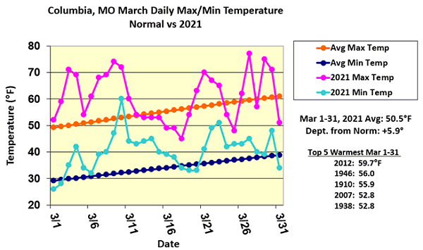
Figure 1.
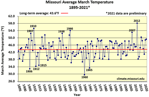
Figure 2.
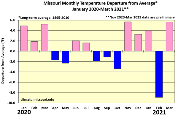
Figure 3.
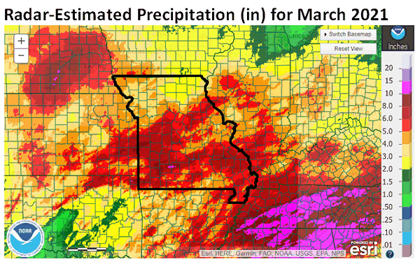
Figure 4.
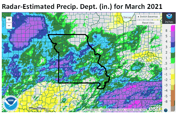
Figure 5.
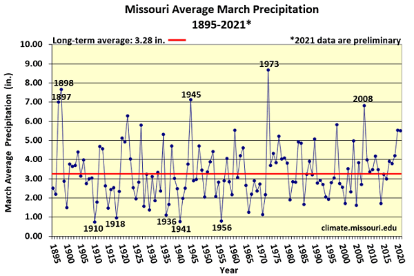
Figure 6.
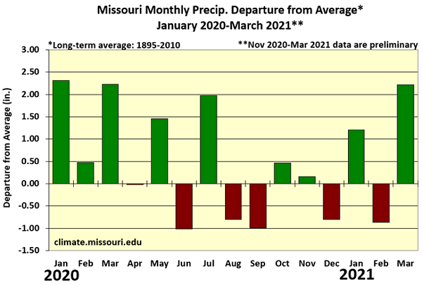
Figure 7.
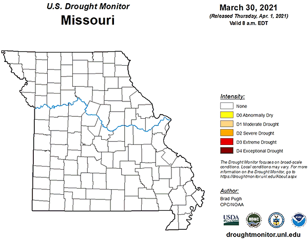
Figure 8.
Source: Pat Guinan, 573-882-5908