
March 2019 Weather and Its Impacts on Missouri
Pat Guinan
State Climatologist
University of Missouri Extension
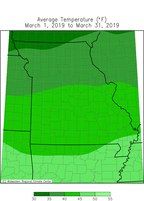
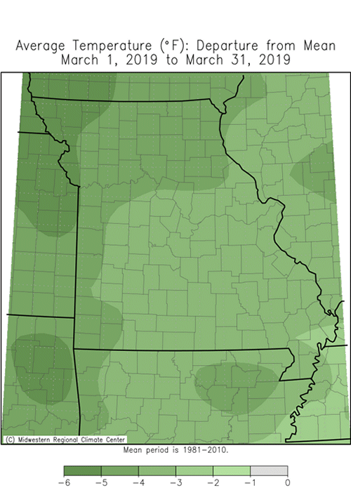
March began on a frigid note in Missouri with the first week being the coldest start to the month in nearly 60 years, Figures 1 and 2. Unusual sub-zero temperatures were reported for a couple days, and penetrated as far south as central Missouri, Table 1. Temperatures moderated and remained seasonable for the rest of the month, Figure 3. Preliminary data indicate the average statewide March temperature was 41.4�, a little more than 2 degrees below the long-term average. It was the second consecutive below normal month, Figure 4, and the coldest March in five years, Figure 5.
| March 2019 Minimum Temperature Extremes* | |||
| Station Name* | County | Min Temp (°F) | Date |
| Corning | Atchison | -6 | 3/4 |
| Grant City 5WSW | Worth | -6 | 3/4 |
| Green Ridge | Pettis | -6 | 3/4 |
| Sedalia Water Plant | Pettis | -6 | 3/5 |
| Bethany | Harrison | -5 | 3/5 |
| Conception | Nodaway | -5 | 3/5 |
| Gallatin 1W | Daviess | -5 | 3/4 |
| Green City 5N | Sullivan | -5 | 3/4 |
| Richmond 3S | Harrison | -5 | 3/4 |
| Unionville | Putnam | -5 | 3/4 |
| *Reports are from the NWS Cooperative Network and Missouri Mesonet | |||
| Table 1. | |||
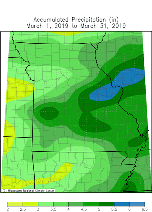
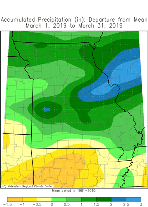
Precipitation was above normal statewide with only a handful of counties in far southern Missouri reporting below normal precipitation for the month, Figure 6. Preliminary data indicate the average statewide March total was 4.24 inches, or nearly 1-inch above the long-term average. It was the wettest March in over a decade, Figure 7. A few light snow events occurred during the first week of March and impacted much of the state, with the exception of southeastern Missouri. Total monthly snowfall accumulations were generally 1-3 inches.
The past four months have been unusually wet in Missouri, Figure 8. It was the wettest Dec-Mar period since 2007-08, and 6th wettest Dec-Mar on record, Figure 9. The wet cold season conditions impacted a large part of the central United States, Figure 10, and contributed toward a historic March flood event over parts of the Missouri River Basin.
The catalyst that led to record flooding along the Missouri River and other tributaries was a widespread extreme precipitation event impacting southeastern South Dakota, southwestern Minnesota, northwestern Iowa and much of Nebraska, Figure 11. On March 13-14 a strong moisture-laden storm system dropped 1-4 inches of precipitation (mostly rainfall) over the 4-state region. The heavy rain fell on a deep snowpack over frozen ground and resulted in significant melting and immediate runoff. Rivers and streams were at capacity prior to the event and the conditions led to rapidly rising rivers and streams with major flooding in the region.
The pulse of high-water flowed downstream with historic flooding occurring along the Missouri River in northwest Missouri. Preliminary river gauge data indicate record crests were established at several locations, Table 2, and Figures 12-13.
| Missouri River record crests in northwest Missouri | ||||
| Location | Record Crest Level* | Date | Prev. Record | Date |
| Brownville, NE | 45.48 ft | 3/16/2019 | 44.79 ft | 6/23/2011 |
| Rulo, NE | 28.14 ft | 3/20/2019 | 27.26 ft | 6/27/2011 |
| St. Joseph, MO | 32.11 ft | 3/23/2019 | 32.07 ft | 7/26/1993 |
| *Preliminary USGS observations | ||||
| Table 2. | ||||
The flooding in northwestern Missouri was devastating, Figures 14-15. Standards of living, agriculture and commerce were adversely impacted and there was a significant hit to the economy. It will be a long recovery process before things return to normal.
According to Extension specialists from the northwest region, the impacts were numerous including:
- 173,000 acres flooded in Atchison, Holt and Buchanan Counties
- Extensive levee damage, all overtopped or breached from Council Bluffs, IA to St. Joseph, MO
- Communities flooded with citizens evacuated
- Numerous roads closed and washed out in places including portions of Interstate 29 which is closed from Council Bluffs, IA to St Joseph, MO
- Livestock producers on river bottoms had to evacuate animals
- There are concerns about water contaminants and how they might affect safety of any forage grazed or harvested that had been flooded, as well as concerns about how long forage can survive under water.
- Local businesses are being impacted because they rely on interstate traffic.
- Ethanol plants closed
- Railroad tracks washed away
- Grain bins, full of grain, destroyed
Extensive flooding also occurred in the Missouri Bootheel during March, due mainly to an extended period of exceptional wetness. Locations in Scott, Mississippi, New Madrid, Dunklin and Pemiscot counties have received more than 20 inches since January 1, Figure 16, and it�s been the wettest first three months of the year in 30 years, or since 1989, Figure 17.
The cool and wet March weather slowed vegetative growth and limited early spring fieldwork activity, especially across southeastern sections. A guide to spring frost/freeze probabilities for Missouri can be accessed at Missouri Frost/Freeze Probabilities Guide.
Jump to:
- Figure 1
- Figure 2
- Figure 3
- Figure 4
- Figure 5
- Figure 6
- Figure 7
- Figure 8
- Figure 9
- Figure 10
- Figure 11
- Figure 12
- Figure 13
- Figure 14
- Figure 15
- Figure 16
- Figure 17
- Figure 18
- Figure 19
- Figure 20
- Figure 21
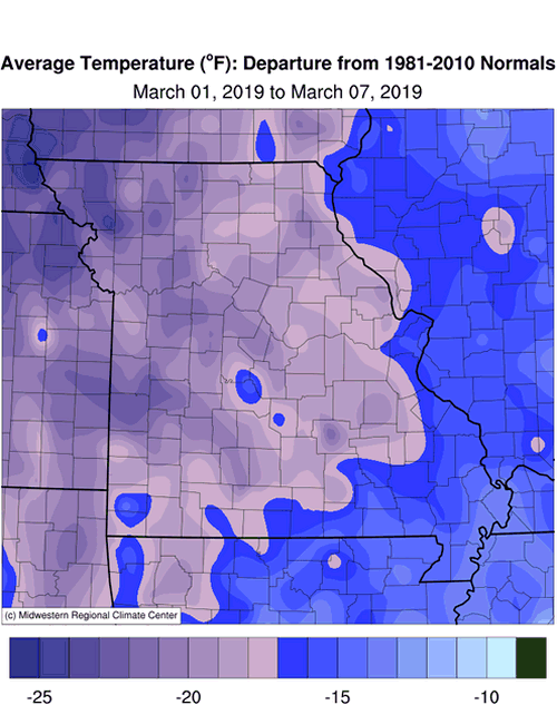
Figure 1.
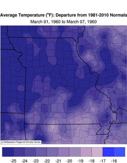
Figure 2.
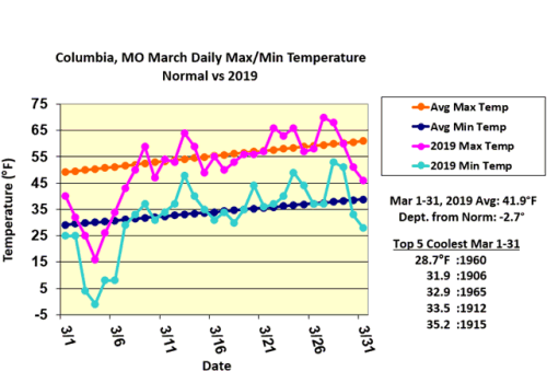
Figure 3.
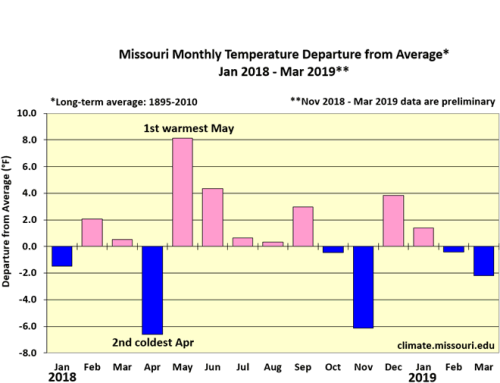
Figure 4.
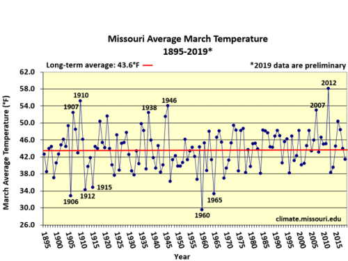
Figure 5.
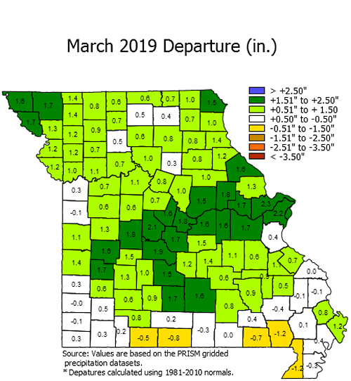
Figure 6.
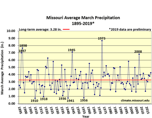
Figure 7.
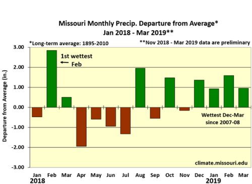
Figure 8.
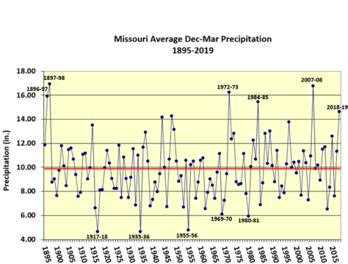
Figure 9.
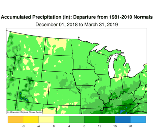
Figure 10.
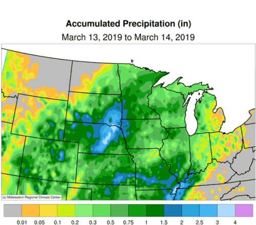
Figure 11.
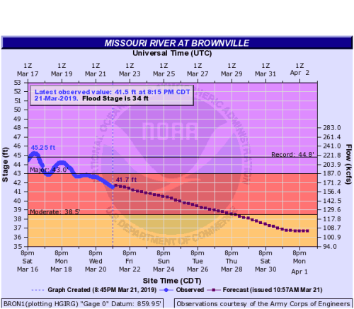
Figure 12.
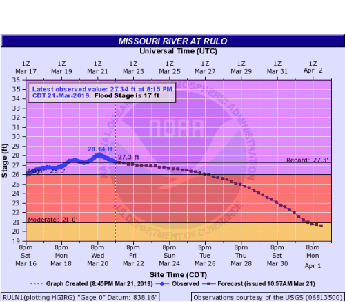
Figure 13.
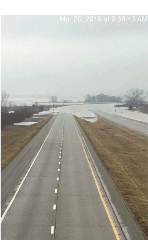
Figure 14. Looking north from the Z overpass on I-29, Atchison County, MO, March 20, 2019. Photo: Jim Crawford
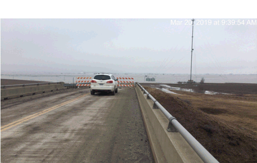
Figure 15. Looking west from the Z overpass, Atchison County, MO March 20, 2019. Photo: Jim Crawford
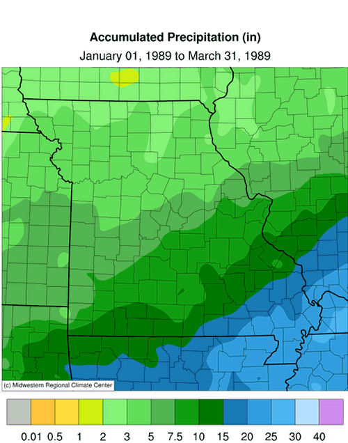
Figure 16.
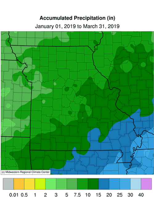
Figure 17.
Source: Pat Guinan, 573-882-5908