
March 2018 Weather and Its Impacts on Missouri
Pat Guinan
State Climatologist
Commercial Agriculture/University of Missouri Extension
March weather was seasonably cool and cloudy across Missouri with occasional showery periods. The damp, dreary conditions were especially notable during the latter half of the month. Solar radiation data from some locations indicate it was the cloudiest March in more than two decades, Figure 1.
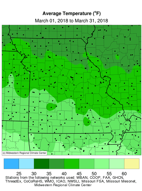
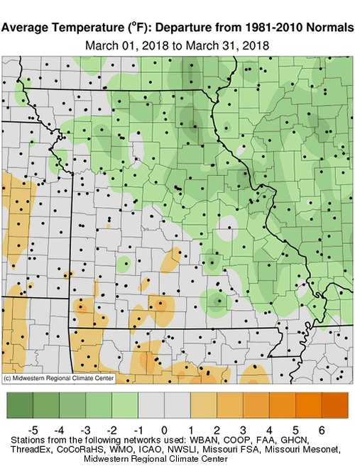
The overcast conditions acted to suppress maximum temperatures, keeping them below normal, whereas minimum temperatures remained elevated, and mostly above normal during the month, Figure 2. Preliminary data indicate the statewide average temperature was 43.0�F, or 0.6� below the long-term average. It was the first below normal March since 2014, Figure 3. The cool monthly weather deviated from the above normal trend that has dominated since early last year, Figure 4.
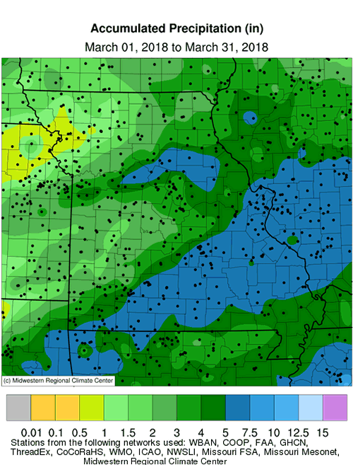
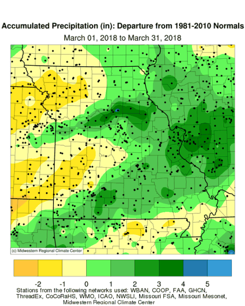
The wet pattern that emerged in February persisted into March. Preliminary data indicate a statewide monthly precipitation average of 3.8 inches, 0.5 inches above the long-term average, Figure 5. Most areas of the state received 3-5 inches during the month with heavier totals, 5-6 inches, reported over east central and south central sections, Figure 6. Lighter amounts, 1-3 inches, were reported over northwestern, north central and much of west central Missouri. Frozen precipitation events were scarce with the most notable event occurring across parts of east central Missouri on March 11, where generally 1-3 inches of snow were reported.
The wet March weather reduced precipitation deficits that had accumulated from last fall into early winter, Figure 7. Biggest improvements occurred across the southern half of Missouri and northeastern sections, where dry conditions were eliminated according to the Drought Monitor map from April 3, Figure 8.
As of early spring, the biggest drought concern for Missouri lies across far north central and northwestern sections, where winter precipitation totals have been notably less, and hydrological drought persists. Surface water recovery has been minimal and sub soil moisture conditions remain dry across the area. Climatology suggests there will be opportunities for moisture improvement across the region as we progress through spring. Average Mar-May precipitation in northwestern Missouri ranges from 10-11 inches, compared to winter (Dec-Feb) totals that range from 3-4 inches.
The cool, cloudy and wet weather pattern minimized evaporative demand, slowed vegetative growth and limited spring fieldwork activity across the state. A guide to spring frost/freeze probabilities for Missouri can be accessed at Missouri Frost/Freeze Probabilities Guide.
Jump to:
- Figure 1
- Figure 2
- Figure 3
- Figure 4
- Figure 5
- Figure 6
- Figure 7
- Figure 8
- Figure 9
- Figure 10
- Figure 11
- Figure 12
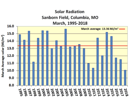
Figure 1.
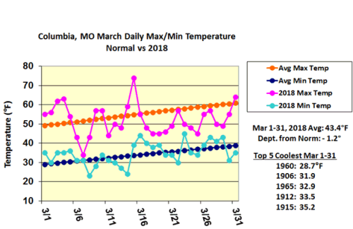
Figure 2.
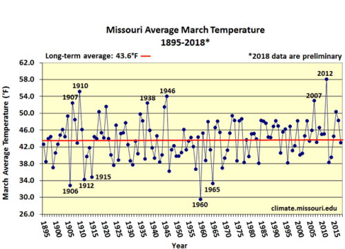
Figure 3.
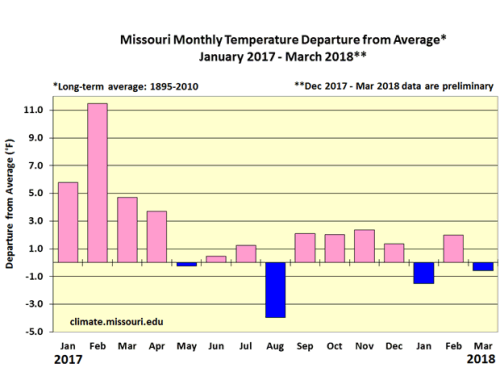
Figure 4.
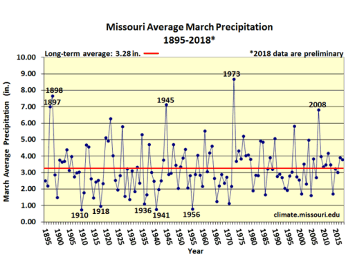
Figure 5.
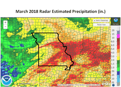
Figure 6.
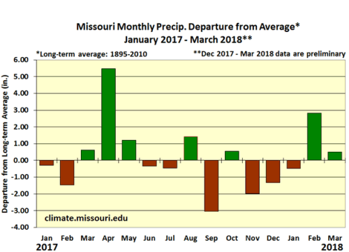
Figure 7.
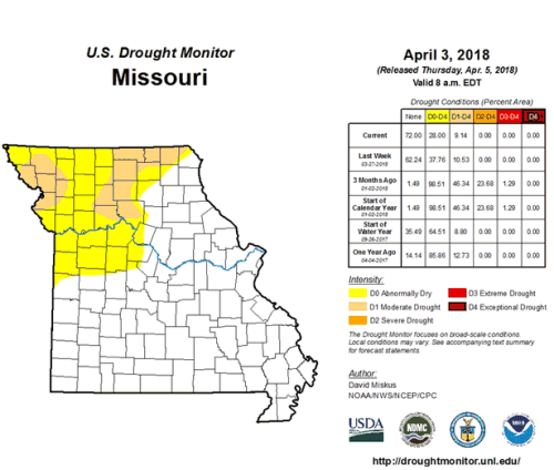
Figure 8.
Source: Pat Guinan, 573-882-5908