
March 2013 Weather and Its Impacts on Missouri
Pat Guinan
State Climatologist
Commercial Agriculture/University of Missouri Extension
The cold and unsettled weather pattern that set up in mid-February persisted for much of March. Preliminary March temperature data for Missouri indicated an average statewide temperature of 38.2°F, or nearly 6 degrees below normal. It was the coldest March in 17 years, when the average statewide temperature in 1996 was 38.0°F, Figure 1. March 2013 was also the largest monthly negative temperature departure since February 2010. With the exception of New England, below normal March temperatures were experienced across the eastern 2/3 of the country, Figure 2.
The major contributor to the cold weather regime was an unusually strong negative phase of the Arctic Oscillation (AO), Figure 3. The AO index is associated with pressure anomalies in the arctic, where negative phases typically translate toward a southern migration of the polar jet into the central and eastern U.S., and a higher likelihood of arctic incursions into the region.
March precipitation was variable across the state, but the overall statewide average was 3.84 inches, or about 0.50 inches above normal. It was the third consecutive month with above normal precipitation for the state, Figure 4. A widespread rain event on March 9-10 brought 1-2 inches to much of the state, and when combined with snowmelt across portions of northern and central Missouri, resulted in notable recovery to surface water supplies. Another significant rain event impacted parts of south central and southeastern Missouri from March 16-18, when 1-3 inches fell over the region. Several locations in Ste. Genevieve County reported more than 4-inches during the event.
Regionally, precipitation was below normal across northwestern and extreme southern sections of the state. The northwest corner of Missouri received less than 1-inch, and severe hydrological drought persisted. Several counties in south central sections reported 5-6 inches for the month.
An early spring snowstorm impacted portions of the Ozarks on March 21st with 4-10 inches of snow falling from Springfield to Lebanon, MO southeastward into north central Arkansas. Thundersnow was reported in some of the heavier convective bands. The 4th major snow event of the season occurred on March 24-25 when 4-12 inches of heavy, wet snow fell across a large part of northern and central Missouri. Heaviest totals of around a foot of snow were reported around the St. Louis metropolitan area. Thundersnow was also reported in several locations, and it was the third thundersnow event of the season for Columbia, MO (Video 1). Much of the state experienced a snowier than normal season, with many locations across northern and central Missouri reporting 25-35 inches of snow, Figure 5. Columbia, MO reported 35 inches, which was the 10th snowiest season on record, or since 1899.
Much below normal March temperatures minimized evaporative rates and slowed vegetative growth. These conditions, in combination with numerous precipitation events since the end of January have provided several opportunities for surface water recovery and soil moisture infiltration across much of the state. Anecdotal soil moisture improvement was noted for mid-Missouri when a hole was dug on March 20, at a research farm just southeast of Columbia, and moisture was found to a depth of 41 inches.
Accordingly, drought conditions have improved across the eastern 2/3 of Missouri. The Drought Monitor map for April 2, 2013 indicates only northwestern and far west central and southwestern sections of the state in moderate to severe drought, Figure 6. The rest of the state is essentially drought-free.
The biggest drought concern for Missouri lies across northwestern sections, where winter precipitation totals have been much lighter, and severe hydrological drought persists. Surface water recovery has been minimal and sub soil moisture conditions remain dry across the region. Climatology suggests there will be opportunities for moisture improvement across northwestern Missouri as we progress into spring. Average Mar-May precipitation ranges from 10-11 inches, compared to winter (Dec-Feb) totals that range from 3-4 inches.
Jump to:
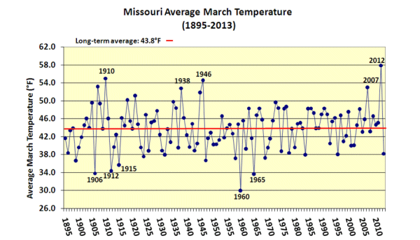
Figure 1 - Missouri Average March Temperature (1895-2013)
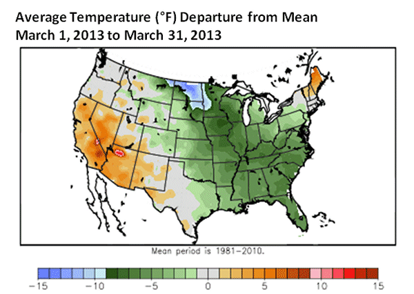
Figure 2 - Avg Temp (°F) Departure from Mean March 1, 2013 to March 31, 2013
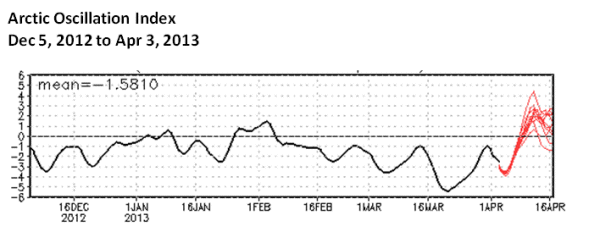
Figure 3 - Arctic Oscillation Index Dec 5, 2012 to Apr 3, 2013
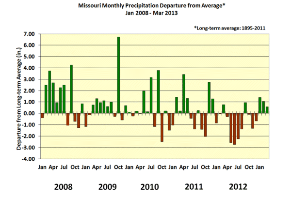
Figure 4 - Missouri Monthly Precip Departure from Average Jan 2008-Mar 2013
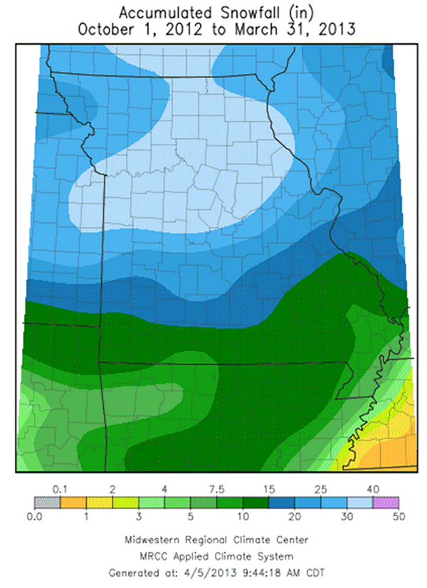
Figure 5 - Accumulated Snowfall (in) October 1, 2012 to March 31, 2013
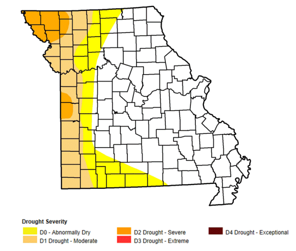
Figure 6 - NOAA/USDA/NDMC Drought Monitor map for April 2, 2013
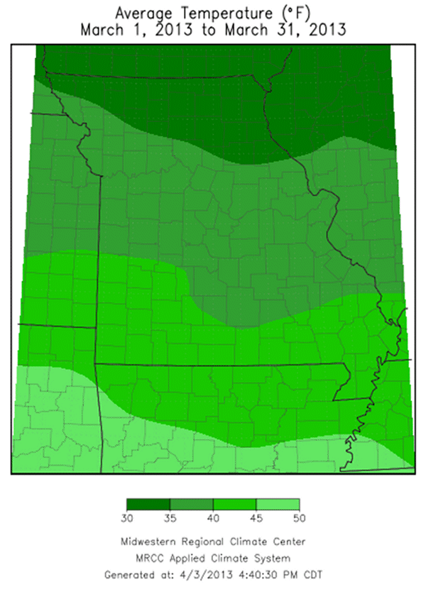
Figure 7 - Average Temperature (°F): March 1, 2013 to March 31, 2013
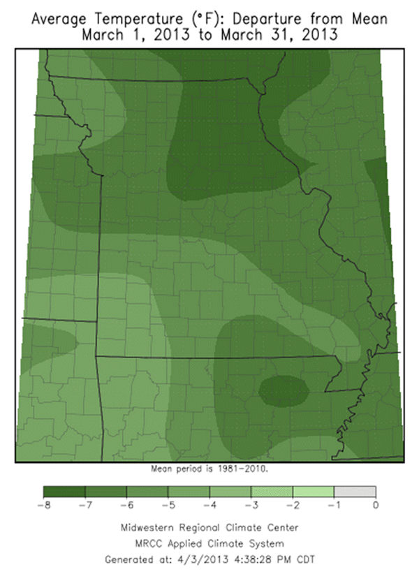
Figure 8 - Avg Temp (°F) Departure from Mean: March 1, 2013 to March 31, 2013
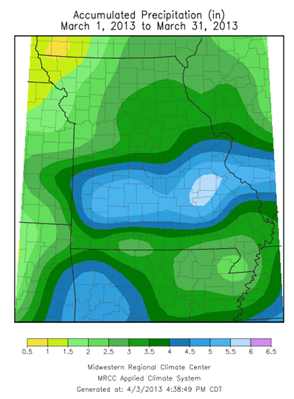
Figure 9 - Accumulated Precipitation (in): March 1, 2013 to March 31, 2013
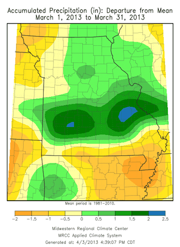
Figure 10 - Accumulated Precip (in): Dept from Mean Mar 1, 2013 to Mar 31, 2013