
| Sanborn Field - Columbia | ||
58°F | ||
| Humidity | 94% | |
| Wind Speed | 2.1 mph | |
| Wind Dir. | SSW | |
| Pressure |  | |
| 61.9°F | ||
| Rainfall | 0.01 in. | |
February 2024 Weather and Its Impacts on Missouri
Dr. Zack Leasor
State Climatologist
Assistant Professor
February 2024 featured record warmth and dryness across the state of Missouri. February's statewide average temperature of 45.9 °F was 12.1 °F above the long-term average and finished as Missouri's warmest February on record back to 1895. February 2024 was 0.8 °F warmer than the previous February record (+ 11.3 °F) set in 2017. February's monthly temperature was even 2.3 °F higher than the March long-term average. Monthly temperature departures of at least 10 degrees Fahrenheit above normal were common, especially in the northern half of Missouri (Figure 1).
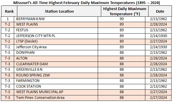
Throughout the month of February, over 250 daily high temperature and 50 daily high minimum temperature records were tied or broken across the state. Several locations recorded their warmest February temperature on record and 7 of the top 15 all-time highest February temperatures recorded in Missouri occurred during February 2024 (Table 1). A high temperature 89 °F was recorded in West Plains (Howell County) and Deslet (Shannon County), falling just one degree short of the 90 °F record set in 1962.
Table 1. Data provided by NOAA's Applied Climate Information System (ACIS)
The record setting warmth during February contributed to Missouri's second warmest winter (DJF) on record, despite below normal temperatures in January. Missouri's statewide average winter temperature was 6.4 °F above average, making it the state's second warmest winter on record, only behind the winter of 1931-32. A strong El Niño pattern during the 2023-24 winter led to well above normal winter temperatures across most of United States, especially the upper Midwest region.
Missouri's statewide average precipitation in February was 0.61" making it the 9th driest February with monthly total precipitation 1.41" below the long-term average. Precipitation totals were lowest in northern and east-central Missouri where many locations recorded precipitation totals less than 0.25" and a National Weather Service rain gauge located in Fredericktown, Madison County recorded no rainfall in February. Saline, Randolph, and Scotland counties all recorded their driest February on record.
Below average precipitation in February reversed the progress of drought recovery that had occurred in late December and through January. Above-average potential evapotranspiration was also notable during February when atmospheric demand is typically negligible. As a result, during the 4-week span from February 6 to March 5, 2024, one-class degradations in US Drought Monitor severity categories were common across the state with even some two-class degradations noted north of Kansas City and in east-central Missouri (Figure 3). By March 5, greater than 99% of Missouri was classified as at least abnormally dry with 46% of the state classified in drought. This stalled winter soil moisture recharge and resulted in streams and rivers running well below their seasonal average.
Missouri's February wildfire risk was elevated due to many warm, dry, and windy days. According to the Missouri Department of Conservation, there were over 500 wildfire and wildfire ignition reports during February including a 1200-acre fire in Camden County on February 23 and a 1700-acre fire in Ozark County on February 27. Other impacts from the anomalous warmth and dryness in February 2024 included advanced spring phenology, opportunities for early agricultural fieldwork, reduced springtime river flooding risk, and a lack of snowfall. February snow totals in Missouri were generally less than 2 inches, with slightly higher monthly totals up to 4" south of Springfield and in the St. Louis area (Figure 4). Through the end of February, nearly all of Missouri is below average for 2023-2024 seasonal snowfall (Figure 5).
Jump to:
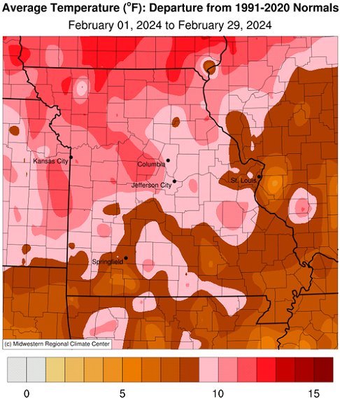
Figure 1.
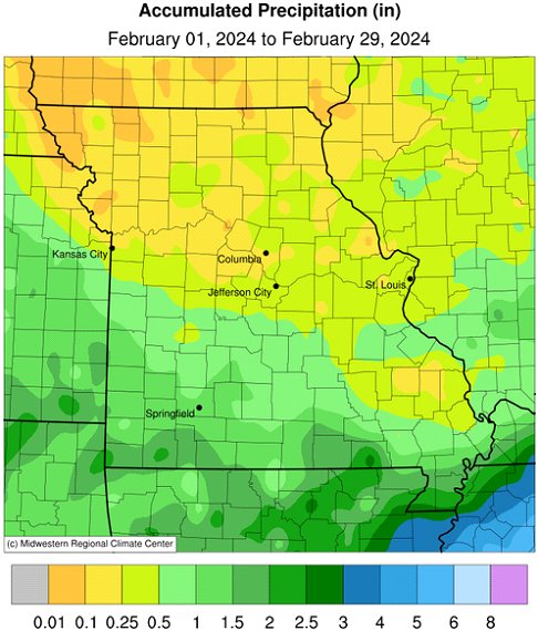
Figure 2.
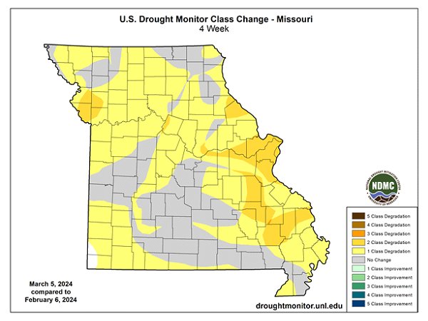
Figure 3.
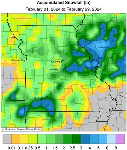
Figure 4.
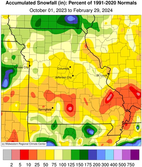
Figure 5.
Source: Dr. Zack Leasor | 573-882-5908